Tropical Storm Debby Impacts Update for August 6th
Debby's major impacts on Florida have ended; extreme flash flooding risks will continue through the week in the coastal Southeast.
Sign up for WeatherTiger’s hurricane forecast newsletter by clicking here:
Florida and continental U.S. tropical threat synopsis: Tropical Storm Debby is near the GA/SC coastline. No further destructive impacts are expected in Florida; coastal Georgia into eastern North Carolina are at high risk of flash flooding over the next 3 days as Debby crawls along the coast.
Almanac: It’s Thursday, August 6th… day 67 of the 2024 hurricane season, 116 days to go. By total storm energy, the season is 8.4%, 19.9%, and 13.2% complete for the Atlantic, continental U.S., and Florida, respectively.
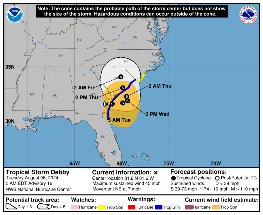
Active storms: Tropical Storm Debby is located close to Savannah, GA this morning, moving northeast at 7 mph. Debby’s sustained winds are down to 45 mph as of the NHC’s 8 a.m. intermediate advisory, and are almost all east of the center. Tropical Storm Warnings continue from Jacksonville to the SC/NC border, with Storm Surge Warnings also in effect for coastal Georgia to north of Charleston, SC.
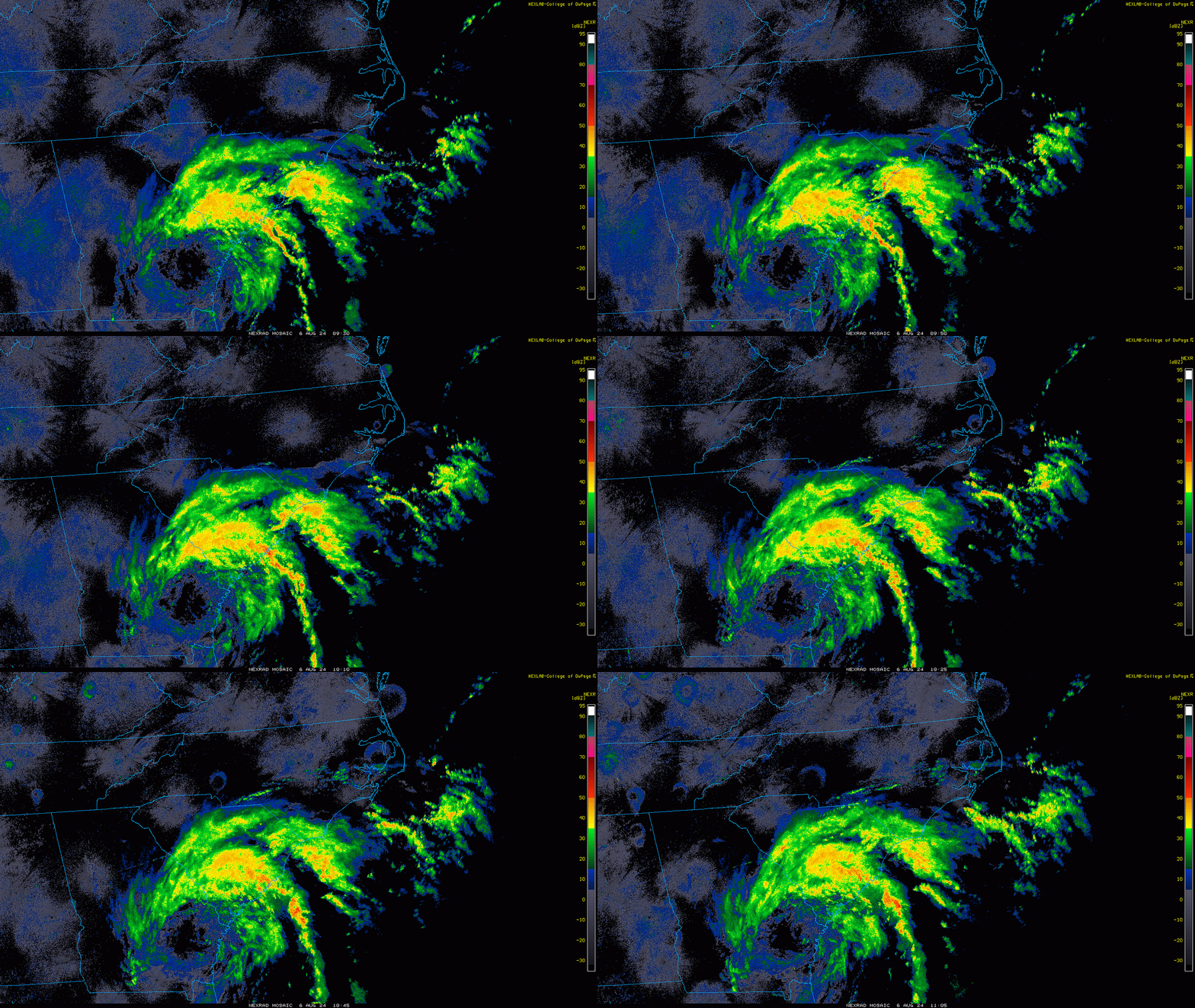
Debby has spent the last 24 hours over land since making landfall as a Category 1 hurricane, and is worse for wear after its journey. The circulation is now broad, with deep convection displaced well northeast of the center. The NHC forecast track eases Debby back out over water by this afternoon and doesn’t bring it back ashore in south Carolina until Thursday, a scenario in which models are finally in better agreement. However, Debby’s structural changes will make it difficult for much re-intensification to occur. The NHC is calling for Debby to be a tropical storm with winds of around 60 mph at second landfall, which squares with how the system is looking today.
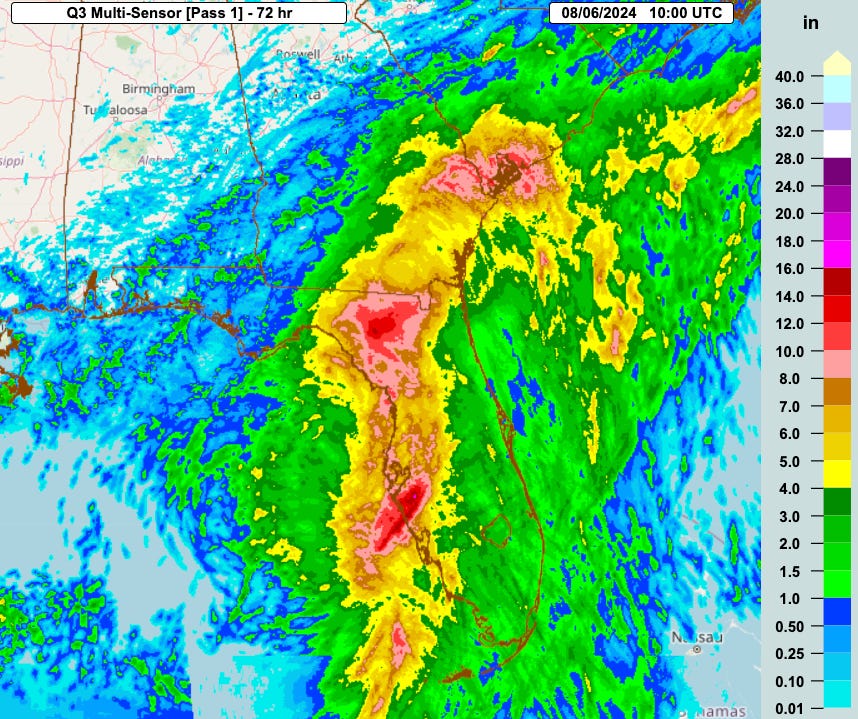
As expected, going forward rain impacts are by far its greatest threat to life and property. Over the past 3 days, Debby has blazed a broad swath of 5-10”+ rain accumulations from west-central Florida, through the Suwannee Valley, and now north into southern South Carolina. (These totals were more like 4-8” in eastern Georgia, where drier air working into Debby’s core late yesterday kept accumulations in check.) Currently, Florida has dried out and no further significant impacts from Debby are likely, and light to moderate intermittent showers continue across eastern Georgia. Heavy rainfall extends over central and eastern South Carolina in association with Debby’s remaining deeper convection, displaced northeast of its surface center.
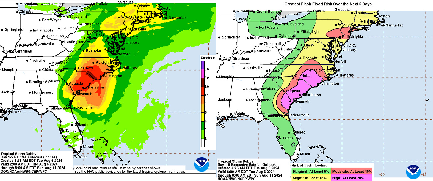
Flash Flood Warnings are currently in effect from Savannah to Charleston. As Debby moves slowly east and then north over the next two days, the area between Savannah and Wilmington, plus about 100 miles inland, is the region most likely to see heavy rain bands “train” overhead and produce another 8-15” of rainfall, potentially even more locally. These excessive rainfall totals, falling on already saturated ground, mean a very high risk of flash flooding in the eastern Carolinas through Friday. (The flood prognosis has improved somewhat in eastern Georgia, although that area is at an elevated risk of flooding if heavier banding returns to the region tomorrow.) As Debby finally accelerates north and northeast inland between Thursday and Saturday, there is also a high likelihood of widespread 3-6”+ totals from Virginia north into southern New England, which could produce flash flooding there as well.
Finally, while peak Debby’s winds have slackened, it still is producing a broad region of low-end tropical-storm-force winds offshore. These winds are now causing and will continue to create 2-4’ of storm surge focused on coastal South Carolina through Thursday. While surge is no longer the primary hazard from Debby, coastal flooding due to strong onshore winds will exacerbate the other water impacts. This is especially true as the region of the greatest surge in South Carolina coincides with the area with the best chance of seeing another 10-12”+ of rainfall from Debby.
Bottom line is that Debby is entering its grinding second phase, and those long-predicted risks of flooding rainfall are already starting to come to fruition in the coastal Southeast. Look for another two to three days of heavy rain in the Carolinas before the rain shifts farther north up the East Coast.
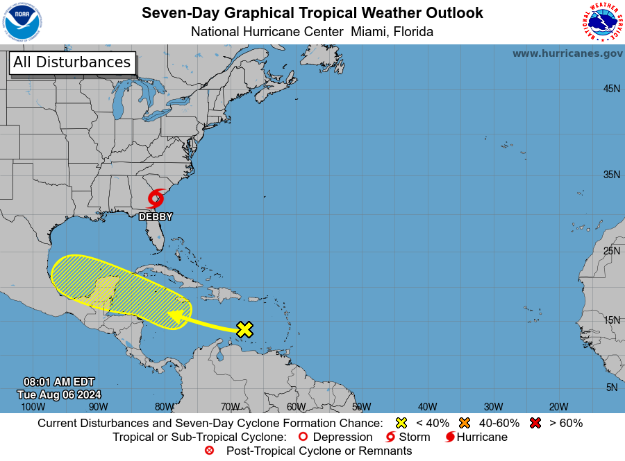
Disturbances in the NHC tropical weather outlook: I’ve been ignoring this one for a few days, but there is a tropical wave in the eastern Caribbean currently with a 10% chance of developing in the next two days and a 30% chance in the next 7 days. This wave will probably wind up in the southern Gulf this weekend, though U.S. southern tier ridging should keep it from turning north. Might be something to monitor in south Texas, but not really a concern for the rest of the U.S. Gulf Coast.
Elsewhere: Models show the eastern Atlantic wave train potentially perking up next week as conditions become more favorable for development. Nothing specific to watch yet as we approach a likely ramp up in tropical activity mid-month.
Next update: Tomorrow morning.


![[Image of cumulative wind history] [Image of cumulative wind history]](https://substackcdn.com/image/fetch/w_1456,c_limit,f_auto,q_auto:good,fl_progressive:steep/https%3A%2F%2Fsubstack-post-media.s3.amazonaws.com%2Fpublic%2Fimages%2F56155350-1a99-4468-81fc-f10061456f34_897x736.png)
I had thought of some trivia type questions while I was laying around yday in Tallahassee watching this one inch across. Has there been a year on record without any hurricanes, or at least only fish storms? How common is it for storms to make landfall in almost exactly the same spot like Idalia and Debby? Has that ever happened in the same year? Hope you get a chance to answer these!