


Time Keeps on Slipping: WeatherTiger's Hurricane Watch for June 9th
Any potential Gulf tropical system continues to remain a week or more away.

Welcome to WeatherTiger’s Hurricane Watch! Each weekday we’ll have a tropical briefing bringing you that day’s hurricane history, a run-down of active storms, and a look at current development threats. Paid subscribers will receive these daily briefings and be able to comment and ask questions, as well as get our Thursday long-form analysis columns, daily forecasts and video discussions during hurricane threats, live landfall coverage, and expanded seasonal outlooks. Free subscribers will receive our weekly forecast column.
A free preview of our daily briefing will continue into June as we settle into our new Substack digs. Enjoy, and feel free to drop a line to ryan@weathertiger.com with any questions.
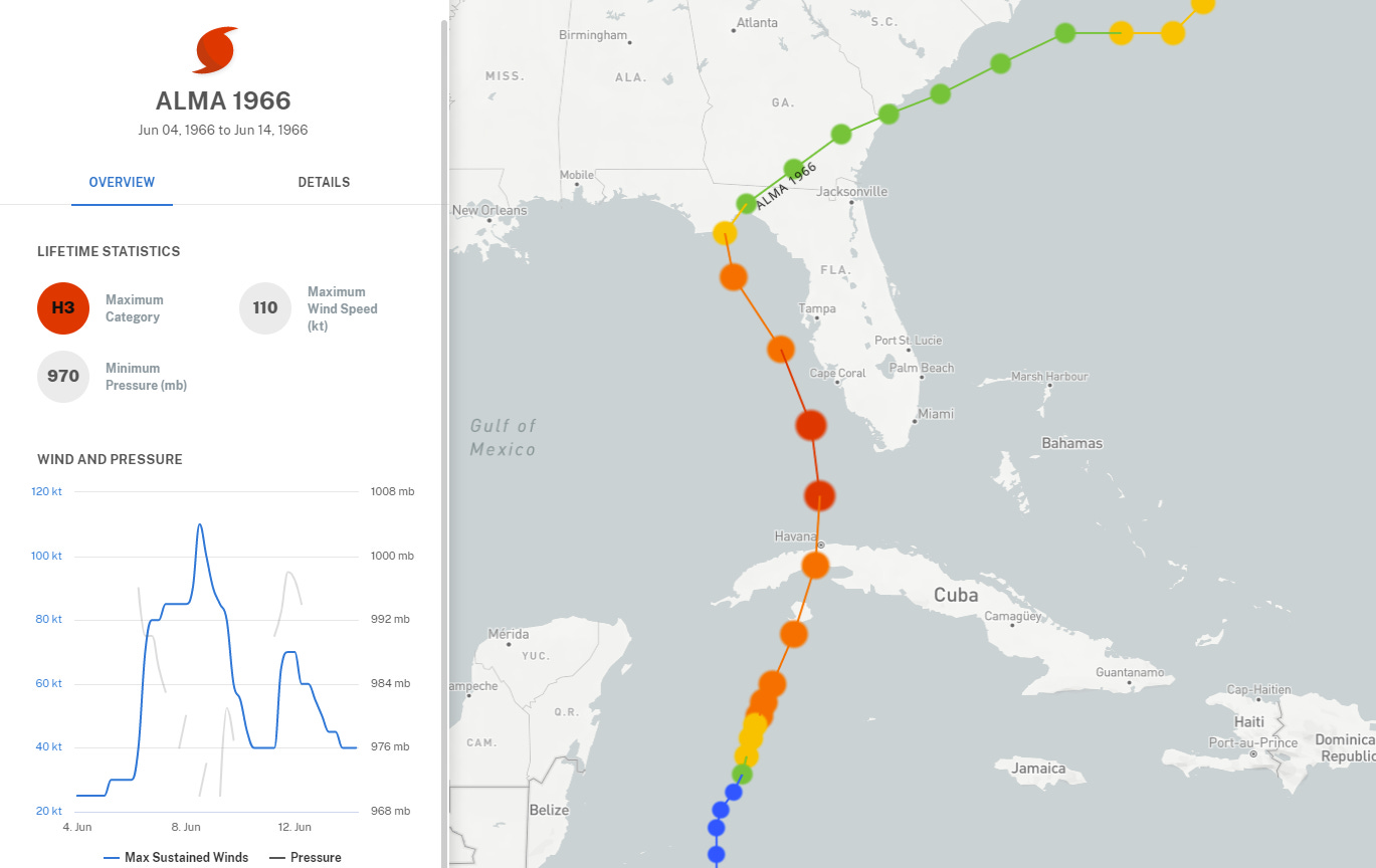
Alma-nac: Today is Wednesday, June 9th… day 9 of the 2021 hurricane season, 175 days to go. By total storm energy, the season is 1.2% complete as a whole, 2.1% complete for the continental U.S., and 2.8% complete for Florida. A notable landfallversary today is Hurricane Alma, the only hurricane to make U.S. landfall in the first half of June since 1900. Alma struck Florida’s Big Bend on this date in 1966 as a high-end category 1 hurricane, causing significant flooding along the Gulf Coast and wind gusts to 100 mph in Crawfordville, FL.
Alma developed in the northwestern Caribbean, which is a typical genesis point for early June. Alma’s peak intensity (125 mph-packing Cat 3) and landfall strength, however, are highly atypical for June.
Active Storms: None.
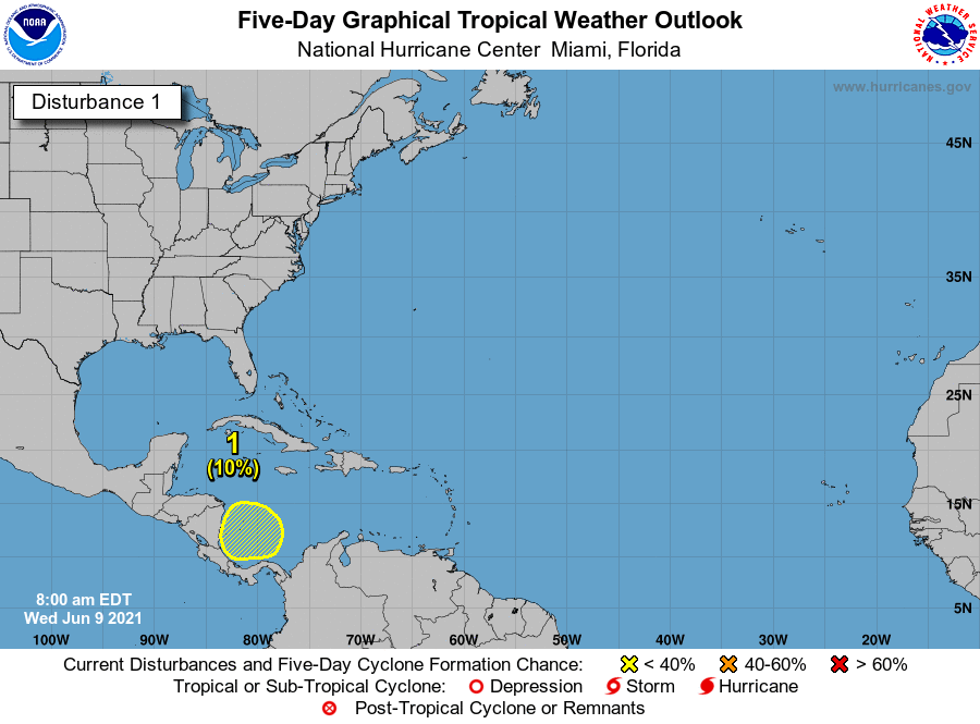
Current disturbances in NHC outlook:
Southwestern Caribbean (2-/5-day odds: 0/10%). Disorganized storminess continues this afternoon over the southern Caribbean, which will linger into the weekend as a broad Central American gyre of turning in low-level winds spins up. Atlantic tropical development remains unlikely in the next 5 days, with upper-level winds favoring development on the Pacific side of Central America early next week. NHC odds for Caribbean development have ticked downward from 20% yesterday to 10% today through day 5.
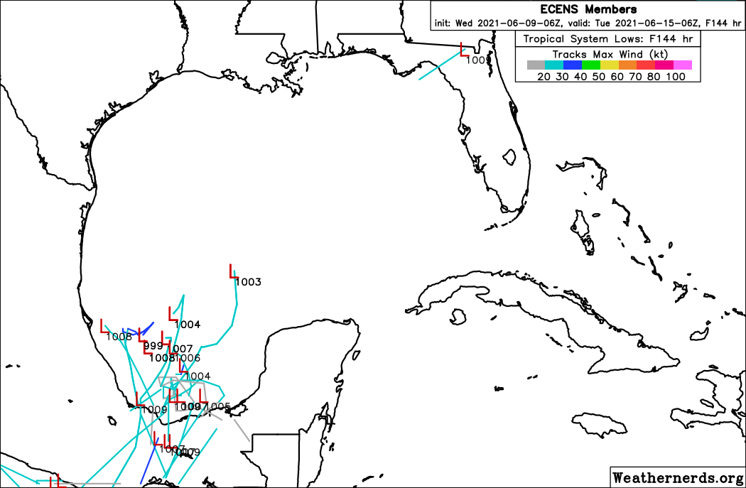
Upper-level winds may become more conducive in the southern Gulf for a lobe of the gyre to split off into a tropical cyclone in 6-10 days, as shown above on a handful of 06z Euro Ensemble members for next Tuesday morning. Model support remains inconsistent, and development has been hanging out in the day 7 to 9 range on the operational GFS and Euro for about the past week. Overall, while the southern Gulf is worth watching around the middle of next week, I would continue to characterize overall risks to the U.S. Gulf Coast as low until a more consistent signal for development inside of the five day range on guidance appears. Nothing to do but keep watching until then.

Elsewhere: Quiet. Low pressure developing off the Southeast Coast early next week along an old front is likely to be swept east quickly before tropical transition can occur.
Next report: Our weekly long-form analysis column discussing the extraordinarily busy June and July of the 1886 hurricane season will be out tomorrow by 3 p.m.