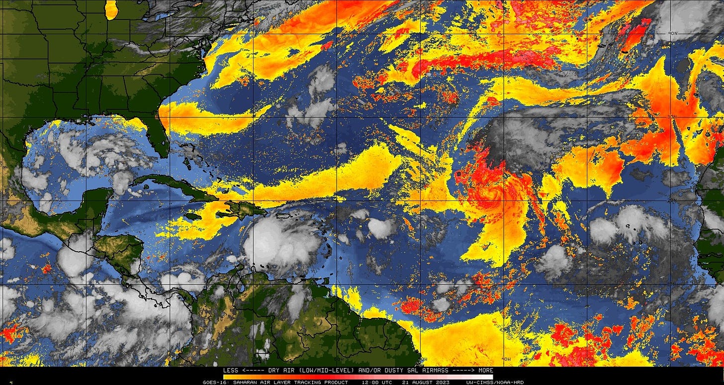
The Threatdown: The Hurricane Watch for August 21st
A complete ranking of the many, many active storms and tropical disturbances to kick off your week.
Enjoy this sample of WeatherTiger’s daily tropical bulletins, just one of the many benefits of being a paid supporter of the Hurricane Watch. Sign up here to receive these forecasts all year.
Florida tropical threat synopsis: No tropical threats to Florida in the upcoming week. Given the pattern, Florida and the Gulf Coast will need to keep an eye on the northwestern Caribbean and eastern Gulf of Mexico in 8-12 days.
Almanac: It’s Monday, August 21st… day 82 of the 2023 hurricane season, 101 days to go. By total storm energy, the season is 16.3%, 29.9%, and 20.5% complete for the Atlantic, continental U.S., and Florida, respectively.
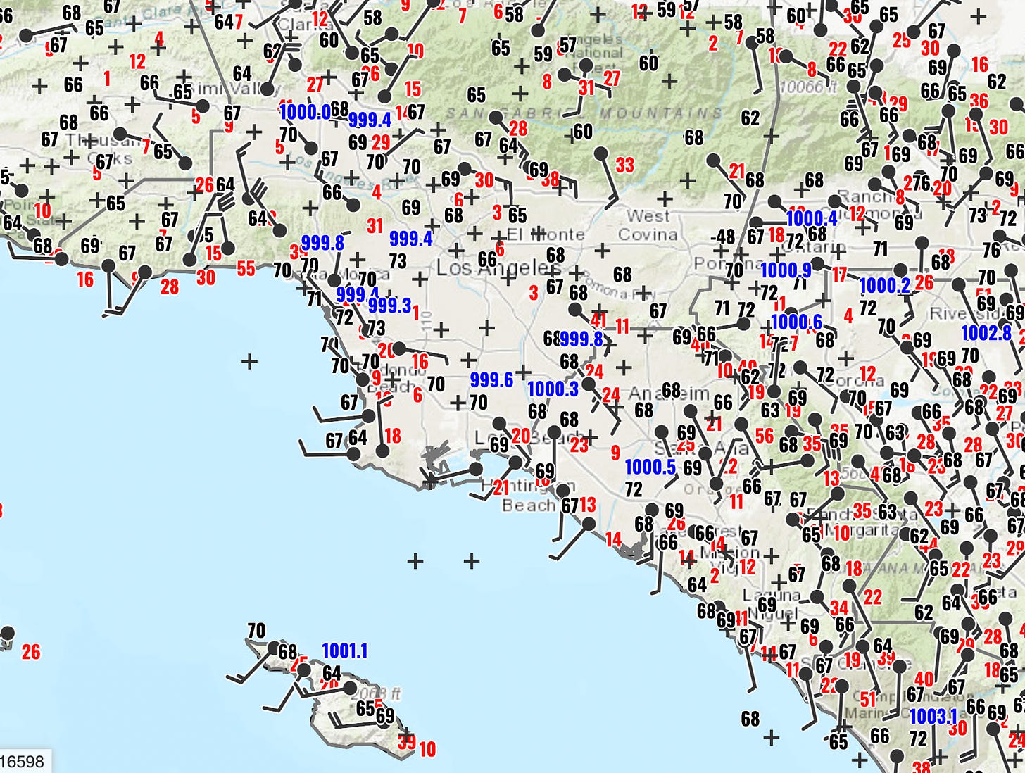
Well, it happened. Last night, Hilary crossed over Southern California as a tropical storm (in fact, the circulation center went directly over downtown L.A., as seen above), the first system to pass over the Southwestern U.S. at that strength since Nora in 1997. Hilary’s primary impacts, as expected, were extreme precipitation, particularly at higher altitudes. The flooding threat continues today further inland across the western U.S.
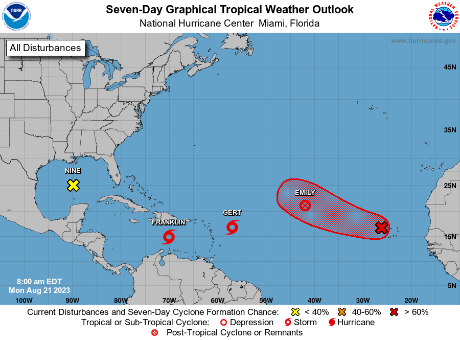
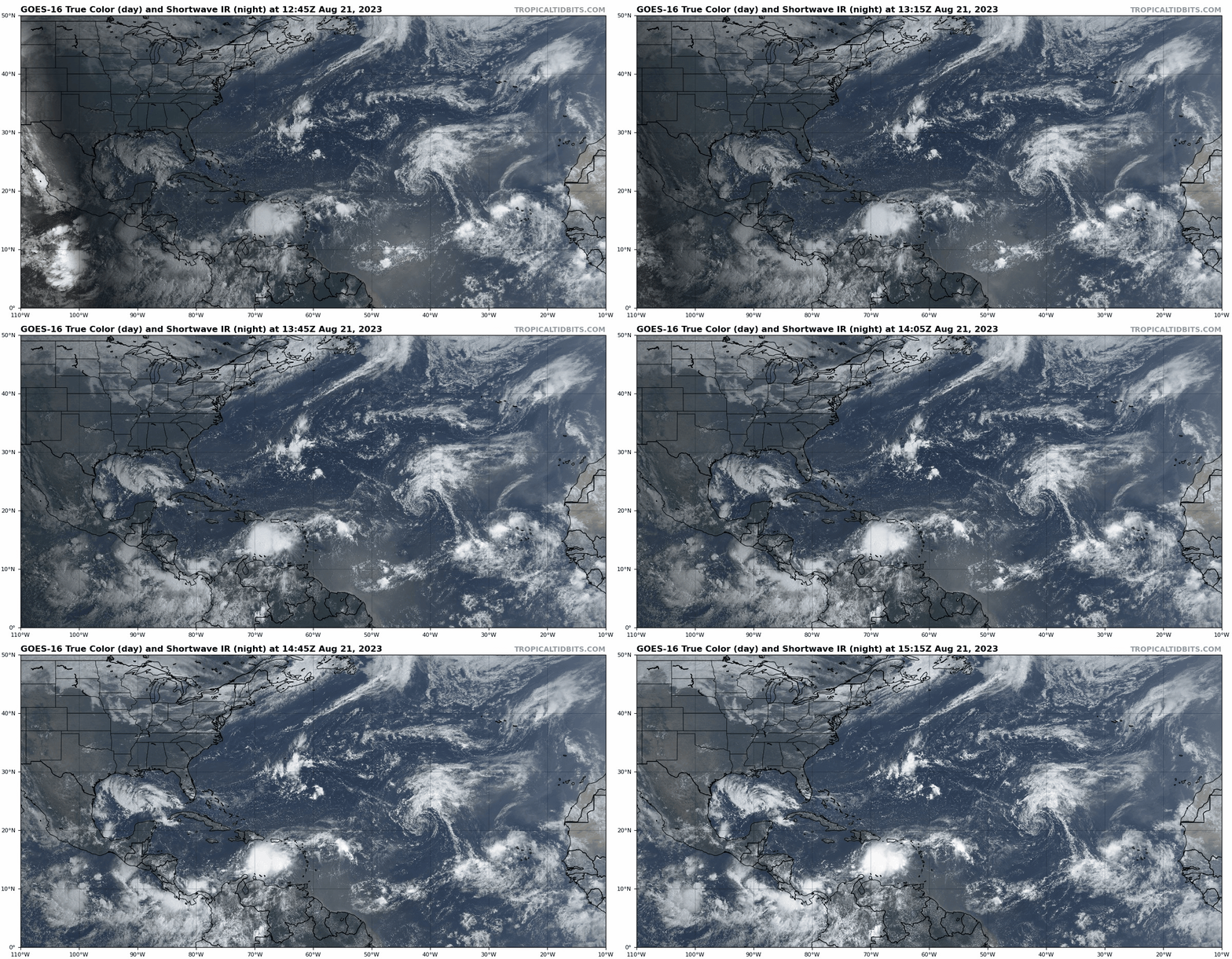
Active Storms: So many. And more to come. Let’s do this from most to least impactful.
Potential Tropical Cyclone Nine: The newest entry on this list and the only one that will have significant impacts on the continental U.S., the NHC has initiated advisories on PTC9 at 11 a.m. Nine is rapidly coming together in the central Gulf of Mexico this morning, and should become Tropical Storm Harold overnight as it races west towards landfall in southern Texas.
PTC9 is in a favorable environment for strengthening, but time is the limiting factor here with landfall tomorrow morning north of Brownsville. Tropical Storm Warnings have been issued for the southern Texas Coast, and landfall intensity of 45-60 mph is probable. The key impact will be 2-5” of rainfall in a portion of drought-added Texas roughly bounded by Brownsville, Corpus Christi, and Laredo. Overall, impacts will be minor or even beneficial. Just be glad this one doesn’t have a second day over water temps in the upper 80s to work with.
Tropical Storm Franklin: The other active storm that will impact land is Tropical Storm Franklin, which developed yesterday about 350 miles south of San Juan and is located in the east-central Caribbean this morning with maximum winds of around 50 mph. Franklin mostly consists of one massive convective burst, and is slowing down in preparation for an imminent turn north towards Hispaniola. Franklin will cross the Dominican Republic on Wednesday with heavy rainfall in tow, and then turn northeast due to troughing over the western Atlantic.
This troughing means Franklin is no threat to Florida or the continental U.S., but several days of slow, east or northeast motion north of Puerto Rico may bring an extended period of heavy rainfall chances to Puerto Rico this week. Franklin may also may well become the season’s second hurricane on a path north towards Bermuda and eventually Maritime Canada this weekend and early next week.
Tropical Storm Gert: Tiny Gert, formerly TD6/Invest 99L, is barely hanging about 500 miles east of Puerto Rico. Gert’s minimal amount of convection is getting stripped away from its small circulation by shear driven by Franklin’s outflow, and it is likely dissipate in the next day with little chance of regenerating.
Post-tropical Cyclone Emily: Emily, which developed Sunday morning from Invest 98L, was an open-ocean storm with vibes so chill that it barely existed. Following a convective burst over the weekend, dry air has fully enveloped the circulation, and as of 11 a.m. the lack of significant storms means Emily no longer meets the definition of a tropical cyclone. It might reform in 2-4 days as it races north in the open Atlantic, but will not impact any land even if so.
Other Disturbances in NHC outlook, with 2-/7-day NHC development odds: The only feature currently on the map that hasn’t developed is Invest 92L, a tropical wave in the far eastern Atlantic. NHC is giving this a 40% chance of development over the next 2 days and a 70% chance over the next seven days. With low shear and much better moisture availability in the eastern Atlantic for this wave, eventual development is likely. However, given how much latitude it will gain this week, 92L is extremely unlikely to be a U.S. threat down the road.
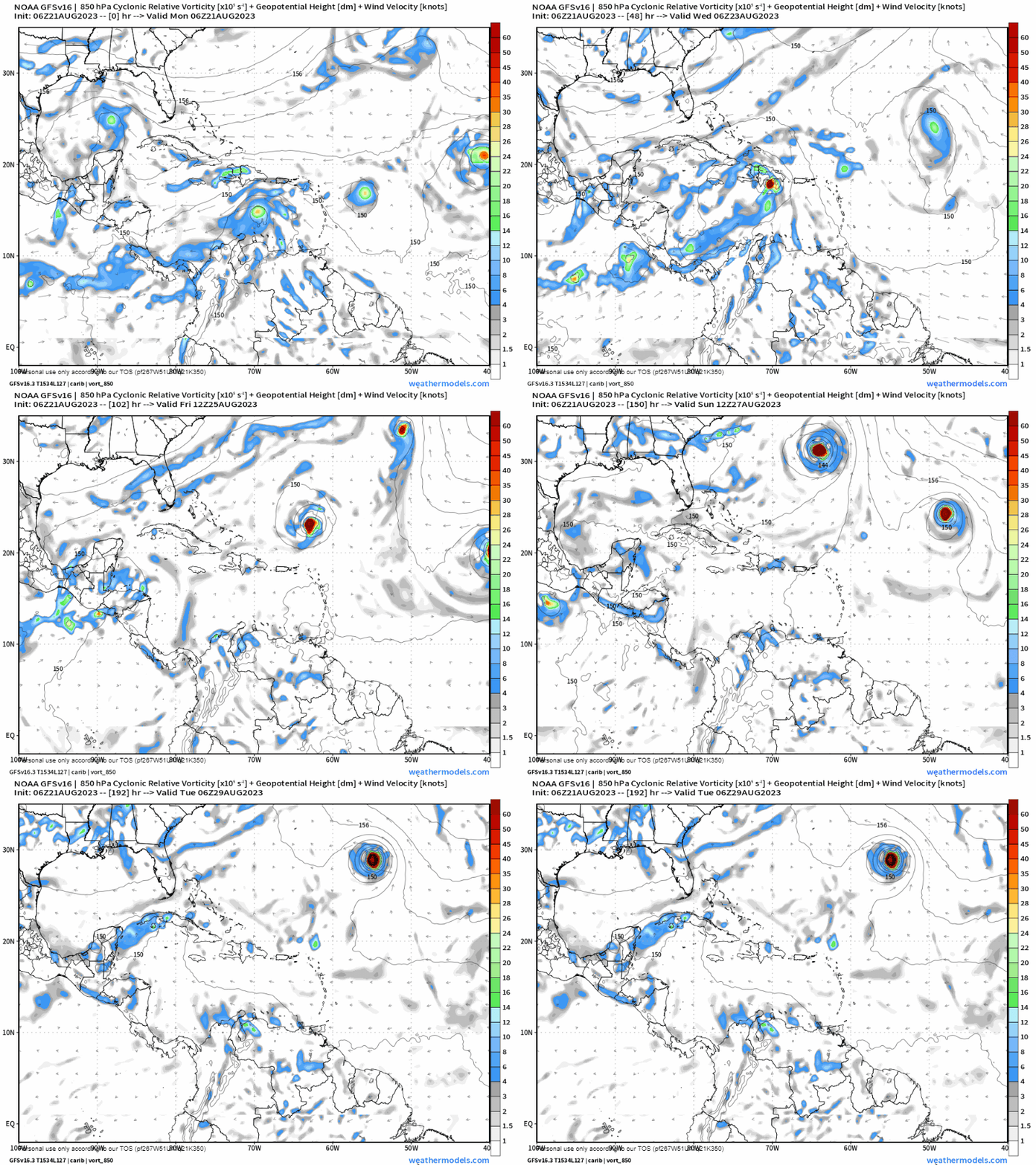
Elsewhere: And finally, there are still some indications of a Central American gyre firing up later this week, which may spit some low-level rotation into fairly favorable conditions for storm development in the southern Gulf or northwestern Caribbean in 6-8 days. With south-to-north steering currents, anything forming from this would be a concern for the U.S. Gulf Coast, but there is nothing to see as of yet. Watch and wait. Otherwise, there is always a chance of additional development of eastern or central Atlantic tropical waves in 6-10 days, but we’ll take those as they come.
Next report: Weekly column out tomorrow afternoon.


![[Image of WPC QPF U.S. rainfall potential] [Image of WPC QPF U.S. rainfall potential]](https://substackcdn.com/image/fetch/w_1456,c_limit,f_auto,q_auto:good,fl_lossy/https%3A%2F%2Fsubstack-post-media.s3.amazonaws.com%2Fpublic%2Fimages%2Fa40e085f-a6f9-4814-a049-7e9704bd095f_892x716.gif)

