


Subtropical Storm Nicole Forecast Analysis for November 7th
Nicole's coastal flooding, gusty winds, and intermittent heavy rain will begin along the Florida East Coast Tuesday and expand northwest through week's end.

This post may be shared freely. If you are a free subscriber, please consider a paid subscription to support the Hurricane Watch. You’ll get supporter-exclusive, Florida-focused tropical briefings, plus full coverage of every U.S. hurricane threat, and the ability to comment on posts, ask questions, and get answers from a tropical meteorologist.
THIS POST IS NOW OUTDATED. PLEASE READ WEATHERTIGER’S NEWEST FORECAST FOR NICOLE AT THE LINK BELOW:

Original forecast continues here.
I don’t want to write this, and you don’t want to read this.
And yet, here we are. Subtropical Storm Nicole is wending towards Florida, and widespread coastal flooding, gusty winds, and intermittent heavy rain will begin along the Florida East Coast on Tuesday. There is more uncertainty in potential impacts for North Florida, which are a possibility later this week.

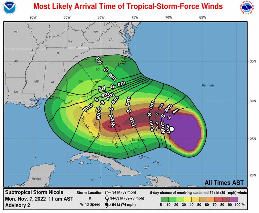
As of early Monday afternoon, the broad center of Nicole is located halfway between Bermuda and the southwestern Bahamas, rolling northwest at about 10 mph. A pivot to the west and west-southwest will occur on Tuesday, as a September-like ridge of high pressure over the mid-Atlantic blocks Nicole from turning out to sea. Nicole will near the southeast Florida coastline late Wednesday, and Hurricane Watches are now in effect from Cape Canaveral south to Broward County. Storm Surge Watches are also up for much of Florida’s East Coast.
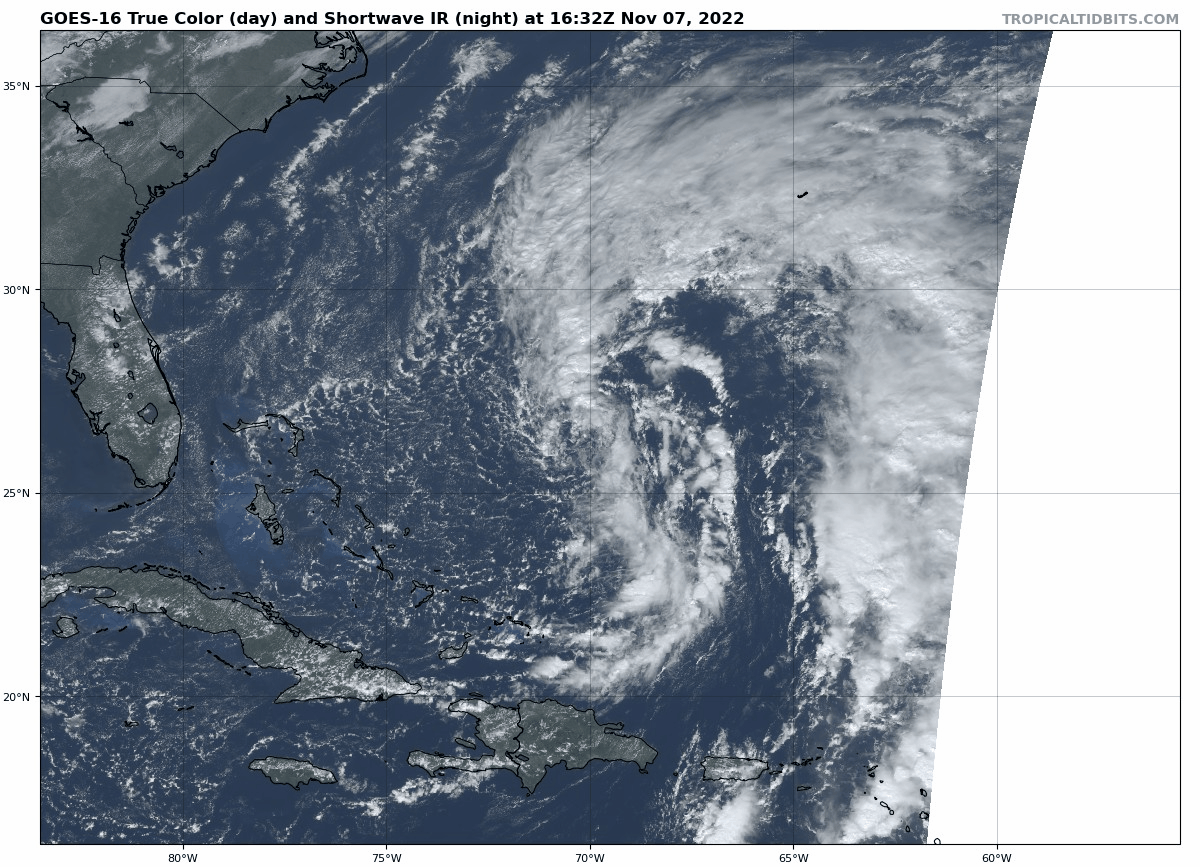
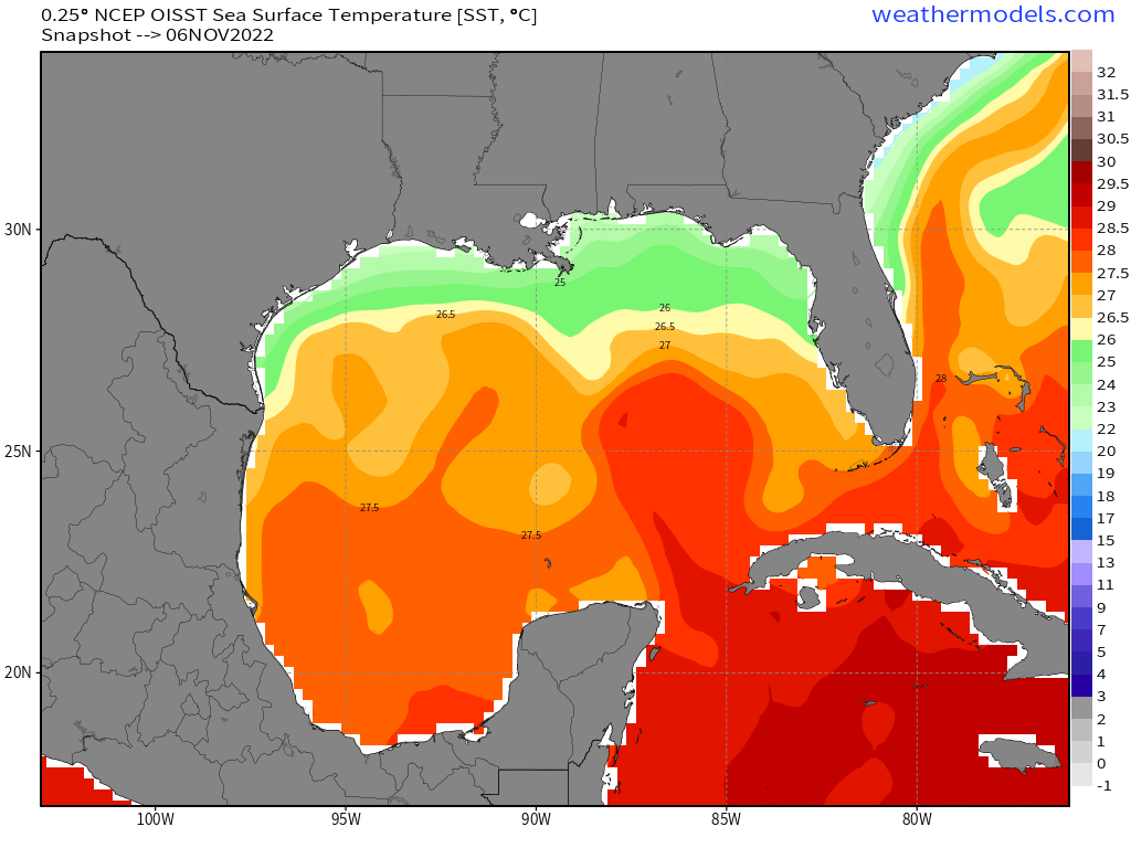
Nicole is a strange, noisome beast all around. The storm is tangled up with an upper-level low, resulting in a broad subtropical structure in which tropical-storm-force winds and heavy rainbands extend hundreds of miles north and northwest of the center of circulation. While Nicole lacks an intense, well-organized convective core today, one may try to gradually develop late Tuesday and Wednesday as the storm traverses Gulf Stream, where sea surface temperatures are still in the lower to mid-80s.
As such, the NHC intensity forecast calls for Category 1 strength at first landfall as a smaller, tropical core may develop within Nicole’s very broad larger circulation. Landfall as a strong tropical storm is also possible, and would little diminish Nicole’s wider impacts. Rapid intensification to a Category 2 or beyond is highly unlikely due to Nicole’s initial hybrid structure.
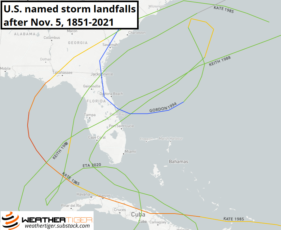
If you have a strong sense that you shouldn’t have to deal with this, I can’t disagree with you: there is scant climatological precedent for Nicole's late-season threat to Florida. Only five named storms since 1851 have ever made a continental U.S. landfall after November 5th, all on the Florida Gulf Coast. Just one, Kate in 1985, was a hurricane.
Still, deal we must. By virtue of Nicole’s size and a tight pressure gradient with strong high to the north, coastal flooding and storm surge will begin Tuesday over much of Florida’s East Coast, worsening through the day Wednesday north of where Nicole makes landfall, and easing on Thursday as winds turn more parallel to shore. Surge will be further exacerbated by the outsized “king tides” caused by Tuesday’s full moon. (As further proof of maximum celestial alignment, Tuesday morning is a full lunar eclipse; while maritime lore is silent regarding the meteorological implications of a red moon at morning, I’m going to say that it’s an ill portent.)
![[Image of cumulative wind history]](https://substackcdn.com/image/fetch/f_auto,q_auto:good,fl_progressive:steep/https%3A%2F%2Fbucketeer-e05bbc84-baa3-437e-9518-adb32be77984.s3.amazonaws.com%2Fpublic%2Fimages%2F22c6e716-98df-4b35-94fd-8ac74b67d0ff_897x736.png "[Image of cumulative wind history]")
With several days of a long onshore fetch plus lunacy to boot, coastal Broward County to as far north as South Carolina are likely to see peak inundations of three to five feet above mean high tide through Thursday. If you are anywhere in this area, refer to your local emergency management authority for any actions needed to preserve life and property.
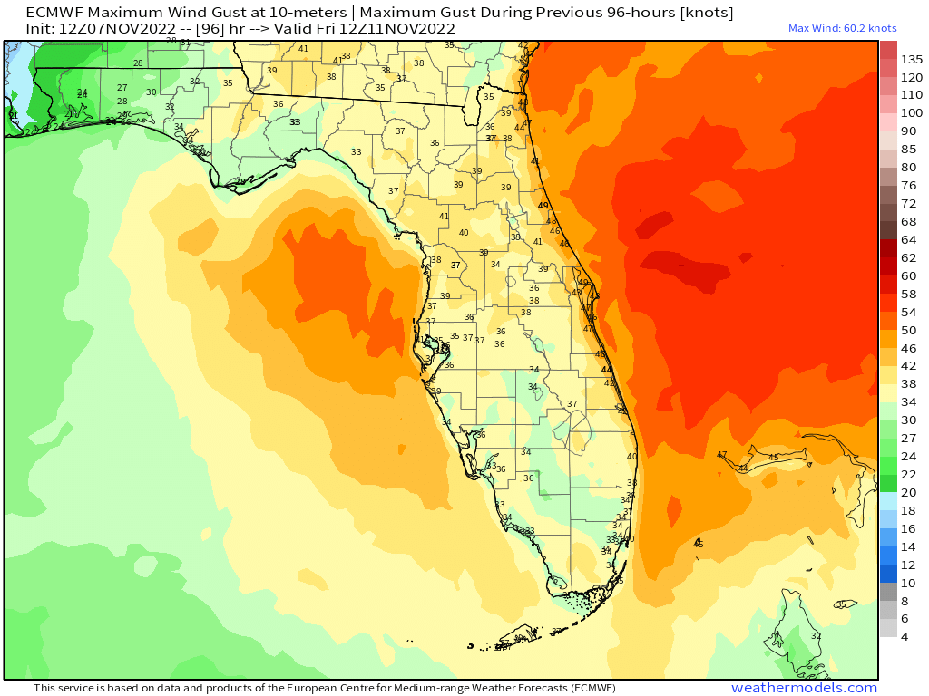
This coastal high surge and wave action will be driven by several days of tropical-storm-force wind gusts out of the northeast. With gales currently extending a whopping 275 miles northwest of Nicole’s center, tropical-storm-force gusts are likely along the coast by late Tuesday from Savannah to South Florida, with gusts increasing to 50 mph or greater in this swath on Wednesday as Nicole approaches. If a convective core develops, a much smaller area of coastal hurricane-force wind gusts may slot in somewhere between Cape Canaveral and Miami overnight Wednesday into Thursday, location TBD.
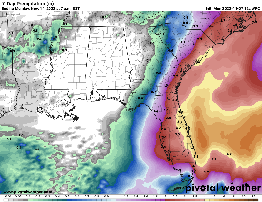
The broader wind impacts are not dependent on this core developing. Inland portions of the Florida peninsula may also see tropical-storm-force wind gusts late Wednesday through Thursday as Nicole’s center tracks onshore, and inland Tropical Storm Watches are in effect for Central Florida. Additionally, general rainfall totals of 2-5” are likely over much of the peninsula through Friday, heaviest east, bringing flash flooding potential to South Florida and East Central Florida, where Ian’s precipitation impacts are lingering.
While as ever the details may change a bit, these surge, wind, and rain impacts are a high confidence forecast for South and East Central Florida. This isn’t an Ian-like situation, but the coastal flooding in particular is going to be nasty along Florida’s East Coast, which has not seen a direct hurricane landfall since 2005. If you are in a low-lying coastal area, it’s time to activate your hurricane plan.
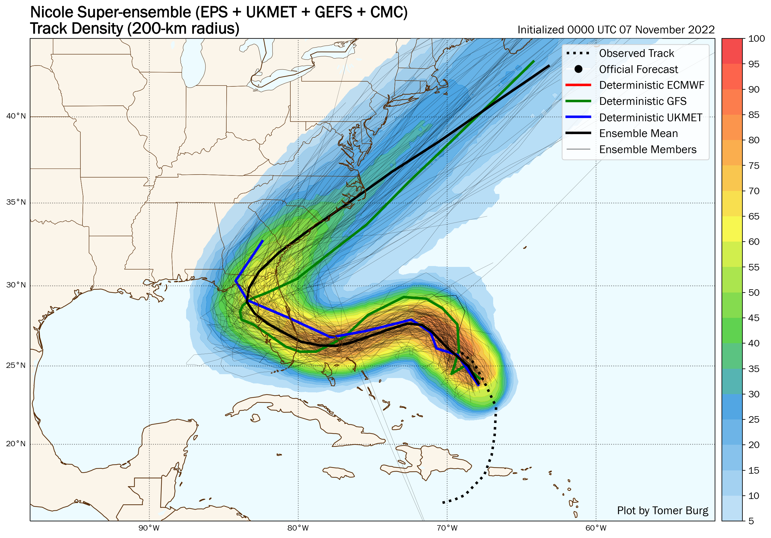
Nicole also may bring significant impacts to West Central and Northern Florida on Thursday and Friday, but forecast uncertainty is higher here. Nicole is likely to cross the Southeast Florida coast late Wednesday or early Thursday moving west-northwest, with a potent cold front approaching from the northwest turning the storm sharply north and northeast on Friday. Depending on how far west Nicole gets, this turn may occur over the peninsula, or Nicole could clip back over the northeast Gulf of Mexico late Thursday and cross the eastern Panhandle Friday.
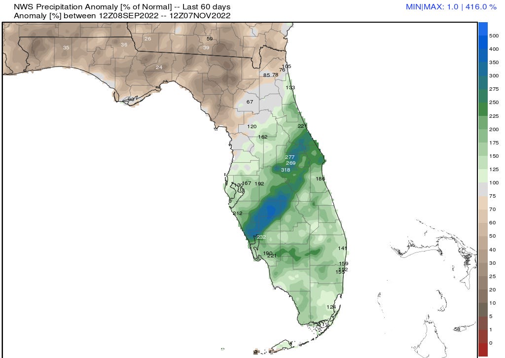
If Nicole remains over land, impacts would be minimal as the storm passes to the Panhandle’s east, likely limited to scattered bands of showers and storms in the Big Bend and breezy weather otherwise. In a way, that would be unfortunate, as much of the Panhandle is now in a severe drought and has seen less than a quarter of normal rainfall in the last two months, so some rain would be beneficial. A fully inland track also means little to no surge from Tampa north into Apalachee Bay.
If Nicole tracks farther west and does edge back offshore, that opens the door for more extensive impacts on the Nature Coast and the eastern Panhandle. Fortunately, water temperatures in the northeastern Gulf were dinged by October’s untimely frost, and are in the tepid mid to upper 70s: marginal at best for fueling tropical cyclones. Thus, re-intensification in the Gulf is not expected.
However, areas that see the circulation center pass to their west in this scenario would be at risk of surge and coastal flooding with onshore wind flow (possibly including Tampa Bay, which saw some flooding during Tropical Storm Eta in November 2020), as well as the potential for tropical-storm-force wind gusts and heavier rainfall. Should the Panhandle see more extensive rainfall coverage, the most concentrated showers and storms would likely arrive on Thursday and depart Friday. The farther west you go in the Panhandle, the lower the likelihood of meaningful impacts, as Nicole’s center is unlikely to track west of Apalachee Bay. It is too soon to offer a confident forecast of Nicole’s impacts in West Central and North Florida, but residents should monitor the situation, especially along the coast.
Overall, just when we thought we were out, Nicole is pulling us back in. As much as it chagrins us to cope with a final, bizarre tropical threat in 2022, Nicole’s widespread water hazards need to be taken seriously, particularly along the East Coast where surge impacts are certain and preparation time is short. We’ll have continuing coverage this week. Keep watching the skies.
A very good and thorough report. I wonder if you can mention in your next post the exact difference between a subtropical and a tropical storm. For example I noticed with Nicole, tropical force winds of 40 miles an hour go out 380 miles from the center which is something I don’t think tropical storms do. The radar is not very well defined this far away from the coast so I can’t tell what the structure in the center actually look like. However Nicole as of 5 AM only had maximum winds of 50 miles an hour so maybe it does not have a very defined center. Thank you again for these very informative updates.