Space Claudette (?) Pinball: WeatherTiger's Weekly Column for June 17th
An irritant-level rainmaking tropical storm is expected for the central Gulf Coast.
Welcome to WeatherTiger’s Hurricane Watch! On Thursday afternoons through October, we’ll be releasing a long-form column digging deeper on current conditions, or some other aspect of tropical meteorology, forecasting, or history if the Atlantic is quiet. Paid subscribers will receive these columns and be able to comment and ask questions, as well as get all of our daily forecast briefings, in-depth forecasts and video discussions during Florida hurricane threats, live landfall coverage, and expanded seasonal outlooks. Free subscribers subscribers will also receive this weekly forecast column. Sign up below to get WeatherTiger’s Hurricane Watch newsletters all season long.
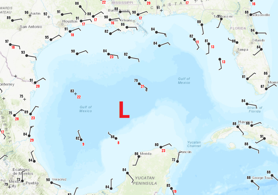
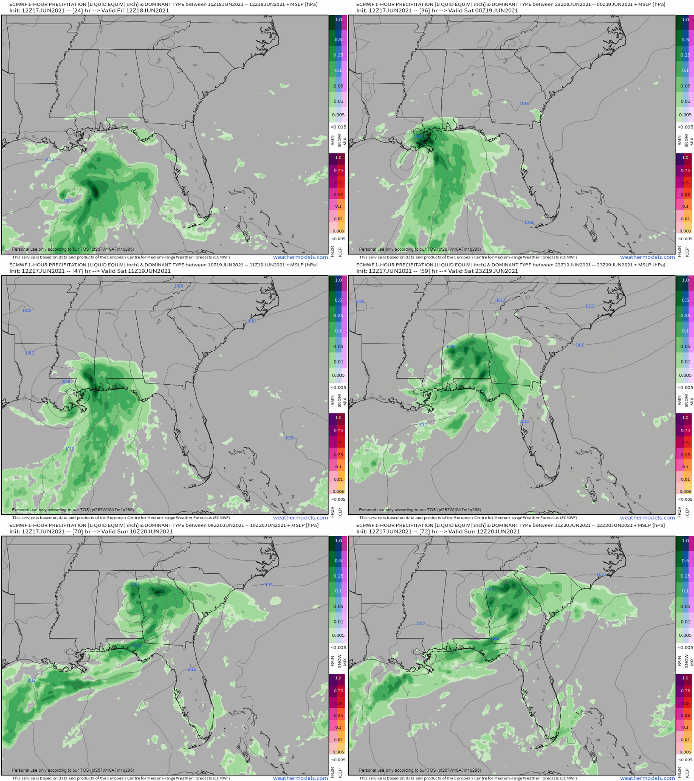
The Gulf of Mexico is finally in the process of coughing up its long-gestating first tropical hairball of the nascent 2021 hurricane season. A weak but large tropical or subtropical storm is expected to reach the central Gulf Coast by early Saturday morning, with the key impact of this system extensive weekend rainfall from eastern Louisiana to the western Florida Panhandle.
As of 5 p.m. Thursday afternoon, the tropical disturbance in question remains too disorganized to have yet received a name from the National Hurricane Center, but the need to hoist Tropical Storm Watches along the central Gulf Coast has led to its designation as Potential Tropical Cyclone 3. Currently, multiple swirls are pivoting about PTC 3’s broad area of turning over the central Gulf of Mexico.
One of those circulations is expected to become dominant in the near future, and the disturbance could become a depression or storm at any point later on Thursday or Friday. An Air Force reconnaissance aircraft is investigating the low-level structure of PTC 3 to determine whether this change is in the process of occurring. If the system acquires sustained winds of at least 39 mph and a well-defined low-level circulation, it will be named Claudette.
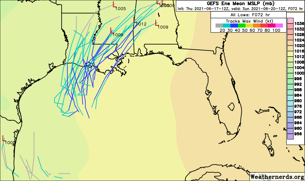
Over the next two days, look for PTC 3 to move north in the general direction of Louisiana, probably reaching land by early Saturday as a minimal subtropical or tropical storm. This is a case in which the forecast focus is not on classification nomenclature, exact track, or maximum sustained winds, but rather the expected heavy rainfall impacts on the central and eastern Gulf Coast and inland South.
Your perspective on this incoming rainfall likely varies based on your location. Over the past 30 days, Pensacola and Tallahassee, as well as surrounding areas of the Florida Panhandle, southern Alabama, and Georgia, have received anywhere from a quarter to half of typical rainfall. When one of the largest natural lakes in North Florida vanishes into a karst pit like a 747 under the cruel tutelage of David Copperfield, you know we could use some rain.
Further west, the situation is reversed. In the flood-sensitive Lafayette-New Orleans-Hattiesburg-Jackson trapezoid of eastern Louisiana and southern Mississippi, three-month rainfall totals are running anywhere from 150 to 300% of average, with some recent localized flash flooding.
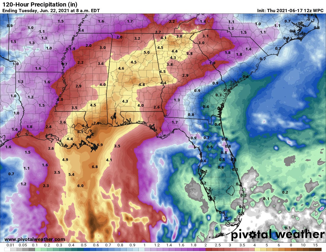
PTC 3 looks to bring rain to both areas where it will be appreciated and unwelcome. Because the storm will be east-weighted due to 20 knots of southwesterly wind shear, the western half of Louisiana is likely to see relatively little precipitation. Rainfall is likely to reach eastern Louisiana, southern Mississippi, and coastal Alabama by Friday evening, tallying 3-6” there with local totals to 8” through early Sunday.
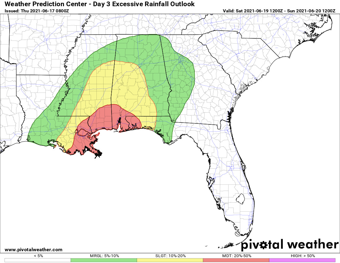
Inland Alabama and the western Florida Panhandle will see the onset of rainfall early on Saturday, with intermittent heavy showers through Sunday afternoon. Accumulations will be a little lighter here, with storm totals of 2-5”. Unlike Sally, PTC 3 will continue to move at a 10-to-15 mph clip northeast across the Deep South through the weekend, limiting the upside potential of this precip. Nevertheless, the highest risks of excessive rainfall on Saturday extend east to roughly Destin, as individual bands may “train” over localized areas and cause flash flooding.
East of Destin into Florida’s Big Bend, look for sporadic bands of storms to kick up Saturday afternoon through Sunday evening, which should not be too different than typical high-coverage days of summer thunderstorms. Look for rain totals through Tuesday to be on the order of a beneficial 1-3” in the Tallahassee area. Keep an eye out for potential threat of isolated tornadoes across the Panhandle. The Florida peninsula is likely to remain mostly drier than normal into next week.
One other underreported risk: rip currents. Coastal winds gusting to low-end tropical storm force between eastern Louisiana and the western Florida Panhandle through Saturday night will lead to dangerous Gulf Coast beach conditions over the weekend. Please heed swimming advisories and water closures; unfortunately, drownings on Gulf beaches occur even in weak tropical storms.
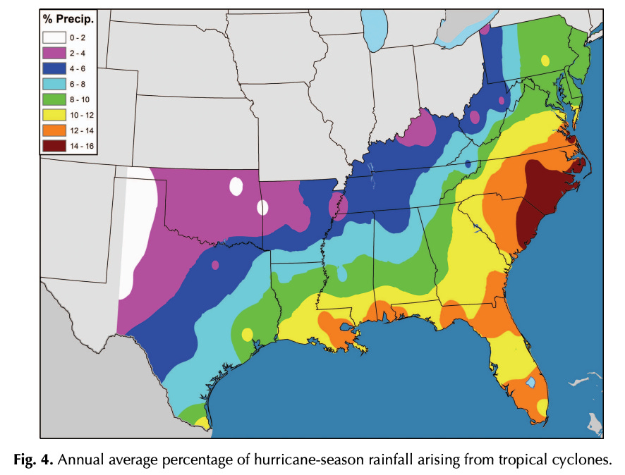
Overall, losing a weekend to a tropical irritant like PTC 3 is annoying. Yet, is important to remember that like vultures, sharks, and octopuses that correctly predict World Cup games, tropical cyclones are a misunderstood but essential part of the natural world. From June to November, 10 to 15% of Florida and the Southeast’s total precipitation comes from named tropical storms and hurricanes. Lacking tropical weather, the entire Southeast would run permanent precipitation and soil moisture deficits; in other words, we’d be hydrologically screwed without the occasional headache.
Anyway, try to keep the weather’s chaotic neutral alignment (shared by rogues, barbarians, and some bards) in mind as you deal with a rainy weekend. Stay safe, and keep watching the skies.


