


Six Packed: The Hurricane Watch for August 18th
Hurricane Hilary poses a major flood risk to the Desert Southwest, while there are no fewer than six areas with some chance of development in the Atlantic through day 10.
Florida tropical threat synopsis: South Florida will see higher rain chances this weekend from a tropical wave. No threats through day 7 otherwise.
Almanac: It’s Friday, August 18th… day 79 of the 2023 hurricane season, 104 days to go. By total storm energy, the season is 14.1%, 27.7%, and 19.5% complete for the Atlantic, continental U.S., and Florida, respectively.
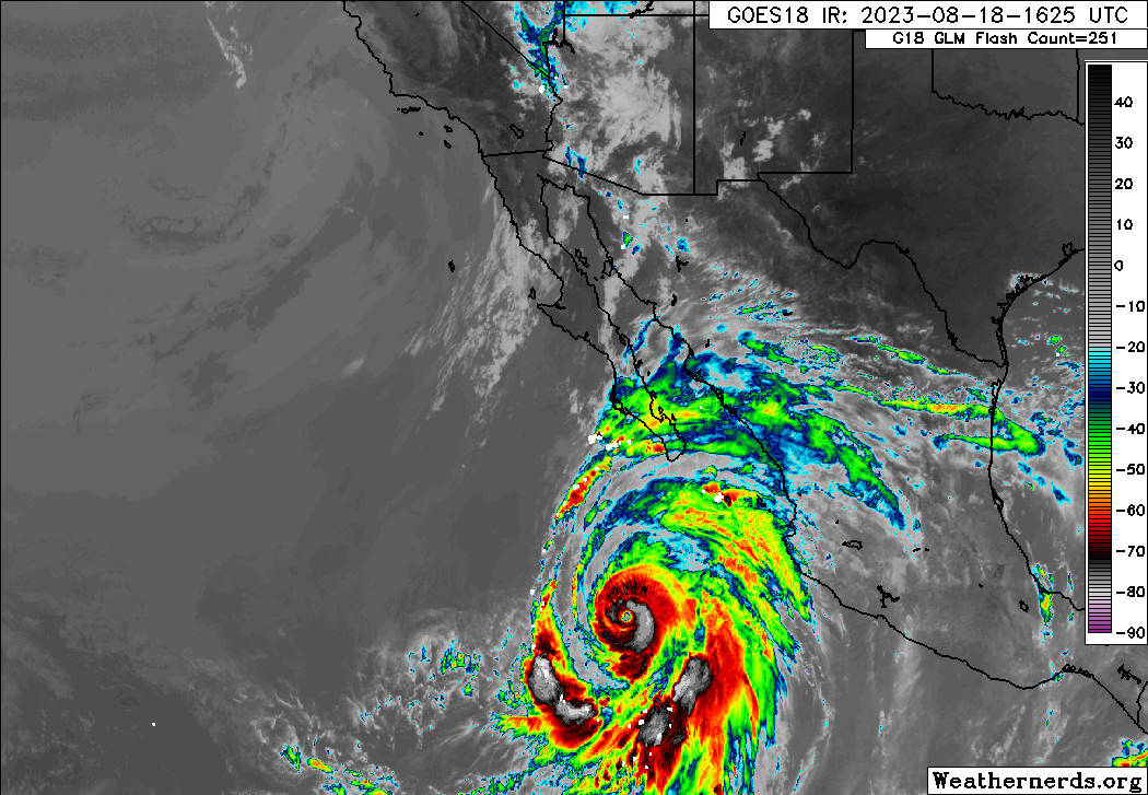
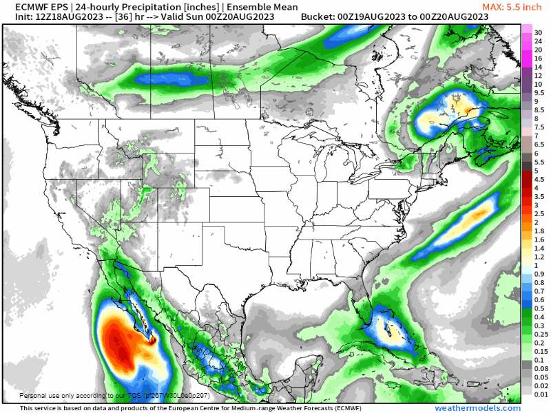
Because this is apparently the part of the newsletter where I cover the Pacific, Hurricane Hilary continues to pose a major rainfall and minor wind threat to southern California and the Desert Southwest. Hilary has peaked at category 4 intensity today, and is forecast to race north along the Baja California and into SoCal as a decaying tropical storm late Sunday into Monday. Tropical Storm Watches are now in effect for the first time ever north to the OC (don’t call it that), and wind gusts of 50-60 mph are possible in the San Diego and L.A. metro areas. The real danger, however, is that 2-10” of rainfall is heading for regions in which that number may be a full year’s worth of average rainfall or more, resulting in widespread flash flooding. Flood Watches are in effect north into Utah and Nevada, and heavy rainfall is likely to begin tomorrow. If you know someone in a low-lying area of the yellow, (especially) red, or (especially especially) purple regions below, encourage them to have a plan to evacuate to higher ground if necessary.
![[Image of WPC Flash Flooding/Excessive Rainfall Outlook]](https://substackcdn.com/image/fetch/f_auto,q_auto:good,fl_progressive:steep/https%3A%2F%2Fsubstack-post-media.s3.amazonaws.com%2Fpublic%2Fimages%2F2e04acee-186a-46f8-ad73-f0c049995426_893x746.gif "[Image of WPC Flash Flooding/Excessive Rainfall Outlook]")
Active Storms: Still none, but…
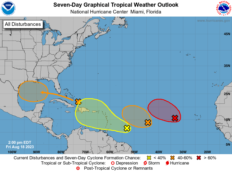
Other Disturbances in NHC outlook, with 2-/7-day NHC development odds:
Invest 98L (Eastern Tropical Atlantic): While there are no fires in the Atlantic, there is a lot of smoke: no fewer than six areas have some shot at developing in the next 8-10 days. The closest to the goal line is probably Invest 98L (red, above; at right, below), a tropical wave between 30-35W. NHC gives it a 70% chance of modest development over the next 2-3 days before dry air and shear get the best of it in the open Atlantic. No threat.
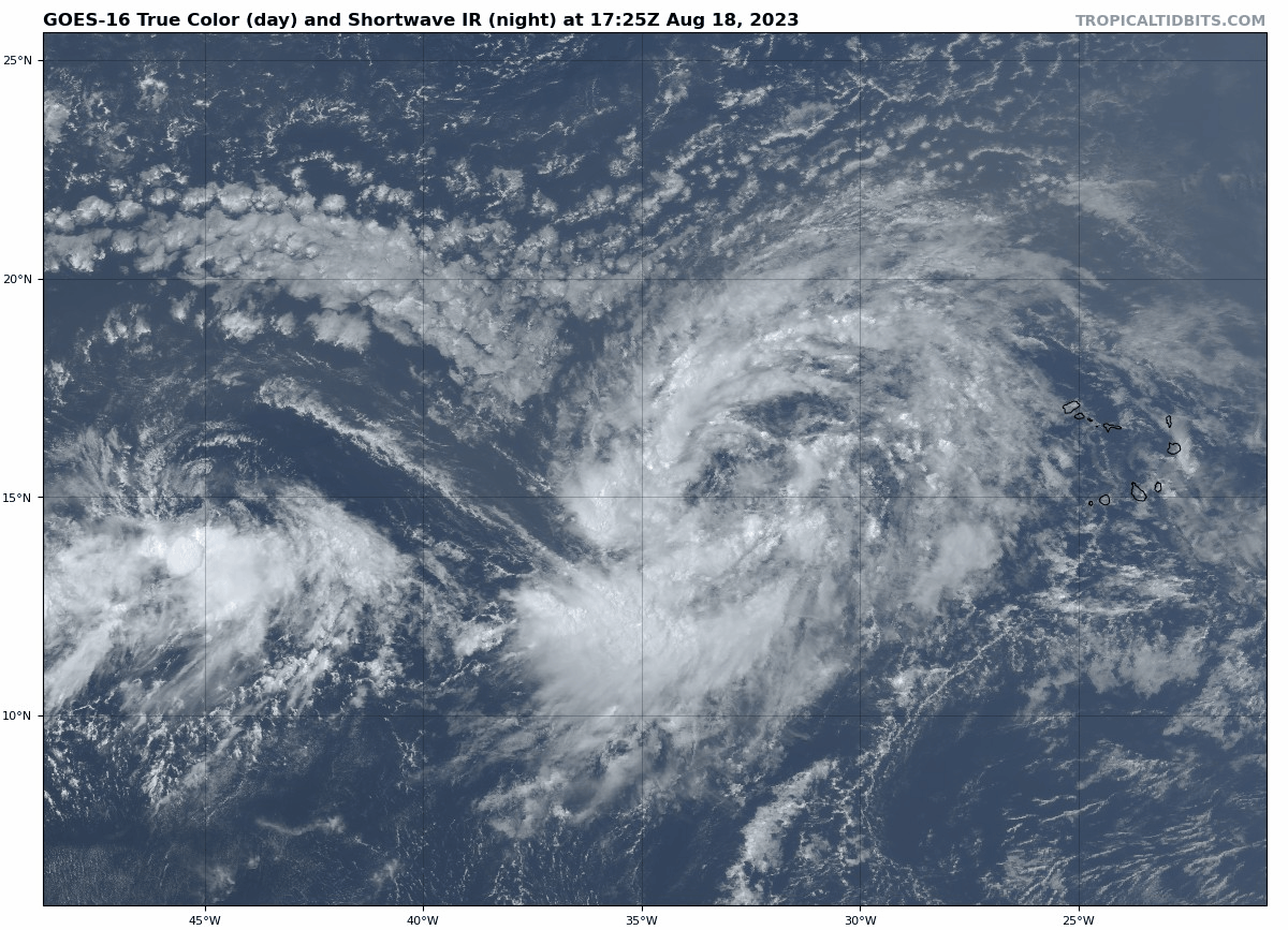
Invest 99L (Central Tropical Atlantic): Invest 99L (at left, above) also has some decent convection and a small circulation with it this afternoon, and the NHC give it a 40% chance of developing in the next two days. However, dry air already covers the northern half of 99L, and is likely to sweep over the southern half of the wave this weekend. No future for this one either.
Western MDR: Yet another wave has been added to the NHC outlook since yesterday, this one between 50-55W and less organized at present. Dry air and shear should have less of an influence on this one over the next week, and the NHC is giving it 10% (2-day) and 30% (7-day) development chances. Look for this wave to cross the Lesser Antilles this weekend and then hook north towards Hispaniola due to an upper-level low in the midweek. What happens to this one down the road isn’t totally clear as both the steering currents and how and where development might shake out are unclear, so it’s worth keeping an eye on, though certainly not of any immediate U.S. concern.
Gulf of Mexico: The only area of interest with a clear shot at the U.S. continues to be a tropical wave over the Bahamas today, which will cross the Florida Straits this weekend and bump up peninsular Florida rain chances. NHC odds of development are now 40% next week, as ensemble models are a little more bullish on wringing a tropical depression or storm out of this prior to reaching the western Gulf Coast on Tuesday or Wednesday. While there may be some sneaky upside potential here if it can organize a little sooner, helpful rains for Texas remain the key impact from this wave.


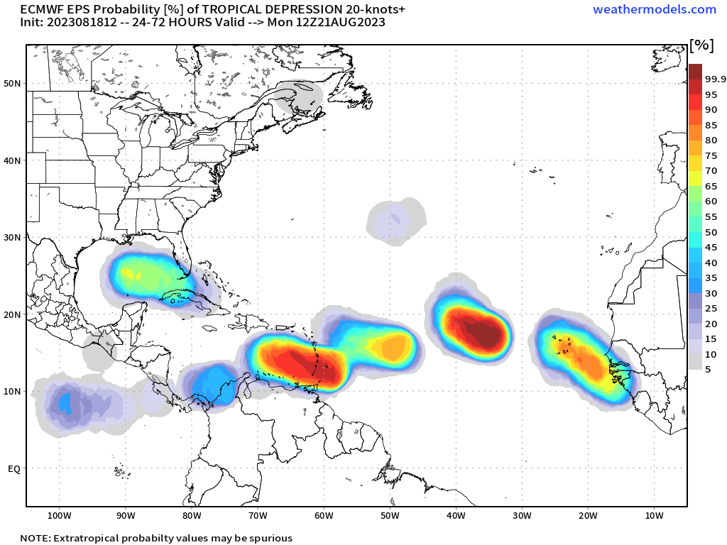
Elsewhere: There’s so much currently on the map that two more features yet to be on the map are going to have to wait their turn for more focus next week. Still, there does remain intermittent support for a Central American Gyre to potentially flare up in 5-7 days, which may trigger Caribbean, Gulf, or eastern Pacific storm formation late next week or beyond. Still nothing specific to watch there. And finally, ensembles do suggest potential for one (or more!) waves yet to roll off the West African coast to have a shot at developing in 4-8 days. Long time to watch those.
In other words… welcome to the most active six weeks of hurricane season.
Next report: Daily update Monday morning.
Have you seen anything about how this will or could impact the Amargosa River that flows under Las Vegas?