


Sam's Club on a Thursday Night: WeatherTiger's Weekly Column for September 23th
Tropical Storm Sam is quickly organizing in the Atlantic and may threaten the Lesser Antilles next week.

WeatherTiger’s weekly column is provided free to all subscribers. To get our complete insights, upgrade to premium for as little as $8 to get daily forecast briefings, in-depth forecasts, videos, and live landfall coverage during U.S. hurricane risks, expanded seasonal outlooks, and the ability to comment and ask questions. Click below to sign up below now.
Two-sentence threat synopsis: Tropical Storm Sam has developed in the east-central Atlantic. Long-range impacts on Florida or the continental U.S. are unlikely, though not completely impossible, and Sam is a much more serious concern for the northern Lesser Antilles, Puerto Rico, and Hispaniola.
It often feels like the true role of the meteorologist in society is not to make predictions, but rather, like a goat released into the wilderness of ancient Judea bearing the iniquities of the people upon its withers, to accept society’s blame when the weather inevitably goes awry.
My standard disclaimer is meteorologists do not exercise a causal influence on the weather, and to disavow personal responsibility for any particular conditions that have ever occurred, throughout the Universe and all possible Universes, world without end.
Exception: late September. Today, I accept your elusive kudo, as if dewpoints below 60⁰ are my accomplishment, for I too am excited that we live in a strange and different world. A world in which sweat can, theoretically, evaporate. And it is glorious, if temporary.
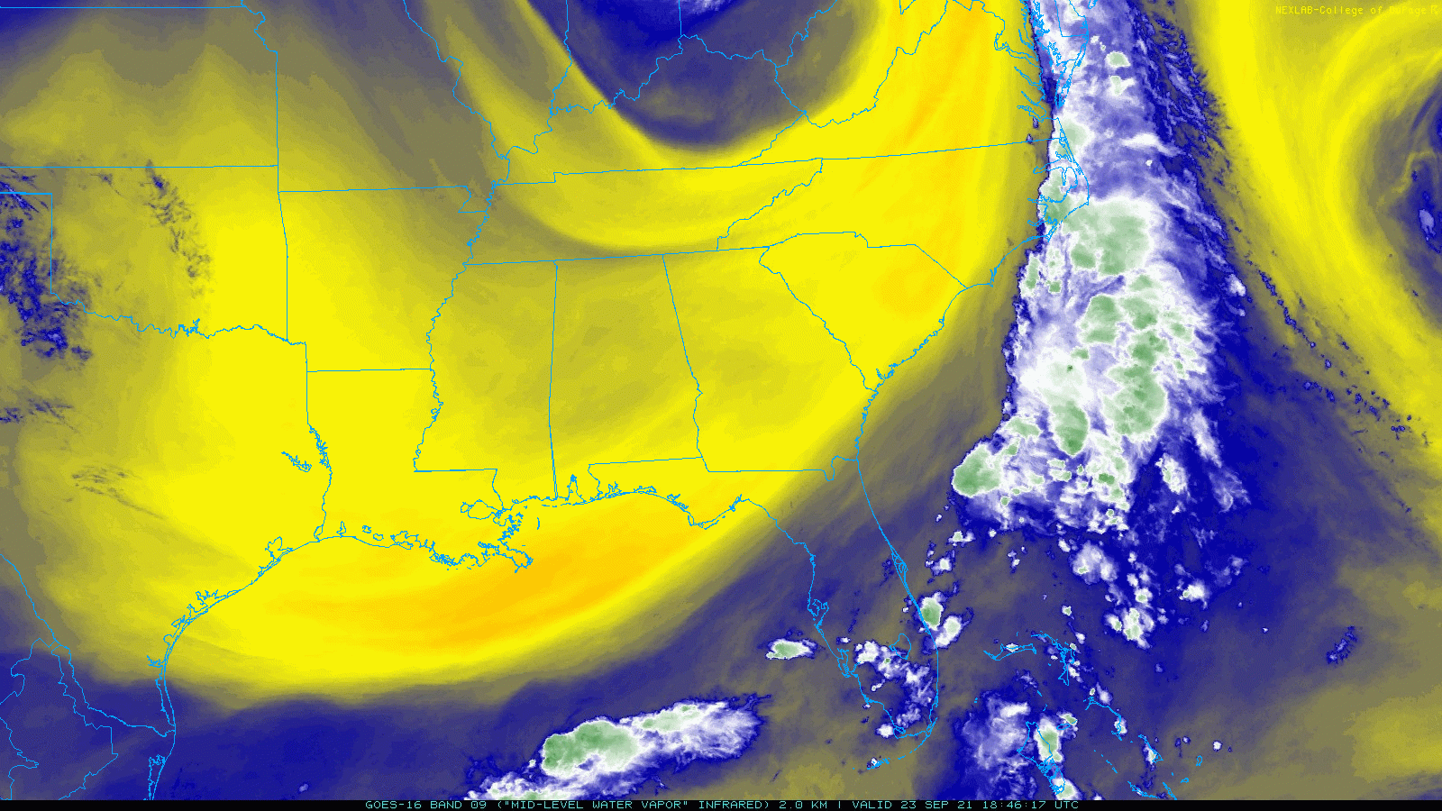
Unfortunately, while the astronomical seasons are changing, hurricane season remains a constant into at least late October. Some good news is erstwhile Tropical Storms Peter and Rose turned in decidedly non-Hall of Fame performances this week, dissipating in the open Atlantic over the last 48 hours.
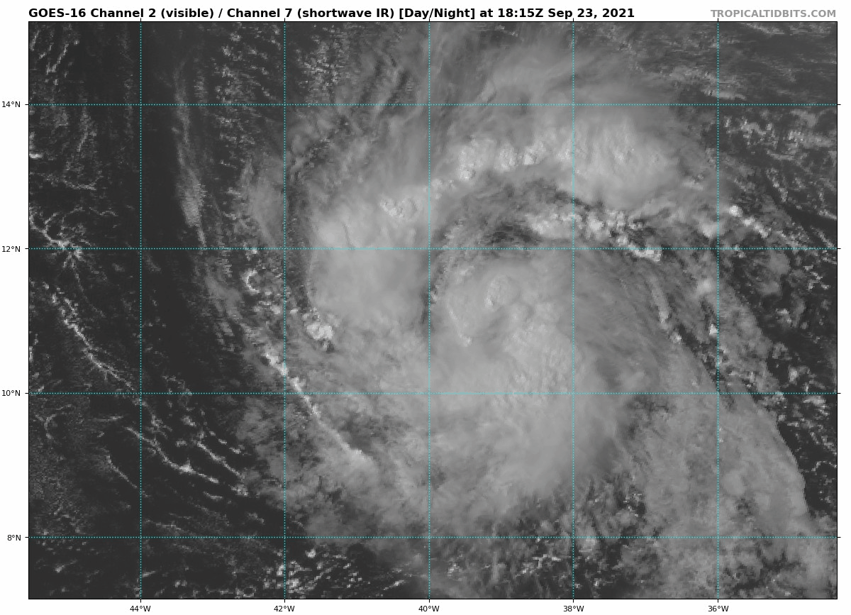
However, Tropical Storm Sam has developed in the east-central Atlantic, and Sam is likely to be a system to keep an eye on deep into early October. Long-range impacts on the continental U.S. are unlikely (though not impossible), but Sam is a much more serious concern for the northern Lesser Antilles, Puerto Rico, and Hispaniola.
As of 5 p.m. Thursday afternoon, Sam is located about halfway between west Africa and the Windward Islands, moving west at about 15 mph, with maximum sustained winds of 60 mph. Sam is well-structured for a developing tropical storm, and wind shear, moisture, and ocean temperatures are all favorable for continued strengthening over the next five days. The official NHC forecast has Sam becoming a Category 3 hurricane by Sunday morning, and Category 4 strength by the middle of next week is a good possibility.
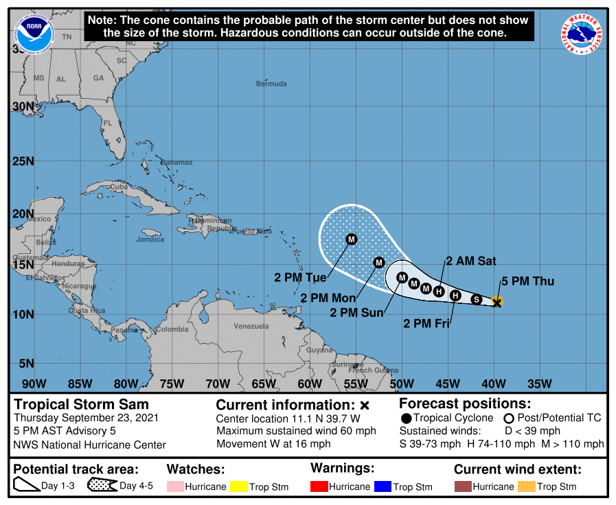
Sam should continue to be steered west to west-northwest for the near future by a ridge of high pressure to the north of the storm, though those currents will slacken over the weekend. Sam will thus move slowly into the middle of next week, and it will be another five or more days before it is in the vicinity of the northern Lesser Antilles. If the general track and intensity forecasts are accurate, Sam is the most serious threat to the northeast Caribbean islands since 2017. (There is no threat to Nicki Minaj’s cousin’s friend’s dog’s former-owner’s barber’s uncle in the southern Caribbean islands, however.)
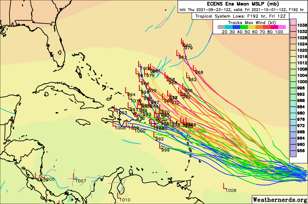
Whether or not Sam crosses the northeast Caribbean is highly uncertain. There is a great deal of spread in model guidance, caused by both forecast intensity and steering regime differences. Fortunately, the more Sam intensifies, the more likely it is to turn northwest in four to six days and mostly miss the islands.
There is also the complication of exactly how far west the subtropical ridging will extend next week. The bottom line is that the northern Lesser Antilles, Puerto Rico, and Hispaniola may not be favored for a direct hit, but are too close to Sam’s possible path for comfort and should be monitoring the situation carefully.
A track over or just north of these islands raises hackles stateside as well, as it would pass through “Hebert Box #1.” Major hurricanes passing through this region, centered on the northern Windward Islands, were noted by former NHC forecaster Paul Hebert to be the Cape Verde storms of greatest eventual risk to Florida.
What’s in the box? Well, some of the worst Florida hurricanes of all-time, including major hurricanes in 1926 and 1928, Donna, David, Frances, and Irma. Of the 30 major hurricanes passing through Hebert Box #1 prior to October, 12 eventually struck Florida.
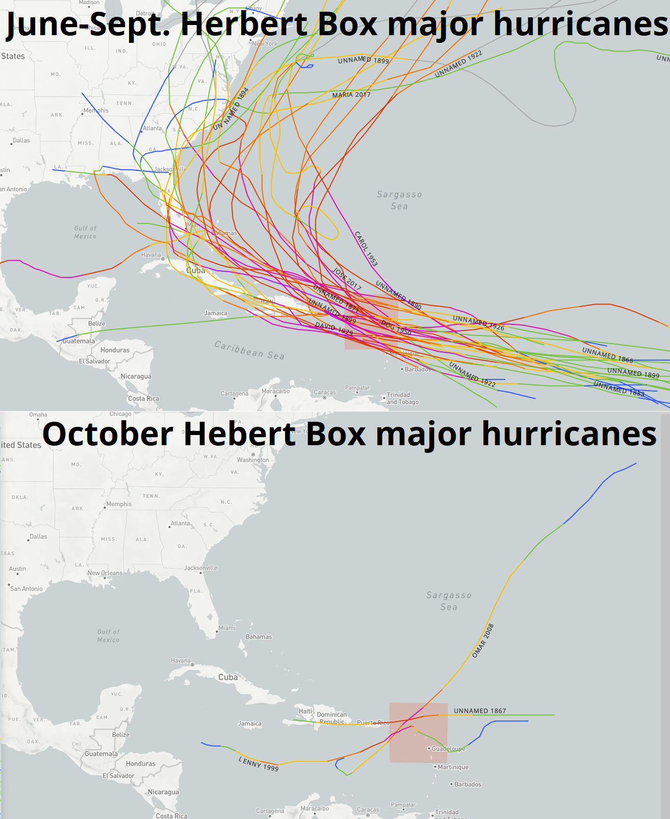
However, Hebert himself noted a seasonal limitation of this method, as changes in typical steering winds reduced its applicability beyond mid-September. None of the 3 major hurricanes to pass through Hebert Box #1 after October 1 came anywhere near Florida.
In the case of Sam, a protective trough or cutoff low near the East Coast is likely to turn the storm north in 8-10 days, well east of Florida. A slight risk to the U.S. East Coast in 10 days or more cannot be ruled out at this stage. Climatologically speaking, it would take an unusual and unlikely combination of events to bring Sam all the way across the Atlantic to the U.S. this late in the year. We’ll keep an eye on it, though.

Otherwise, the Atlantic is quiet, with no other concerning tropical disturbances. Ex-Tropical Storm Odette may recover tropical characteristics in the North Atlantic over the next couple of days, to no import. Another tropical wave could develop by the middle of next week in the eastern Atlantic, though any such system would be virtually certain to eventually turn north in the open Atlantic. There is no indication of any potential U.S. concerns in the vicinity of late-season Hebert Box #2 in the western Caribbean; more on that box in a future column.
In short, while I continue to not control the weather, I also don’t see any cause in the short-term for a 1984-style Two Minutes Hate to be directed at your friendly neighborhood meteorologist. Enjoy fall and keep watching the skies.
Next update: Paid subscribers will receive a daily briefing tomorrow.