Sam Cooks: WeatherTiger's Weekly Column for September 30th
Reviewing October hurricane climatology as Sam and Victor pass harmlessly out-to-sea.
WeatherTiger’s weekly column is provided free to all subscribers. To get our complete insights, upgrade to premium for as little as $7.99 to get daily forecast briefings, in-depth forecasts, videos, and live landfall coverage during U.S. hurricane risks, expanded seasonal outlooks, and the ability to comment and ask questions. Click below to sign up below now.
Two-sentence threat synopsis: Hurricane Sam and Tropical Storm Victor are not threats to the continental U.S. The western Caribbean is worth watching in 8-12 days, but there remains no specific threat at this time.
Hurricane season lasts six months, but those months are not created equal. Historically, September is the least equal of them all, accounting for a little less than half of both overall Atlantic hurricane and Florida landfall activity.
Thus, the passing of this September with just one modest tropical storm and one minimal hurricane U.S. landfall to its name should be viewed as light punishment. However, like a three-foot skeleton from Family Dollar standing guard over suburban Bermuda grass, October looms at the end of Florida’s hurricane season.
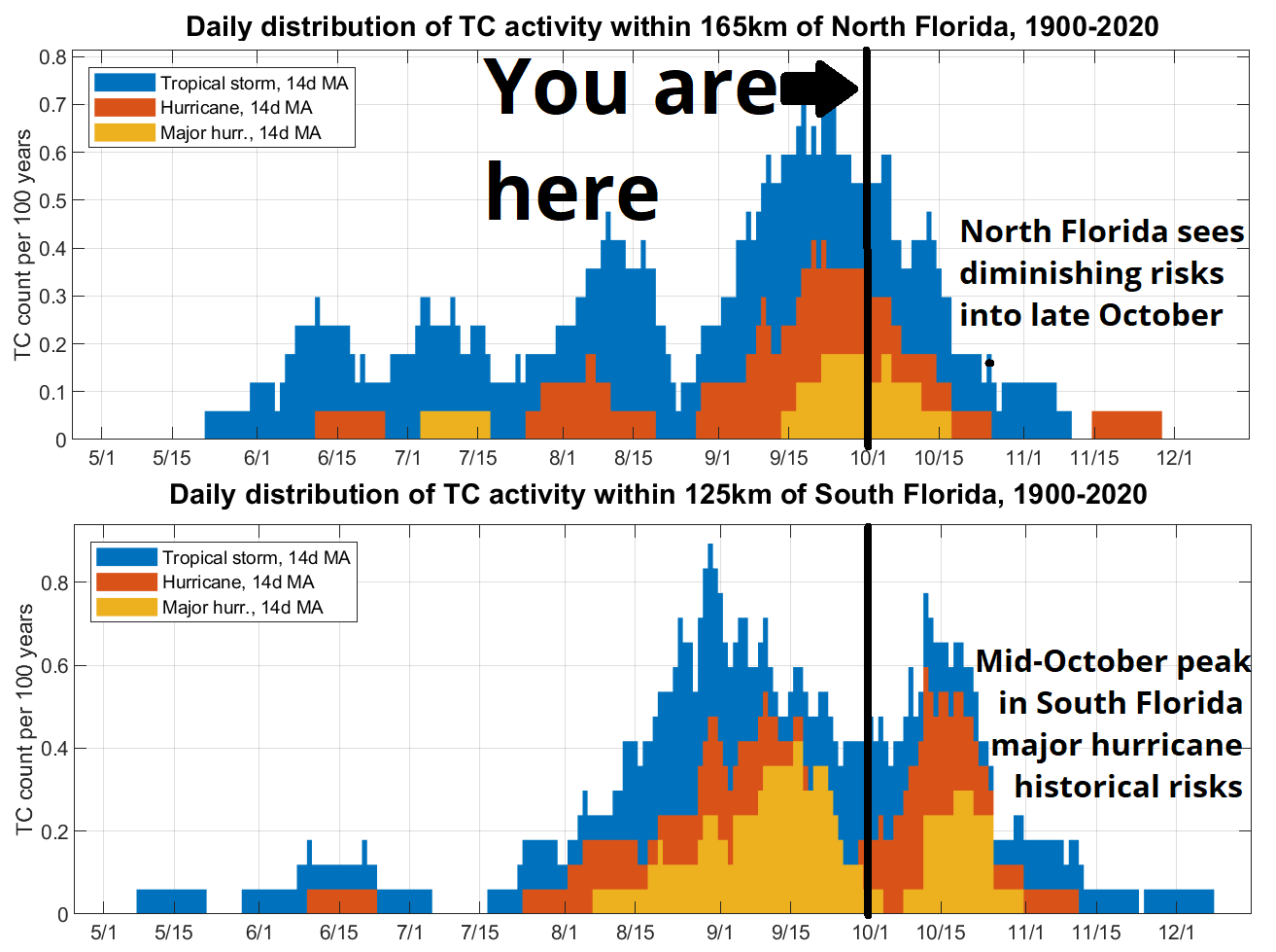
Climatologically, about one-quarter of historical storm activity occurs after October 1. In Florida, these late-season storm risks skew south, especially in the second half of the month. For North Florida, there is a steep drop-off in the number of tropical storm and hurricane landfalls occurring beyond mid-October; in fact, Michael (Oct. 10) is the latest in the year a Category 3 or stronger hurricane has ever made landfall in the Panhandle. So, while getting through the next two weeks does not guarantee safety for the remainder of the year, it does mean a lot.
For South Florida, you’ve got another thing coming, just like Judas Priest said. After a historical lull in hurricane action for the southern peninsula between roughly September 20 and October 10, there is a secondary apex in hurricane landfall frequency, rivaling early September’s primary peak, around October 20 and receding by the end of the month. October hurricanes, like Wilma, typically approach Florida from the southwest after developing in the western Caribbean.
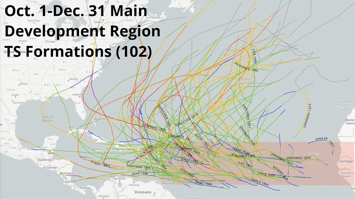
The Caribbean remains quiet today, and is likely to remain so for another precious week of running clock for North Florida. The eastern Atlantic that has had a late-season renaissance this week, which is a fantastic time for a renaissance. Of the 102 named storms since 1851 that have traversed the eastern Tropical Atlantic on or after 10/1, only 4 have ever gone on to impact the continental U.S.
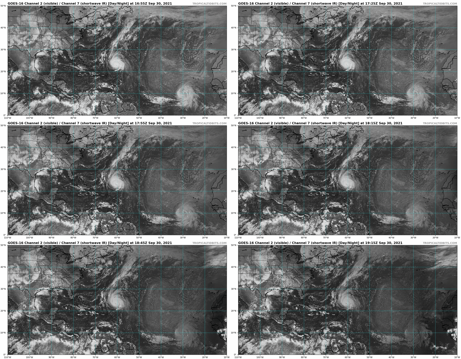
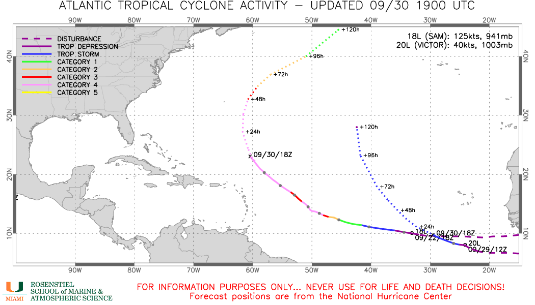
Currently, Hurricane Sam continues to continue across the open Atlantic at formidable Category 4 intensity. After peaking over the weekend as a near-Category 5, Sam has fluctuated between Category 3 and 4 strength this week. It will likely do so for another day or two before starting to weaken as it passes east of Bermuda this weekend. Sam’s only impact on the U.S. will be another round of heavy surf for much of the East Coast, and we’ll bid it adieu next week like a seven-foot Target skeleton waving from a porch Adirondack chair.
Tropical Storm Victor is also churning just west of the African coast, after developing Wednesday farther south than all but two tropical storms in the Atlantic historical record. If this were early September, that would be a concern, but Victor is a lock for an early recurve into the eastern subtropical Atlantic and is no threat any landmass. Victor may strengthen to a hurricane this weekend over open waters, before weakening as it turns northeast early next week.
Keen observers of the alphabet may notice that Victor is close to the end of it. Just one more moniker, Wanda, remains on the standard twenty-one name list for 2021. When, not if, storm number twenty-two forms, that name will be drawn from a new supplemental list of names that replaced the Greek alphabet as a backup this year, and runs from Adria to Will.
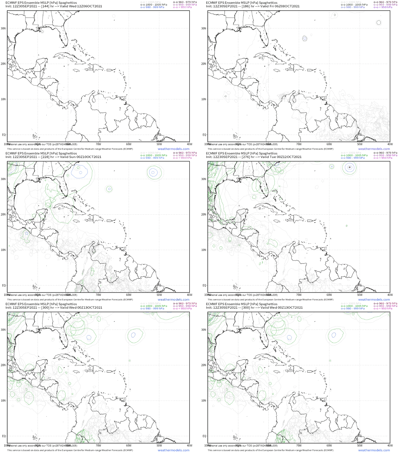
There is no sign of Wanda or Adria on the weather maps yet, and the Atlantic is likely to be quiet other than Sam and Victor for the next five to seven days. A cutoff upper-level low over the southern U.S. means unfavorable shear in the western Caribbean through the first week of October. As this cutoff clears out in the second week of October, the western Caribbean could become more favorable for eventual tropical development. The model ensembles’ signal for possible development in 10-12 days is a little stronger today than yesterday, though still vague. It is far too early to speculate on where such a system might track, if indeed one develops.
In short, as October begins, the signs of change are everywhere. Billie Joe Armstrong can be safely awakened. Dog the Bounty Hunter roams Florida’s great State Park system like a capricious zephyr. Twelve-foot tall deluxe skeletons costing $299.99 at Home Depot fleck the dusk horizon. And while a quiet week is ahead in the Tropics, we’ll continue to monitor the southern Caribbean for any signs of trouble as October gets underway. Keep watching the skies.


