Pacific Cooler: WeatherTiger's Weekly Column for July 15th
The Pacific is likely to tip into hurricane-supporting La Nina conditions by early fall.
WeatherTiger’s weekly Thursday column is provided free to all subscribers. To get our complete storm coverage, upgrade to premium for as little as $8 to get daily forecast briefings, in-depth forecasts and videos during Florida hurricane threats, live landfall coverage, expanded seasonal outlooks, and the ability to comment and ask questions. Click below to sign up below now, or to share the Hurricane Watch with your friends and family.
Pacific Cooler: the ideal flavor of Capri Sun slush to enjoy in the back of a Pontiac Trans Sport on the way home from soccer practice, but a bad omen when it comes to Atlantic hurricane season.
While the Atlantic Basin remains currently free of tropical activity and will stay that way for the next week to 10 days, trends towards declining ocean temperatures in the Pacific are more likely to lead to an active peak of Atlantic hurricane season in September and prolong active conditions into October.
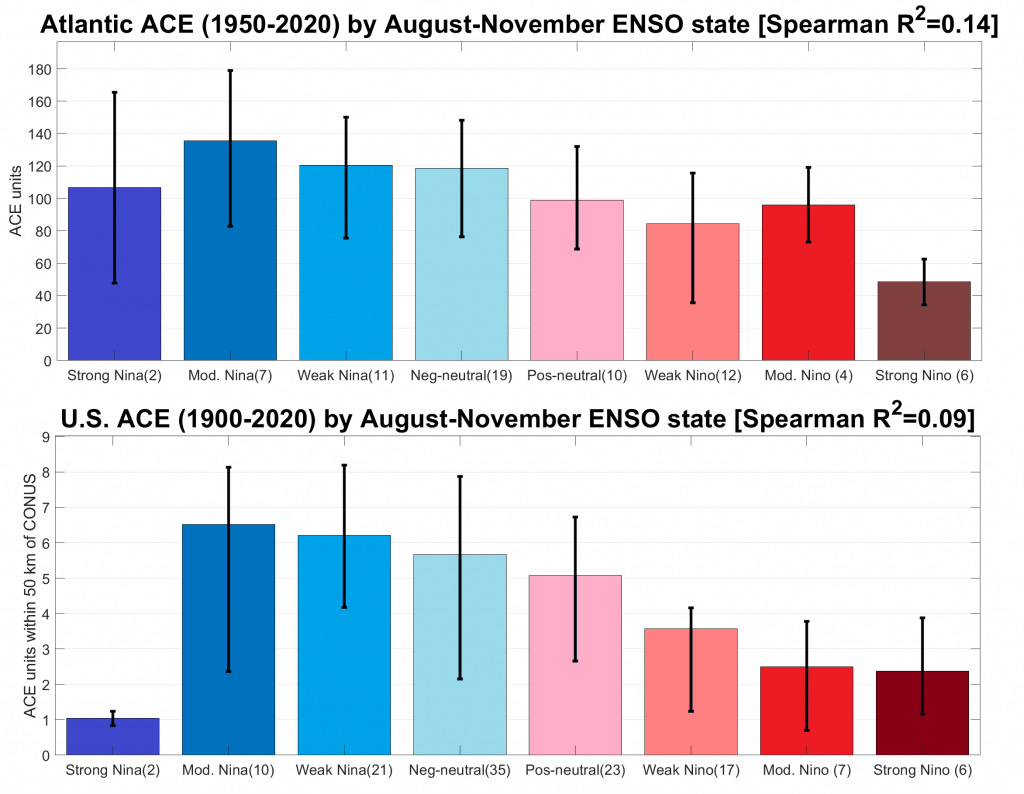
Those changes shift the odds of whether a La Niña event will redevelop in the upcoming months. In a La Niña, the waters of the central and eastern Equatorial Pacific Ocean are colder than normal, which has major implications for global weather patterns including Atlantic hurricane activity.
El Niño, La Niña’s somewhat better-known counterpoint and Chris Farley alter ego, is marked by warmer than average ocean waters in the same region. Collectively, these highly influential cold and warm phases are known as El Niño-Southern Oscillation (ENSO).
You might recall that late summer and early fall 2020 witnessed the development of a moderate La Niña, which peaked over the winter. In classic style, the 2020 La Niña suppressed unfavorable wind shear over the western Atlantic, particularly in the latter half of the hurricane season. In concert with much warmer than average ocean temperatures in the Caribbean and Gulf of Mexico, La Niña thus led to a record-smashing five major hurricanes in October and November 2020.
La Niña 2020-21 ended in the first half of this year, and the Pacific is currently idling in neutral as ocean temperatures near the Equator are close to average. The future trajectory of ENSO is notoriously difficult to predict in the spring during neutral conditions, and our seasonal outlooks so far for the 2021 hurricane season have highlighted more uncertainty than usual due to the Pacific’s lack of direction.
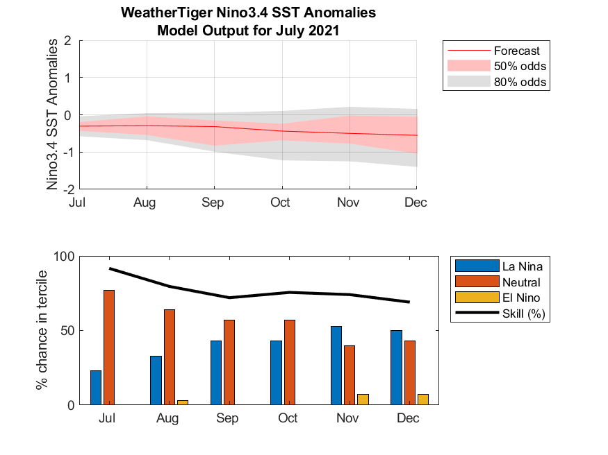
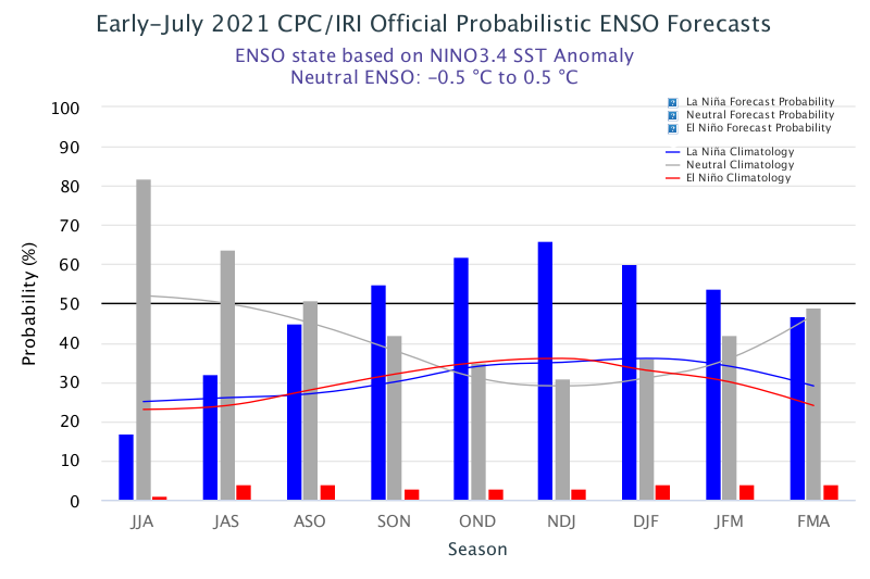
In recent weeks, however, the Pacific appears to be picking a lane for the second half of 2021, and it is not good news for Florida. Equatorial sea surface temperatures are starting to fall, and new projections including WeatherTiger’s own in-house ENSO model now are in good agreement on a likely return to weak La Niña conditions this autumn.
Because model guidance is in consensus with the observations, last week the National Weather Service issued a “La Niña Watch” for fall 2021. Just as a Hurricane Watch indicates that hurricane conditions are possible but not certain in the watch area, in this case a La Niña Watch means there is roughly a two-thirds chance of La Niña conditions developing in the Pacific by the end of the year.
WeatherTiger will be issuing a full refresh of our hurricane season forecast in early August, which will cover expected ranges of tropical cyclone activity and discuss how steering current patterns could make 2021 more or less risky for Florida. In the meantime, this week we ran a mini-update of our models using the latest ocean and atmospheric data, in order to see whether the ENSO trajectory changes would have a major impact on our forecast expectations.
The results are a little anti-climactic, in a good way: WeatherTiger’s predictive algorithm didn’t budge, remaining less bullish than other seasonal forecasts but still calling for an active hurricane season. The most likely outcome for 2021, including the five storms that have already occurred, is around 145 units of accumulated cyclone energy (ACE), against an average of 100 over the last 50 years.
There is roughly a 50% chance of final counts landing in the 105-180 ACE, 17-22 named storms, 7-10 hurricanes, and 3-5 major hurricanes ranges. That corresponds to 5%, 30%, and 65% odds of below, near, or above normal hurricane seasons, respectively, relative to 1971-2020. July ocean and atmospheric conditions are an even better predictor of net seasonal activity than May and June data, so our next update will go a long way to further confirming these expectations.
So, while our topline numbers have changed little since early June, forecast uncertainty is diminishing. The odds of a weak La Niña in the second half of the hurricane season are rising, but this supportive influence on storms could still be partially offset by milder Tropical Atlantic ocean temperatures than in 2020. Overall, keep in mind that the inactive short-range outlook for Atlantic tropical activity belies a probable busy peak season ahead this week as you sip your coolers and keep watching the skies.
Next update: Our regular daily briefing will resume tomorrow for paid subscribers.


