Nicholas Rage: WeatherTiger's Hurricane Watch for September 13th
Tropical Storm Nicholas will bring a serious flood threat to coastal Texas and western Louisiana over the next three days.
WeatherTiger has written daily-plus posts covering a ridiculous almost-50 tropical storms and hurricanes in the last 16 months. This week, our blog has been selected to share the front page of Substack.com with Salman Rushdie. (Check it out.)
With so many new subscribers and the Tropics popping this week’s daily blogs are free to all subscribers. We’ll be tracking Nicholas, monitoring an Atlantic wave that has a chance of being long-term U.S. threat, and on guard for any other September mayhem.
We hope you enjoy our coverage. If you find it valuable, please consider upgrading to a paid subscription to continue receiving our daily reports, be able to comment and ask questions, and get lots of subscriber extras. As always, thanks for reading the Watch.
Two-sentence Florida tropical threat synopsis: There are no short- or medium-term tropical risks to Florida, as TS Nicholas will pass to Florida’s west and another disturbance to the east in the next 5 days. At extended (~2 weeks) range, keep an eye on a tropical wave currently in the far eastern Atlantic, but this is still a long way off.
Almanac: It’s Monday, September 13th… day 104 of the 2021 hurricane season, 79 days to go. By storm energy, the season is 51.4% complete as a whole, 58.5% complete for the continental U.S., and 53.6% complete for Florida.
As we roll into the second half of September, the focus of U.S. landfall risks start to shift back west across the Gulf Coast, with another cluster of major hurricane landfalls across South Florida from the latter part of the “Cape Verde” long tracker season.
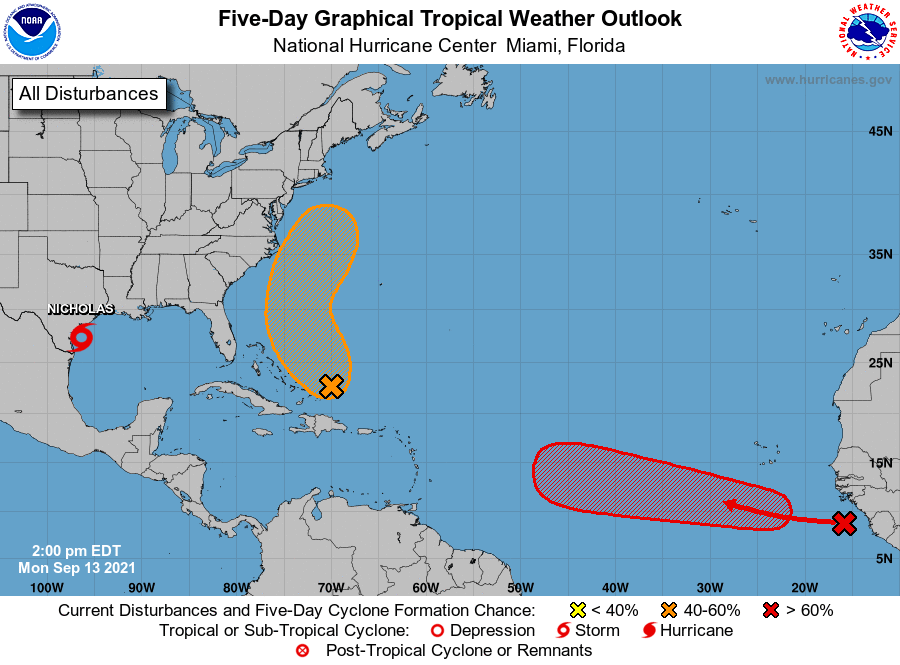
Active Storms: Tropical Storm Nicholas is closing in on coastal Texas this afternoon, with maximum sustained winds as of the NHC 5 p.m. advisory up to 65 mph. Nicholas continues to move north-northeast at a steady 12 mph clip, and will come ashore east of Corpus Christi and west of Houston late tonight or early tomorrow morning. A little more strengthening is possible, but shear should cage Nic’s intensity under Category 1 hurricane status before landfall.
As has been the consistent forecast, the key threat with Nicholas will be heavy rainfall causing flash flood potential in eastern Texas and western Louisiana. After landfall, Nicholas will only move slowly northeast through Thursday, leading to the potential for widespread 5-10”+ rainfall. These are flood susceptible areas, and portions of eastern Texas and southern Louisiana are at moderate to high risk of flash flooding. If you are in the red or purple-highlighted areas above, you especially need to continue to monitor local emergency management information sources through yet another slow-moving soaker.
Current disturbances in NHC outlook, with 2-/5-day NHC development odds:
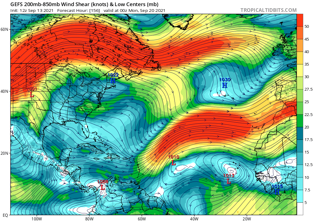
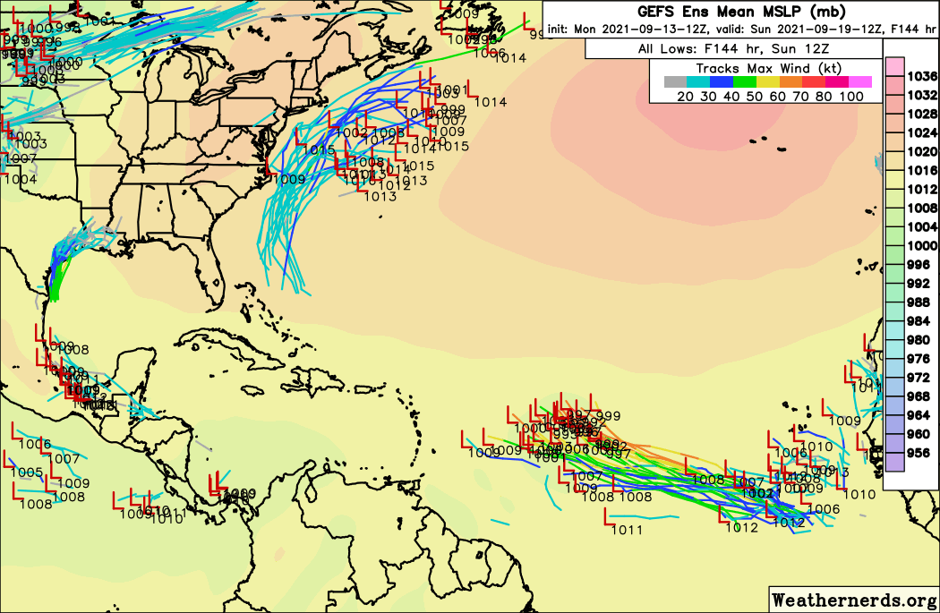
Invest 95L in the Eastern Atlantic (30/80%): A tropical wave coming off Africa today has a good chance of development in 3 to 6 days, and will initially move mostly westward unlike other east Atlantic waves this year. Invest 95L may be in the general vicinity of the Lesser Antilles in about a week, at which point the system could begin to encounter some unfavorable shear (see GFS Ensembles for Sunday night, below) and struggle.
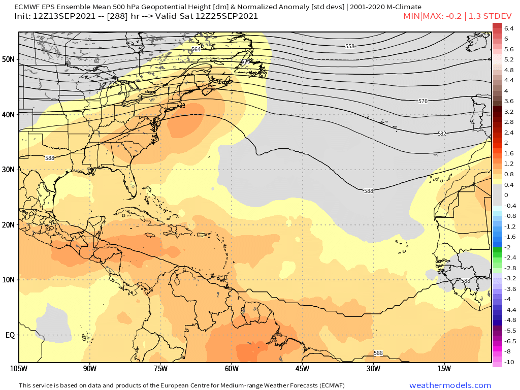
Should 95L both develop and survive the shear gauntlet, a ridge over the U.S. East Coast theoretically leaves the steering pattern open for a potential eastern U.S. threat in a little under two weeks (below). Obviously, a lot of things have to go wrong for that to happen, and any U.S. risks are slight at this range. It is worth keeping an eye on 95L in the meantime, though, given September climatology.
Southwestern Atlantic (10/50%): A tropical wave currently east of the Bahamas is starting to generate some convection today, and could enter a slightly more favorable environment for development midweek as it turns to the northwest and north. While this system will remain well east of Florida and is most likely to stay east of the Carolinas as well, look for some potential rain chances along the upper Southeast Coast later this week. This disturbance may also hang around east of the mid-Atlantic through early next week, and its ultimate fate is unclear.
Elsewhere: No other active disturbances or significant future threats.
Next report: Next report tomorrow afternoon. Until then, keep watching the skies.


