Models Help People: WeatherTiger's Weekly Column for July 22nd
Watching the Southeast Coast, and ranking computer models as we do.
WeatherTiger’s weekly Thursday column is provided free to all subscribers. To get our complete storm coverage, upgrade to premium for as little as $8 to get daily forecast briefings, in-depth forecasts and videos during Florida hurricane threats, live landfall coverage, expanded seasonal outlooks, and the ability to comment and ask questions. Click below to sign up below now, or to share the Hurricane Watch with your friends and family.
In 1976, British statistician George Box wrote, “All models are wrong, but some models are useful.” Two decades later, the most critically acclaimed, Pulitzer Prize winner Nas proclaimed “model data, [a] big threat to a lot of you haters.” (Ok, Nas said “model dater,” but let me have this one.)
From a meteorological perspective, both statements are true. Computer models have been an instrumental tool in the continual march of improved forecasting skill in the last several decades. On the other hand, when a major hurricane threatens, less-than-reputable outlets with names like Uncle Kevin’s Weather Basement and CAPSLOCKNEWS dot FREEDOM threaten Floridians’ tenuous sanity by cherry-picking frightening model clickbait.
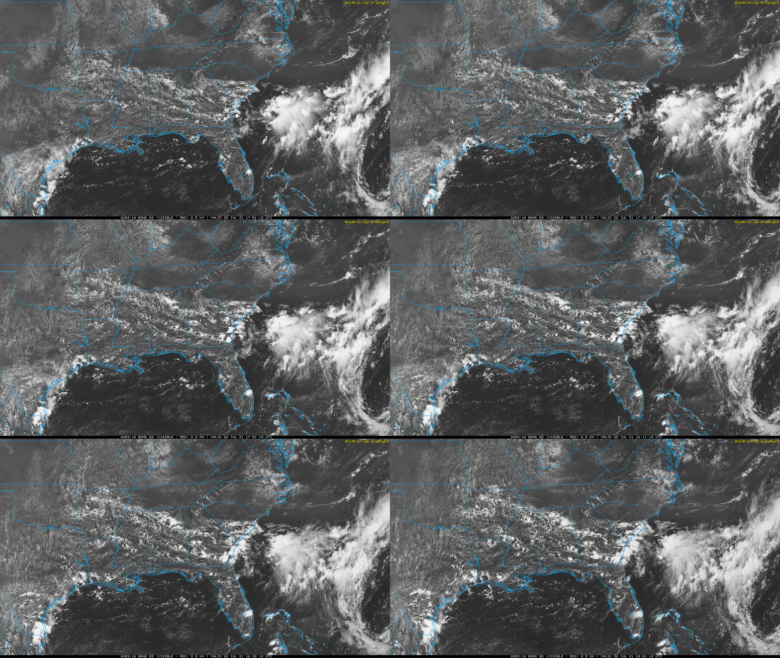
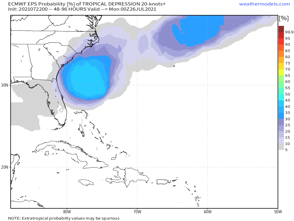
With the Tropical Atlantic currently in a mid-summer lull, let’s have a little chat about models. The only area to watch in the upcoming week is some rotation along an old frontal boundary east of Florida and south of the Carolinas. As this system parks near the Gulf Stream over the weekend, development of a tropical depression or weak tropical storm is an outside possibility.
However, mid-level moisture is limited and shear is brisk, so there is almost no chance of anything worth worrying about forming. The main disturbance may scrape back along the Southeast Coast as it weakens by Monday, while another disorganized piece of ex-frontal vorticity may loop into the eastern Gulf and increase rain chances there next week. Otherwise, the Tropical Atlantic is dusty, quiet, and likely to stay that way through the end of July.
Meteorologists can make predictions like that with confidence thanks to computers’ incredible facility with repetitive math problems. In a nutshell, computer models use information about current weather conditions and the physics equations that describe how fluids behave to estimate how the atmosphere will change with time. These models are capable of simulating hurricanes, though many make rough approximations of the complex cores of storms.
Some forecast models are run as ensembles, in which many versions of the same model are made by slightly tweaking initial weather conditions — for example, shifting the starting location of a hurricane by a few miles. Small differences can have big long-term impacts, so the way the ensemble members spread out with time gives a sense of forecast uncertainty, as well as decreasing net error.
The output of the various computer models and ensemble members is often simplified into a herd of attractive lines showing possible hurricane tracks, colloquially known as "model spaghetti."
Yet there is more to modeling (and life) than being really, really ridiculously good-looking, and not all spaghetti is equal. Some are haute cuisine, some are Fazoli’s, and some are boxes in a dark corner of your pantry that expired in 2007. There have been notable upgrades to some models recently, so here are updated 2021 power rankings for the hurricane modeling world:
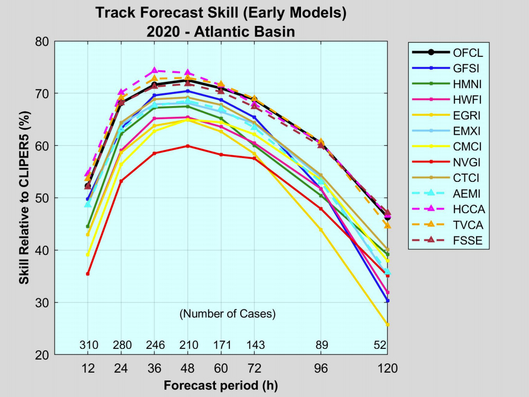
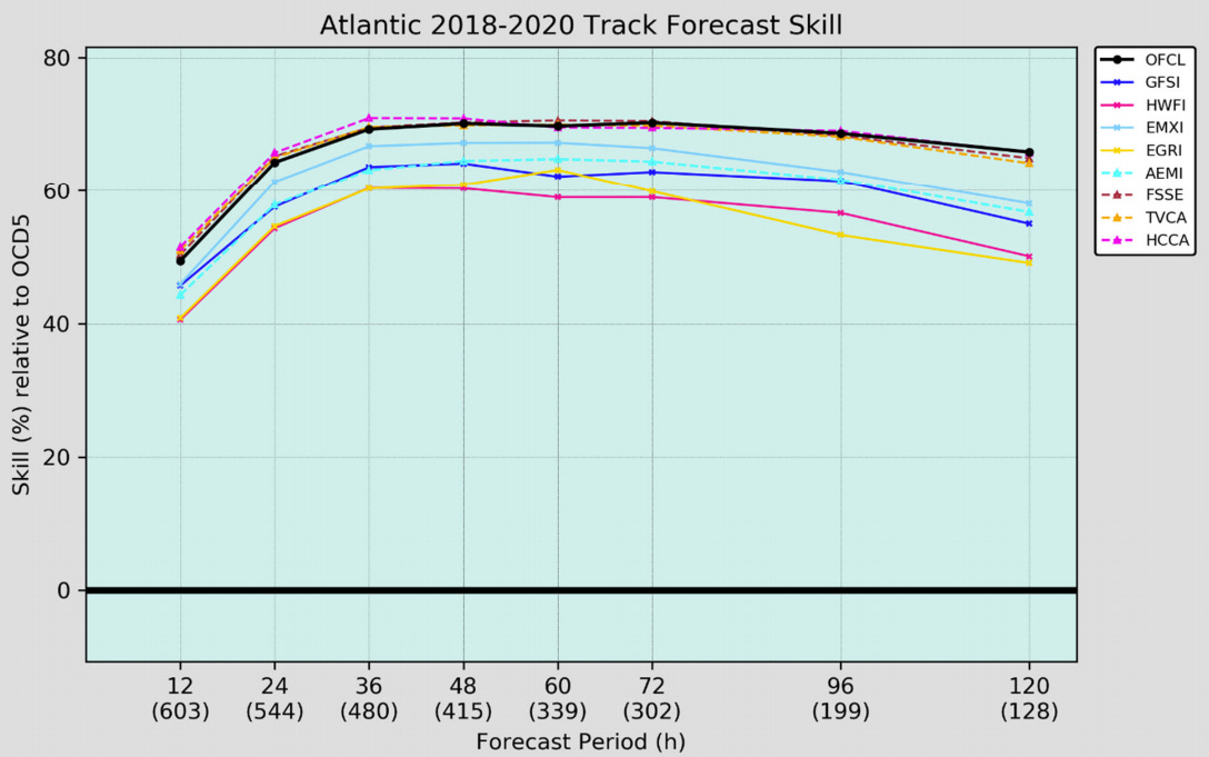
1. European (ECMWF). The predictive skill of the European model for global weather patterns remains due to better ways of incorporating observations and superior processing power. For hurricanes, the Euro is the least prone to spurious storm development, and it has the best average model track skill over 2018-2020. Still, it is fallible, and has been behind the curve with the later storms of 2020 and Hurricane Elsa.
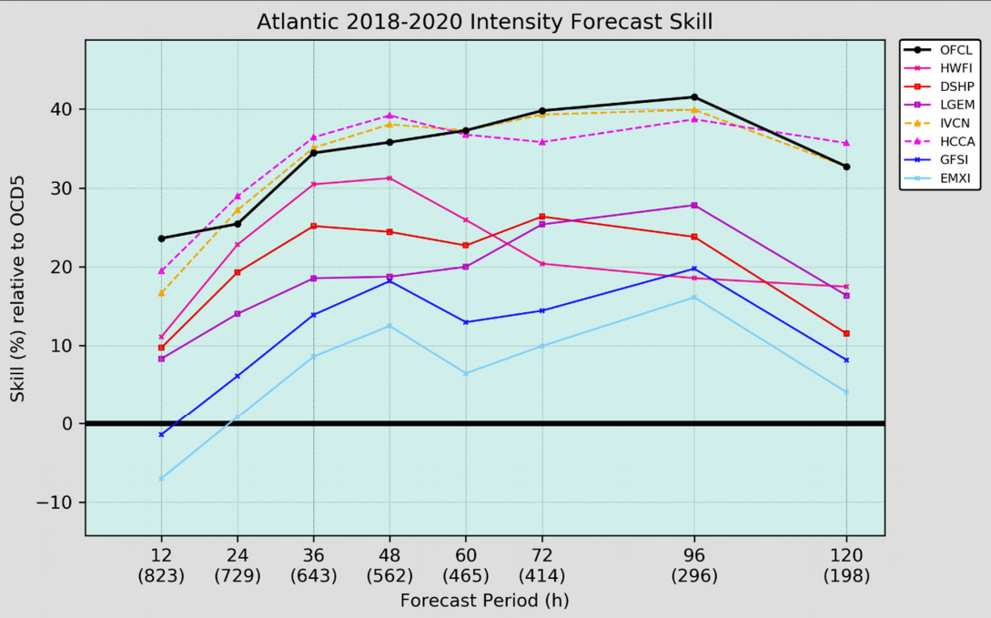
2. American (GFS). GFS output is freely available and probably underpins the forecasts on your weather app. This model underwent its most significant revamp in decades a few years ago, which seems to be bearing fruit for hurricane forecasts. The GFS was the most skillful single model for the 2020 Atlantic hurricane season in the 1- to 3-day range, and its ensembles are particularly improved relative to previous iterations.
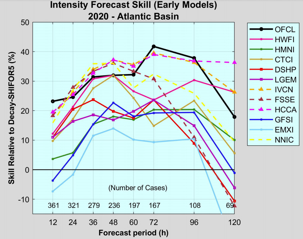
3. HWRF. The flagship hurricane-specific American model is designed to incorporate tropical cyclone inner-core processes. HWRF provides useful guidance, particularly in favorable environments for development, but is biased towards over-strengthening storms.
4. British (UKMET). The UKMET ranks second-lowest in overall global weather pattern forecast errors. For tropical weather, it is an independent second opinion that can be uniquely correct, as with Hurricane Michael, but often has a westward bias for storm motion.
5. HMON. HMON is a refurbishing of an earlier American hurricane model that was state-of-the-art in the early 2000s. HMON actually was a little better than HWRF for track forecasting in 2020 but did much worse on intensity. Often on its own with wacky predictions.
6. Canadian (CMC). The Canadian model performs respectably in the mid-latitudes. A 2019 upgrade improved its tropical performance from laughably bad to merely ignorable. Particularly unreliable within three days relative to other guidance.
7. Navy (NAVGEM). Is it 1999? If not, don’t look at NAVGEM. If it is 1999, your time would still be better spent exchanging Peanut the Royal Blue Elephant Beanie Babies you brought from the future for mint condition Nintendo 64 cartridges.
8. American Mesoscale (NAM). Meant to predict thunderstorm coverage over land, the NAM is not a tropical model. Strengthens depressions into hurricanes and hurricanes into the black hole at the center of the Milky Way. Ignore.
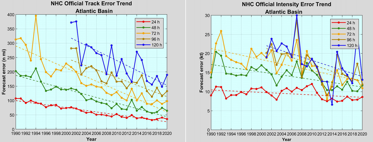
The champion of this demolition derby? The official National Hurricane Center forecast. NHC experts synthesize computer guidance with real-world observations and scientific knowledge to make superior predictions. NHC forecast skill in both 2018-2020 and 2020 alone led all individual models and met or exceeded the best multi-model blends at all lead times. Forecast errors also continue to decline: the average NHC five-day track forecast in 2020 was roughly as accurate as their two-day forecast in 1990.
Overall, while invaluable to specialists, for the public, uninterpreted computer model hurricane forecasts don’t add much value and can certainly cause unnecessary storms and stress. After all, why have raw hamburger when you can eat a steak prepared by master chefs? Keep that in mind in the hurricane season ahead, and keep watching the skies.
Next update: Our regular daily briefing will resume tomorrow for paid subscribers.


Love this article, so helpful in understanding all the models. I think it's one of the best you have written this HS. Thanks for broadening my knowledge