Louisiana Rain: WeatherTiger's Hurricane Watch for September 14th
Tropical Storm Nicholas is depositing heavy rain across the Northwest Gulf Coast.
WeatherTiger’s Hurricane Watch has been selected to share the front page of Substack.com with Salman Rushdie this week, and we’re welcoming our new subscribers by making all daily blog posts free through the 17th.
We hope you enjoy our coverage of a busy week in the Atlantic. If you find it valuable, please consider upgrading to a paid subscription to continue receiving our daily reports, comment and ask questions, and get lots of subscriber extras. As always, thanks for reading the Watch.
Two-sentence Florida tropical threat synopsis: There are no short- or medium-term tropical risks to Florida, other than enhanced rain chances in the Panhandle between tomorrow and Friday due to the eastern fringes of Nicholas. It remains worth keeping an eye on a tropical wave in the far eastern Atlantic, but concerns remain minimal as any risk would be over 10 days out.
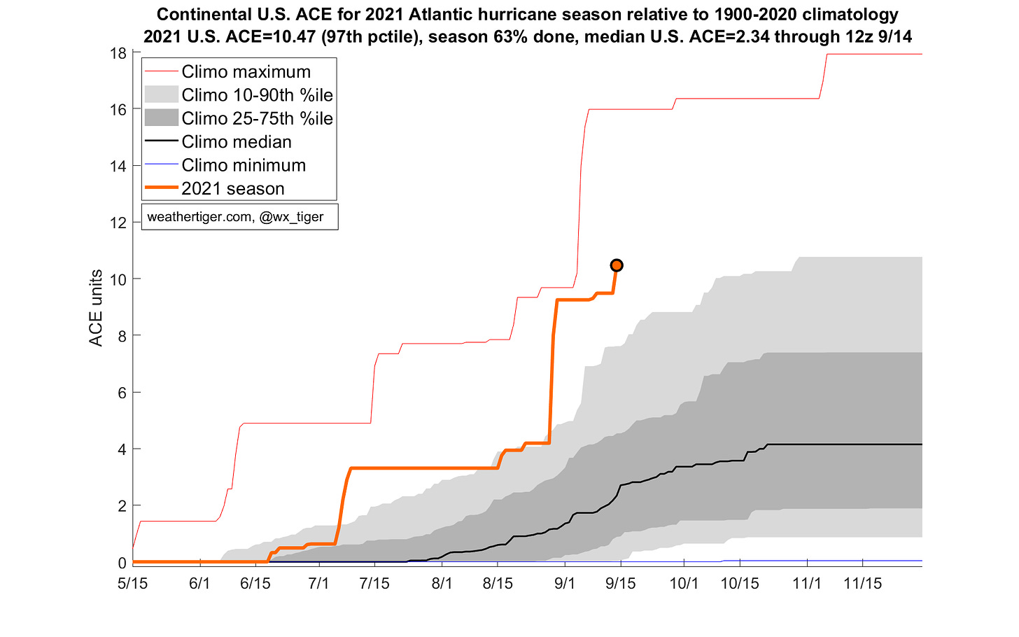
Almanac: It’s Tuesday, September 14th… day 105 of the 2021 hurricane season, 78 days to go. By storm energy, the season is 53.2% complete as a whole, 63.0% complete for the continental U.S., and 54.4% complete for Florida.
Nicholas is the eighth tropical storm or hurricane to make landfall in the continental U.S. in 2021, which has further boosted U.S. ACE tallies to more active than 29 out of 30 years through September 14th. Even if no more storms strike the U.S. this year (hah), 2021 would finish as more active than 90% of hurricane seasons for U.S. impacts.
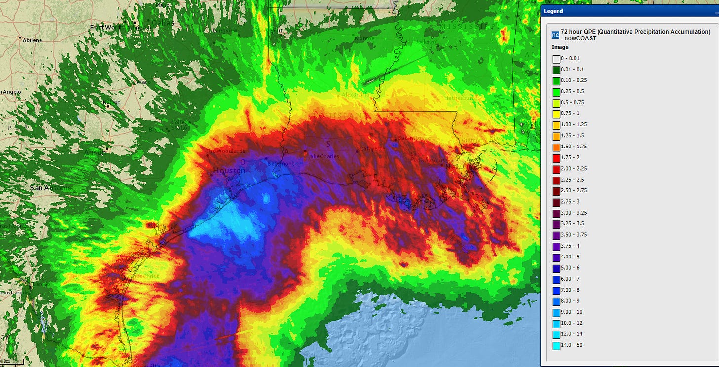
Active Storms: Tropical Storm Nicholas made landfall overnight between Houston and Galveston, briefly peaking as a minimal Category 1 hurricane as it did so. As of 5 p.m. ET, it remains a minimal tropical storm centered near Houston, with almost all rain east of the center. As expected, the primary impact of Nicholas has been flooding rainfall across coastal eastern Texas and southern Louisiana, where 3-day rainfall totals (above) are already over 10” in some places and 4-8” for many.
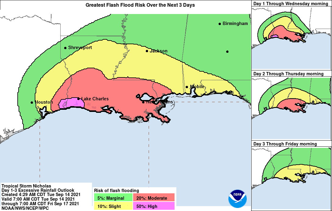
Nicholas will move only slowly east over the next two to three days, and another 4-8” of rain is certainly possible in Louisiana. Flash flooding is ongoing in far eastern Texas, and those risks will continue through at least Thursday. As Nicholas spins down and slides east, widespread rain chances will also overtake the Florida Panhandle between tomorrow and Friday, tallying 1.5-3” of rain through the weekend.
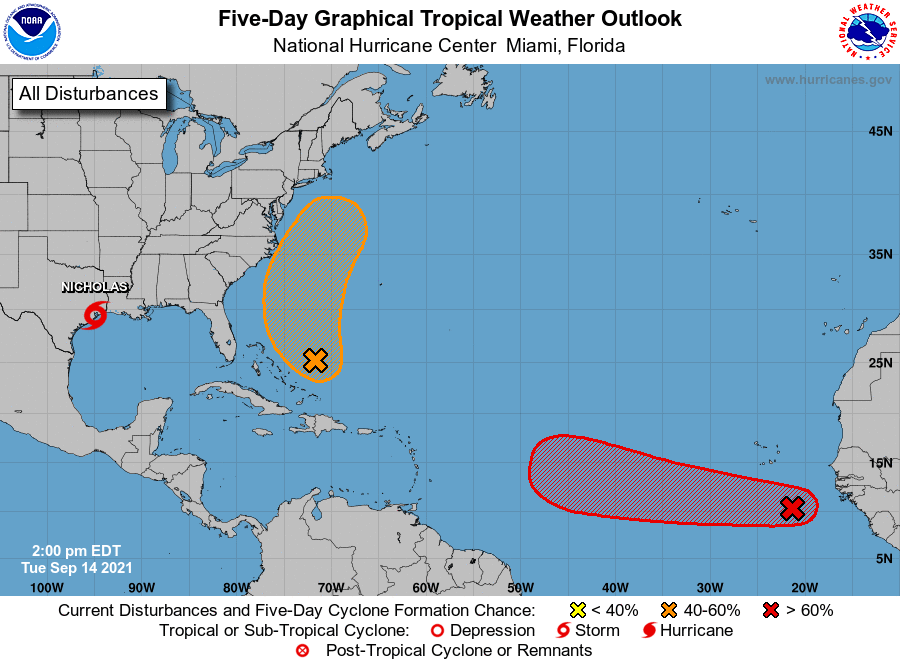
Current disturbances in NHC outlook, with 2-/5-day NHC development odds:
Invest 95L in the Eastern Atlantic (70/90%): A tropical wave in the far eastern Atlantic today has a well-defined mid-level circulation as it passes south of the Cape Verde islands. Convection is lacking today, but Invest 95L has a very good chance of slow development over the next 3 to 4 days as it moves steadily westward across the Main Development Region.
However, models are overall less enthusiastic about Invest 95L’s prospects early next week, as the disturbance is likely to encounter an unfavorable shear axis that would probably weaken anything approaching the Lesser Antilles. If 95L is on the stronger end of its potential, it may well turn north into the open Atlantic in about a week; if it is already on the weaker end, the shear could dissipate it.
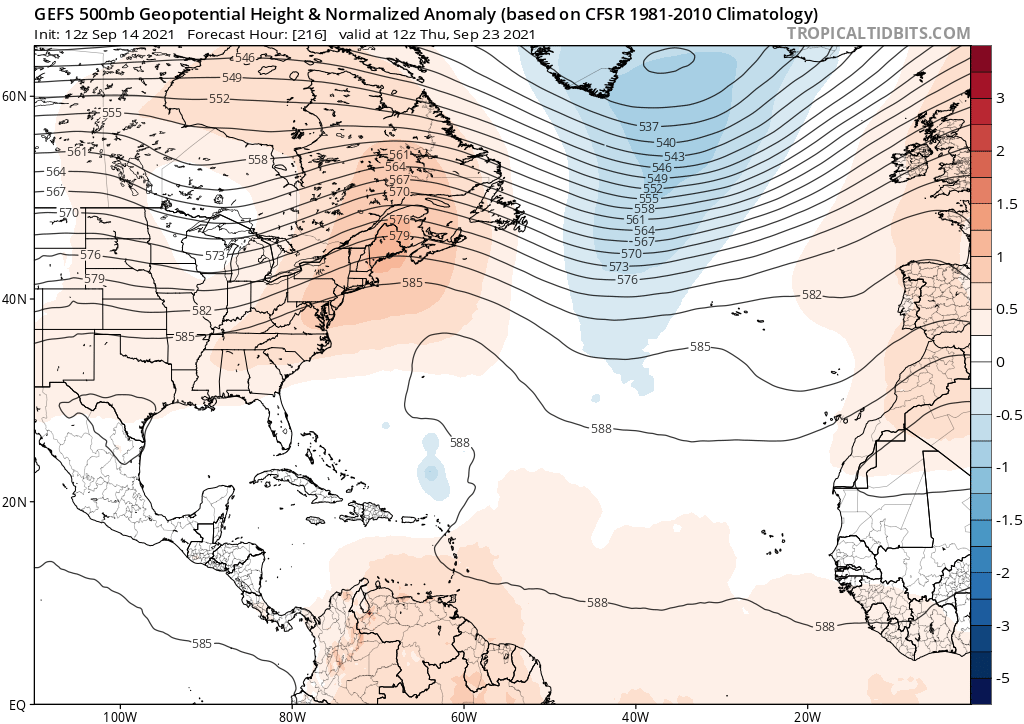
There may remain a middle ground in which 95L is weakened by the shear but survives and turns back west under the guidance of East Coast ridging (see above) beyond a week from now. That scenario would be of concern for the eastern U.S., but the window of that possibility between the other outcomes is quite narrow. We’ll keep watching, but there is no cause for concern.
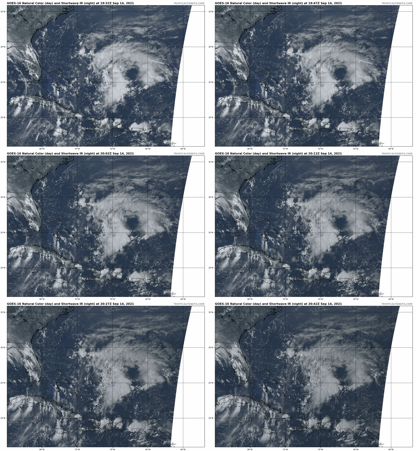
Invest 96L in the Southwestern Atlantic (40/60%): A disturbance northeast of the Bahamas is generating a good deal of convection today, will likely become better organized in two or three days as it turns north and passes east of the Carolinas. Look for the possibility of enhanced rain chances along the upper Southeast Coast later this week, especially the Outer Banks, though 96L will likely remain offshore and lopsided with rain favoring the eastern half of the disturbance. This system will turn northeast to the east of the mid-Atlantic over the weekend, and is no threat to Florida.
Elsewhere: No other active disturbances or significant future threats.
Next report: Next report tomorrow afternoon. Until then, keep watching the skies.


