Into the Unknown: WeatherTiger's Weekly Column for July 1st
Tropical Storm Elsa is raising hackles and triggering an avalanche of Frozen puns.
Welcome to WeatherTiger’s Hurricane Watch! On Thursday afternoons through October, we’ll be releasing a long-form column digging deeper on current conditions, or some other aspect of tropical meteorology, forecasting, or history if the Atlantic is quiet. Paid subscribers will receive these columns and be able to comment and ask questions, as well as get all of our daily forecast briefings, in-depth forecasts and video discussions during Florida hurricane threats, live landfall coverage, and expanded seasonal outlooks. Free subscribers subscribers will also receive this weekly forecast column and selected storm coverage. Sign up below to get WeatherTiger’s Hurricane Watch newsletters all season long.

The storms rage on as the 2021 hurricane season’s big summer blowout rolls into July, with Tropical Storm Elsa testing the limits and breaking through 2020’s records for early season activity. And though we would all rather be relaxing in the summer sun just letting off steam, Florida and the Gulf Coast will need to carefully monitor the forecast this holiday weekend.
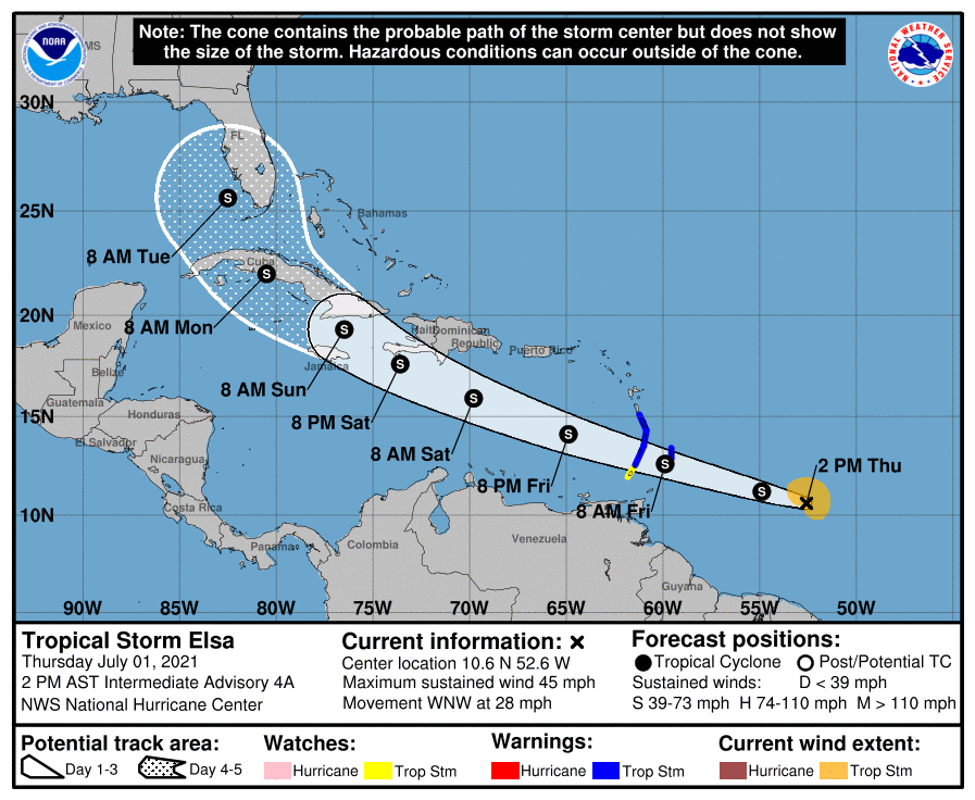
As of Thursday afternoon, the National Hurricane Center places Tropical Storm Elsa around 500 miles east of the Windward Islands, with maximum sustained winds around 45 mph. Elsa is racing west-northwest at over 25 mph, which is much quicker than usual forward motion for a storm located in the Atlantic’s Main Development Region between the Lesser Antilles and West Africa.
On this track, Elsa will race through the southern Windward Islands overnight into Friday, and pass several hundred miles south of Puerto Rico early Saturday morning, likely as a mid-range tropical storm. Forecast confidence decreases beyond that point, with possibilities for next week ranging from a hurricane in the eastern Gulf to dissipation over the Greater Antilles remaining on the table.
Before digging into the forecast, an aside: yes, Elsa shares a name with the ice queen from Frozen, and yes, her sister Anna was also on the 2021 name list, and yes, as the dad of a two- and four-year-old, someone did this on purpose. Other meteorologists will make Frozen puns, but only I will make all the Frozen puns. Not better ones, just more. Your tolerance for this is likely correlated to the frequency with which Elsa stickers are lovingly applied to your face while you listen to “Let It Go” on repeat.
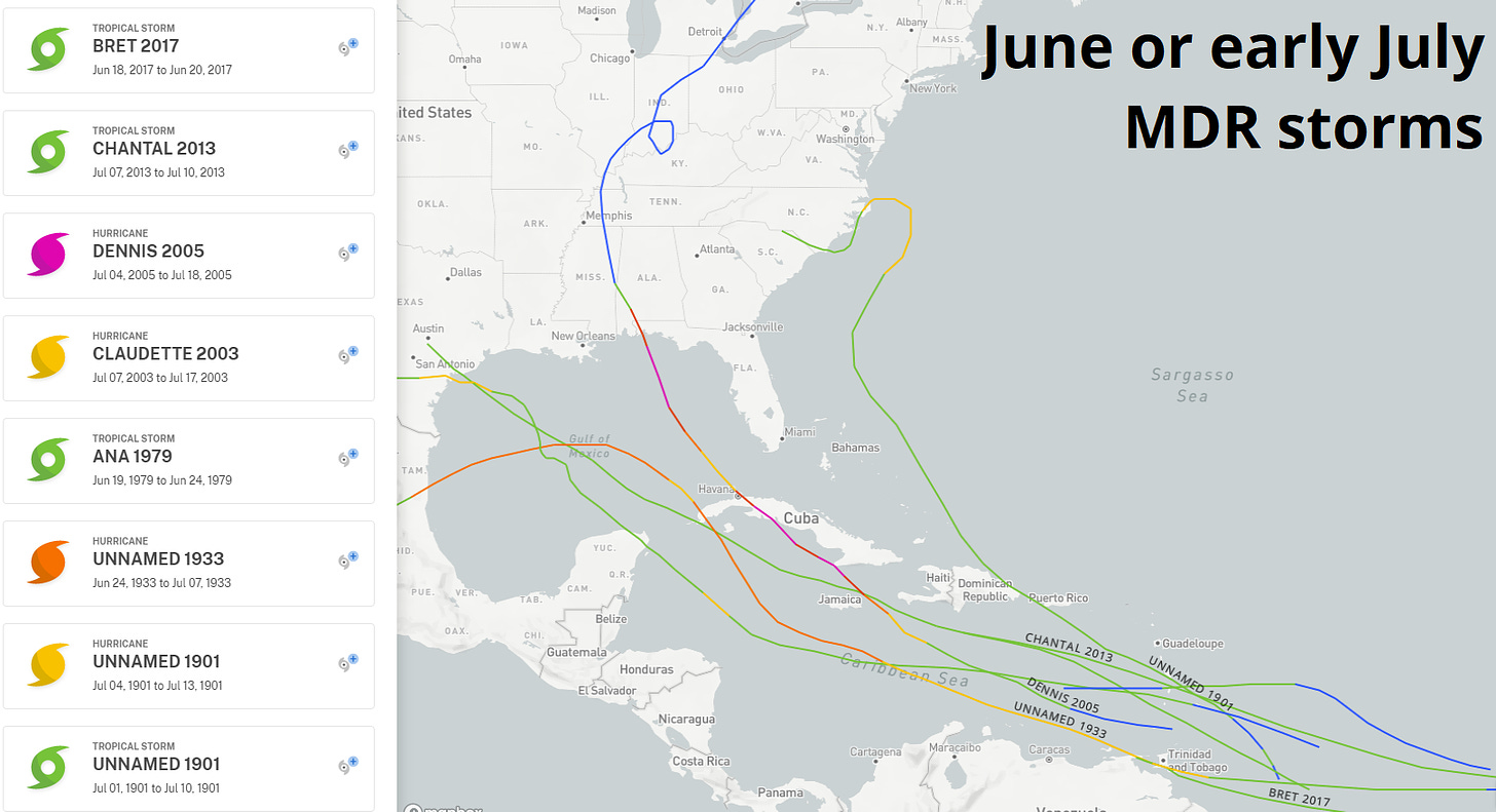
Climatologically, Elsa’s development is a step into the unknown on several fronts. For the first time in forever, the fifth named storm of the Atlantic hurricane season formed on or before July 1st, breaking a record set last year by Tropical Storm Edouard on July 6th. Moreover, tropical development in the Main Development Region is rare prior to mid-July, with only nine storms since 1851 matching Elsa’s general track through the southern or central Windwards.
This set of historical cases informs the possibilities for Elsa. Four of these storms, including Chantal in 2013 and Bret in 2017, eventually dissipated in the Caribbean. Another four, including Claudette in 2003 and Dennis in 2005, later entered the Gulf of Mexico; the final storm moved east of Florida.
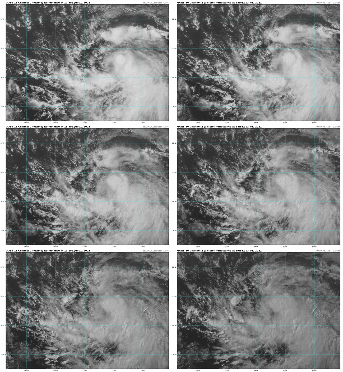
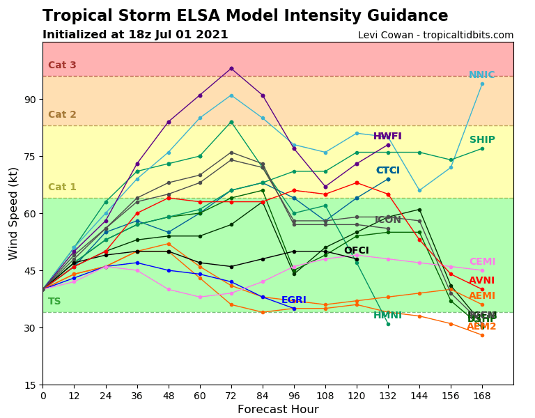
Structurally, Elsa is a bit of a fixer-upper, with its low-level circulation showing itself to the north and west of most of its deep convection on Thursday. Elsa’s fast movement, steered by strong high pressure to its north, is causing this displacement and holding it back from quick intensification. By late Friday, steering currents may become a little less rapid as upper-level shear slackens, offering an early weekend window for strengthening over the Caribbean as indicated by some hurricane-specific model guidance.
The next question is whether Elsa will interact with Hispaniola, Jamaica, or western Cuba later over the weekend in a way that significantly weakens or dissipates the storm. History, and the European model, suggest this possibility. However, today’s faster and more westward motion increases the chance that Elsa conceals itself a little farther south, and either does not feel the impact of the high mountains of the Greater Antilles, or passes over the less disruptive, lower terrain in western and central Cuba. As shown below, successive runs of the skillful GFS Ensembles have been correcting further south and west for the last couple of days, supporting this observed trend.
If that occurs, there would be more of an open door for an organized system to enter the southern or eastern Gulf early next week, when East Coast troughing will likely turn Elsa more to the north or northwest. The sea surface temperatures in the western Caribbean and eastern Gulf are in the mid 80s, which is plenty warm enough to support a hurricane, should the other pieces fall in place. (Though the cooler SSTs in the eastern Atlantic never bothered Elsa, anyway). It is far too early to suggest any specific track or impact on the Gulf or the Southeast Coast, but the possibility of a storm threat is credible and Elsa should be watched this weekend. The timing of any adverse weather conditions, such as the wind howling like a swirling storm inside, would be in the late Monday to Wednesday range for Florida.
Overall, the forecast for Elsa remains uncertain. It could plausibly wind up in the pile of forgotten early season Caribbean flameouts, or be an unusual July threat to the Florida or Gulf Coast. Some things never change, though: WeatherTiger will be with you all the way through Elsa. Keep watching, and be one with, the wind and skies.


