Full-on Rainstorms: The Hurricane Watch for November 16th
Southeast Florida catches significant rain and wind from a frontal low as Tropical Storm Watches go up for portions of the Greater Antilles due to Potential Tropical Cyclone 22.
Florida tropical threat synopsis: No tropical threats to Florida over the next 7-10 days.
Almanac: It’s Thursday, November 16th… day 168 of the 2023 hurricane season, 15 days to go. By total storm energy, the season is 96.9%, 99.4%, and 99.0% complete for the Atlantic, continental U.S., and Florida, respectively.
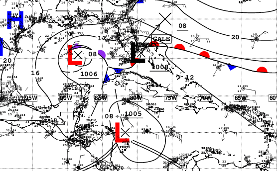
While tropical landfall activity is largely behind us in the continental U.S. by the second half of November, impactful weather is by no means limited to tropical storms or hurricanes. Last night, a frontal low swept through the Florida Keys and Southeast Florida, bringing with it impacts roughly equivalent of a moderate/strong tropical storm landfall. Wind gusts across coastal Palm Beach and eastern Broward and Miami-Dade Counties were generally 50 mph or higher, with offshore stations peaking at up to 75 mph! This coupled with rainfall totals of 6-12” led to downed branches, flooded streets, and power outages for over 100,000 customers. Because this low pressure system is connected to several fronts, it is not a tropical cyclone, but this matters little for impacts. With an active subtropical jet likely due to a strong El Nino, this is likely not the last non-tropical Gulf low to have significant impacts on Florida this winter.
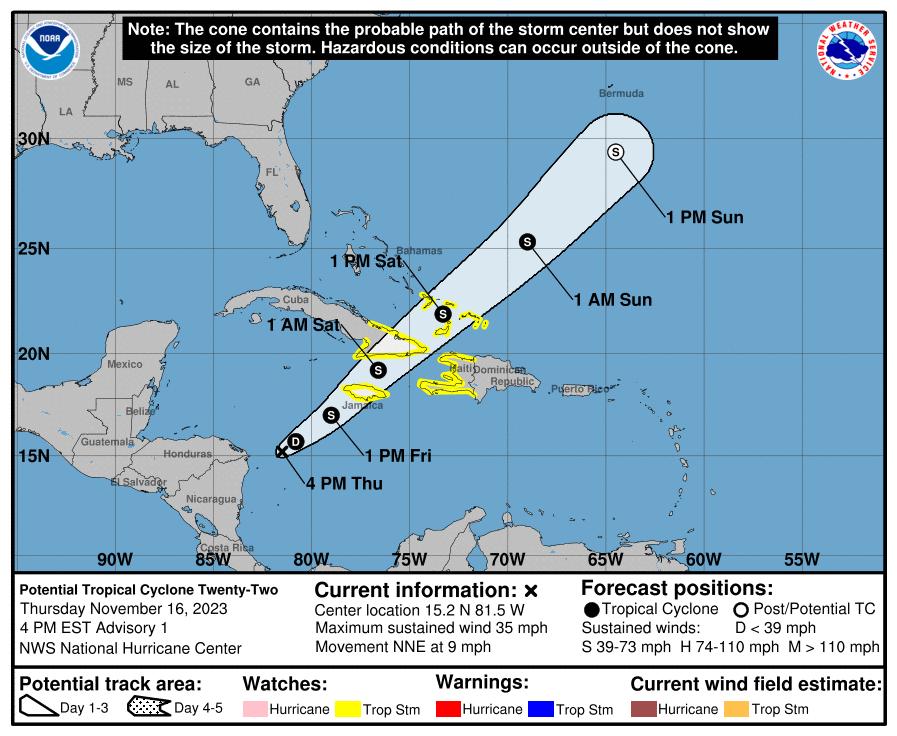
Active storms: While Florida’s active weather is being driven by the mid-latitude jet, there is also a proto-tropical storm lurking in the Caribbean. The NHC has begun issuing advisories this afternoon on Potential Tropical Cyclone 22, which has a 70% chance of becoming a tropical depression or Tropical Storm Vince in the next two days. Tropical Storm Watches are in effect for the eastern quarter of Cuba, Jamaica, Haiti, and the Turks & Caicos islands, as PTC 22 is likely to reach low-end tropical storm status before losing tropical characteristics over the weekend.
The good news remains that PTC22/Vince will have no impact on the continental U.S., as the front moving east from Florida hustles the system due northeast over the next three days. Expect heavy rain and some gusty winds in the central Greater Antilles through Saturday as this system speeds northeast, with general totals from eastern Cuba to Hispaniola on the order of 4-6”, locally higher due to terrain.
Disturbances in the NHC tropical weather outlook: None.
Elsewhere: No other disturbances in the Gulf, Caribbean, or Atlantic, and none are likely to develop in the next 7 days.
Next update: The final regularly scheduled tropical bulletin of the 2023 hurricane season will be out next Monday.


![[Image of rainfall potential from the Weather Prediction Center] [Image of rainfall potential from the Weather Prediction Center]](https://substackcdn.com/image/fetch/w_1456,c_limit,f_auto,q_auto:good,fl_lossy/https%3A%2F%2Fsubstack-post-media.s3.amazonaws.com%2Fpublic%2Fimages%2F8f56bab0-9d02-4b10-8316-03858efd055e_2292x1795.gif)
I forgot to mention, I’m only about four miles inland from the ocean. And how I know the feeder got moved...I have a camera secured to it for a citizen science project that I do, and I could tell when I looked at videos this morning it had moved. 😉
Here in Stuart, we actually had a recorded gust of 53 mph. I can’t believe the NWS is only showing more or less 30 mph gusts. They were *far* more than that; it was at least true mid tropical storm force winds! There were 56 mph gusts (42 steady) at 11:47 pm, and 64 mph gusts (55 steady) at 3:56 am recorded at the Hobe Sound National Wildlife Refuge weather station. Winds were so strong, they broke off the top of a dying pine tree in the wetlands behind me, and even forced a caged platform bird feeder on a pole in my yard to go slightly off kilter.
I went out at about 11:00 last night with my anemometer (manual, handheld), in the front of my house, and while it was so gusty it nearly knocked me over, I only got 25-30 mph gusts at full force. (Too many obstacles/not high enough to record the *real* butt kickers 🫤). But gusts were very similar to when rain bands from an oncoming/passing hurricane come through.