Four Strong Winds: The WeatherTiger Newsletter for January 2024
2024 picks up where 2023 left off, with another round of lashing wind and severe weather for Florida and the Southeast U.S.
Welcome to WeatherTiger’s monthly off-season newsletter! Until hurricane season picks up again, I’ll use this space to keep you informed on key developments in the weather world. As always, thanks for subscribing, and expect the next newsletter in the first week of February.
El Nino winters are often characterized by an active, energetic pattern in the U.S. southern tier, with above normal risks of severe weather in Florida and the Southeast U.S., and the 2023-24 El Nino seems primed to challenge the 1997-98 Nino as the poster child for that tendency. Yet again, a powerful low and associated cold front will bring potentially damaging winds, coastal flooding, the chance of tornadoes, and heavy rainfall to Florida, with impacts beginning tonight in the Panhandle and continuing through Tuesday (1/9).
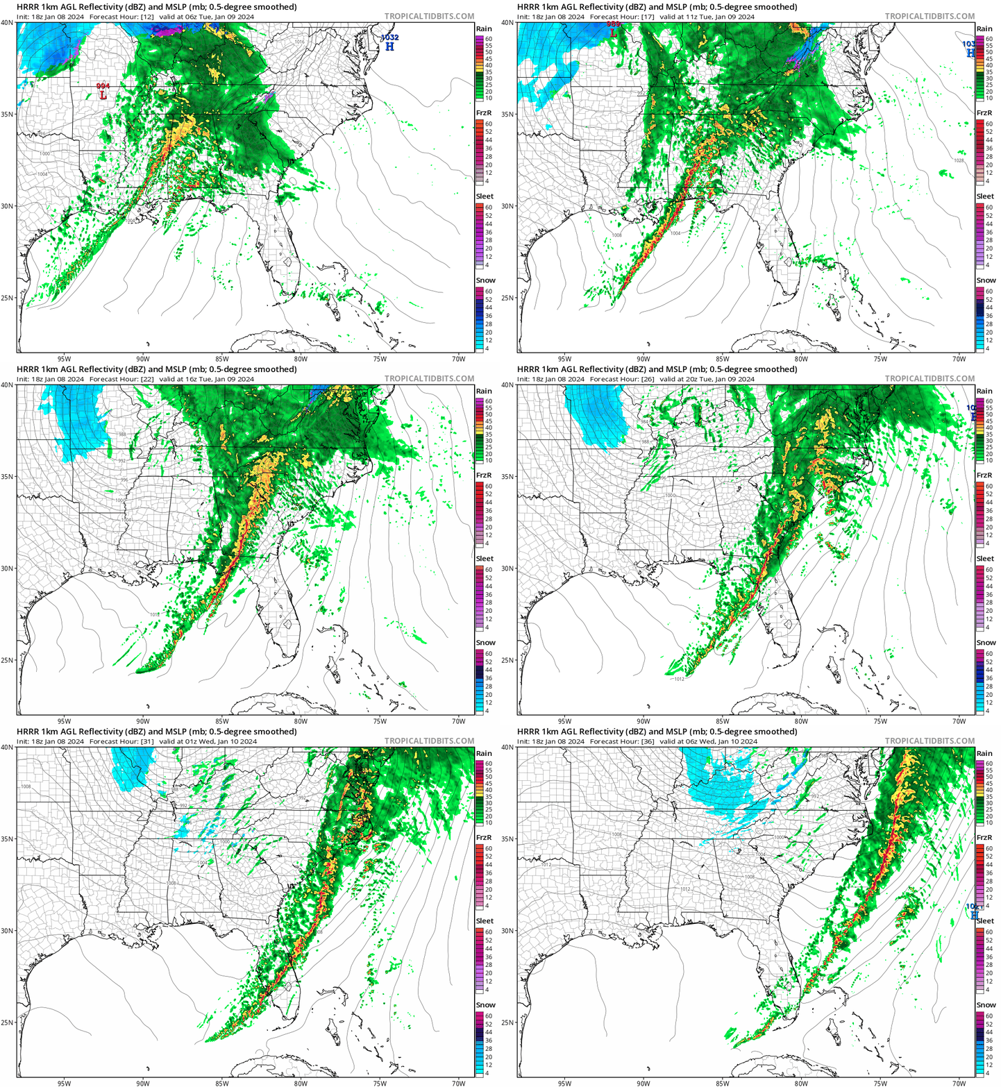
The key feature setting this system apart from garden-variety winter fronts is a roaring low-level jet streak driven by an extremely strong low riding up the Mississippi Valley. As shown above, winds about 1 mile up in the atmosphere tomorrow will be screaming at anywhere from 70 to 90 mph in the core of this streak, which will roll across North Florida and the Deep South and eventually reach the Northeast on Wednesday, while coming in a little weaker in peninsular Florida.
As a line of thunderstorms moves east tonight and tomorrow, some of those powerful winds aloft will reach down to ground level, in diminished but still potent form. There is also a severe weather threat ahead of the main line, especially in western Florida. Let’s look at the key hazards one-by-one:
Wind
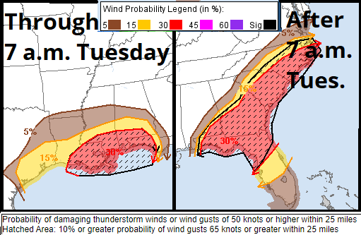
Widespread damaging wind is the top threat from this system. With the low-level jet roaring, even a little instability will bring those winds down to the surface as gusts. While instability will be at a premium tomorrow, particularly further east, essentially all of the Deep South, North Florida and Carolinas will likely see 45-60 mph wind gusts beginning early Tuesday and ending behind the squall. (In Tallahassee, the squall line will pass through around 10-11 a.m. plus or minus a few hours.) Look for 60-70 mph wind gusts along the northern Gulf Coast and 60-80+ mph gusts inland in severe cells or the most intense portions of the squall line. Wind gusts over Central and South Florida will be more like 30-45 mph Tuesday afternoon and evening.
These winds will cause tree damage and scattered power outages in North Florida and the Deep South. Be in a safe place and off the road when the line of storms hits, and take in any loose items from your yard tonight. That includes trash cans, unless you want to spend the second half of your day tomorrow picking up garbage.
Coastal Flooding
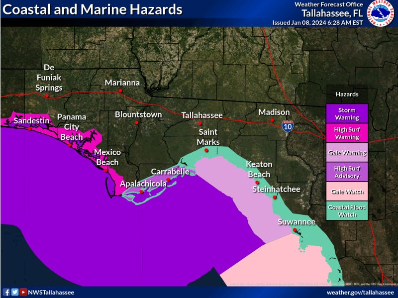
With southerly winds piling water into the northeast Gulf, this system will produce another round of coastal flooding in Apalachee Bay and the Big Bend. A Coastal Flood Warning is in effect for Apalachicola east to Cedar Key, where the highest winds will coincide with early afternoon high tide. Look for 3-5’ of surge in these areas, and 1-3’ further west and south along the Florida Gulf Coast.
Tornado Risks
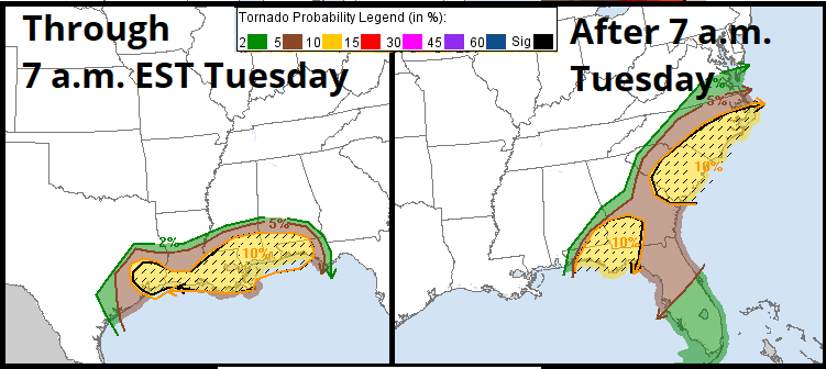
The tornado threat with this event is concentrated along the northern Gulf Coast, where there may be enough instability to generate some overnight supercells before the squall line develops. The greatest risks are from far eastern Texas to far western Florida. There is also a risk of fast-developing, short-lived, and unpredictable tornadoes within the squall, especially in the Panhandle tomorrow morning, so keep a way of receiving Tornado Warnings handy, and be ready to retreat to an interior room. There is some chance of tornadoes farther south and east as well, though risks decline in that direction.
Heavy Rainfall
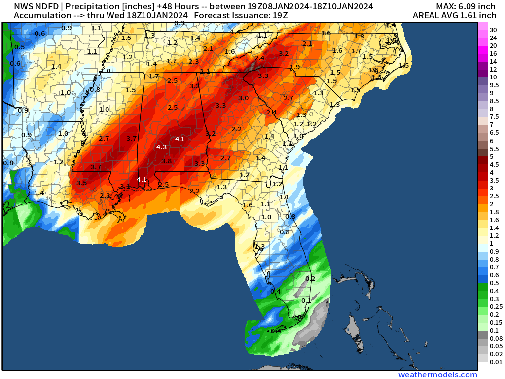
Finally, there is the chance of localized flash flooding with these storms, especially given recent copious rainfall. These risks are most acute from the northern Gulf Coast northeast into the Carolinas, where 2-4” of rain is expected. Totals in Florida will likely be 1-2” in the Panhandle and less than 1” in the peninsula, where flood risks are lower. Still something to be aware of: turn around, don’t drown, or better yet, stay off the roads tomorrow morning and during the squall line.
There are a lot of moving pieces here, so keep an eye on the latest from your local National Weather Service office and the Storm Prediction Center. And finally, for the first but probably not last time in 2024: Stay safe, Florida.
The ENSO whisperer
Ok, El Nino, we get it. You’re a strong El Nino, and no one can say otherwise. Now please stop cancelling school.
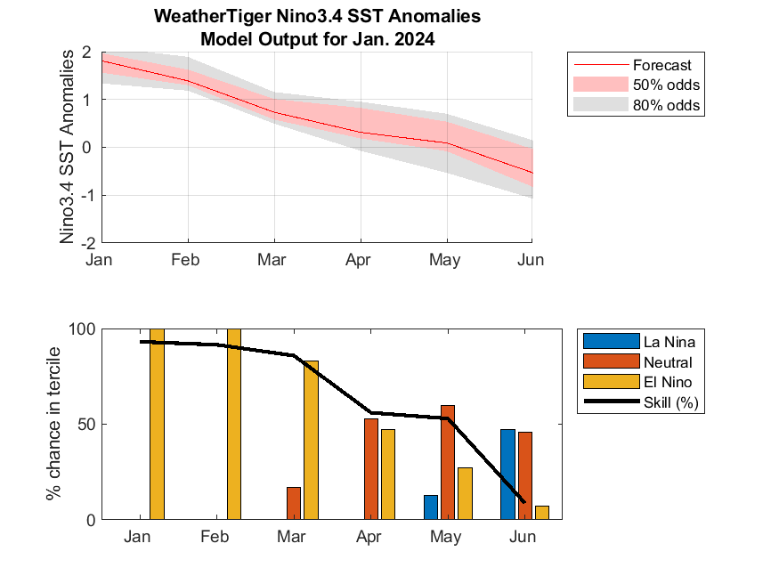
However, that may not be true for all that much longer, as an impressive model consensus is developing for a rapid weakening of El Nino heading into spring and summer, as shown in WeatherTiger’s in-house modeling (below) and elsewhere:
While ENSO forecast skill beyond the so-called spring predictability barrier is low, this is the first run of our model showing a slightly greater chance of La Nina conditions than not by June. I’ve noted that while our model itself is quite skillful, its trend is also a meaningful predictor. I’d bet on a La Nina by mid-summer at this point.
2024 hurricane season update
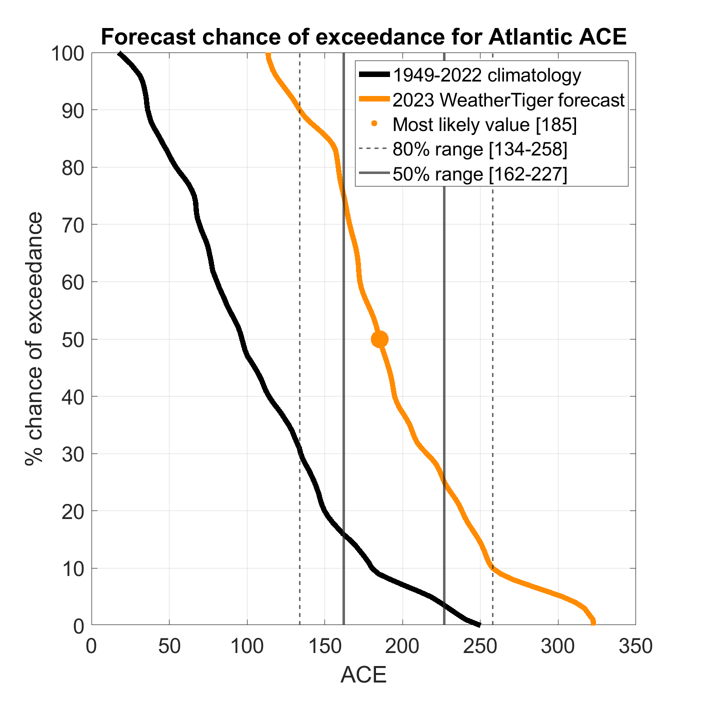
And that, in turn, plays into increasingly bullish expectations for hurricane season 2024. While my predictive methodology this month is less rigorous than my more formal seasonal outlooks, I did take a look at version of WeatherTiger’s seasonal ACE model, using the state of the ocean and atmosphere in November and December to project updated outcome odds for the 2024 season. The exceedance curve is below:
And that exceedance curve is a nasty one. Overall, this forecast now has about an 80% chance (!) of 2024 ACE landing in the top third of seasons since 1950, up from 55% last month. The most likely outcome of around 180 ACE has jumped by about 50 ACE units since last month, against a 50-year normal ACE around 100. While I still wouldn’t read too much into these forecasts until April, it is clear that the expectation of an incredible disappearing El Nino coupled with warm Atlantic SSTs are already showing up as heightened background odds of a busy hurricane season.
Whew. Eight days into 2024, and it’s already getting on my last nerve. The good news for winter lovers is that I don’t see another significant severe event on the horizon for Florida, and temperatures will turn notably colder starting around the 15th. The long range forecast for February also looks a little cooler than average, possibly with a boost from fluctuations in the strength the stratospheric polar vortex; I’ll get into the nuts and bolts of that in the next newsletter. Unless of course, I have to cover another widespread Florida severe weather event, which, you know, is 50/50 at this point.



Your ACE 2024 forecast is breathtaking!