Florida Winter Storm Forecast Update for January 21
A historic and impactful winter storm is coming tomorrow to the Florida Panhandle
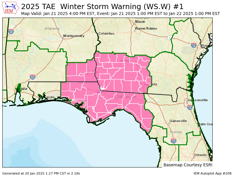
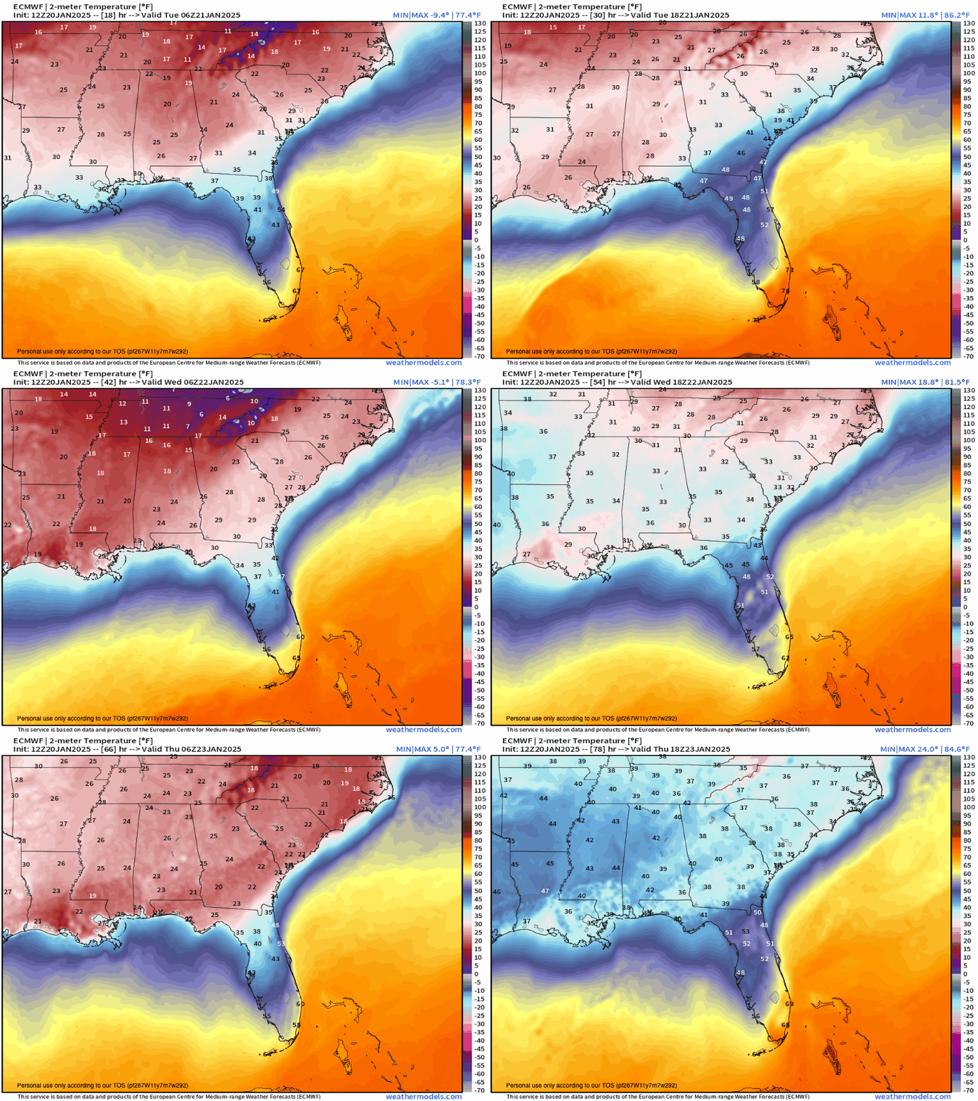
North Florida is little more than 24 hours away from the start of what has the potential to be one of the most impactful winter storms in Gulf Coast history. And while uncertainty about precipitation type in the eastern Panhandle is likely to go right down to the wire, colder trends aloft are tilting the odds away from rain, and towards a messy mix of ice, sleet, and snow Tuesday night into Wednesday morning. Winter Storm Warnings, the first in seven years for Florida, are in effect from Pensacola east to Gainesville and Jacksonville, including Tallahassee.
Looking at the meteorological set-up, the seven keys I discussed on Thursday needed to square the circle of Florida snow are turning at the same time. Over the last few days, the uncertainty regarding the presence of these ingredients—Arctic airmass, triggering trough, and storm track--- has decreased. Because of that, both global and regional weather models have converged on a scenario with few precedents in Florida weather history, one in which an impressive amount of precipitation falls mostly in frozen form from eastern Texas to Florida’s Big Bend.
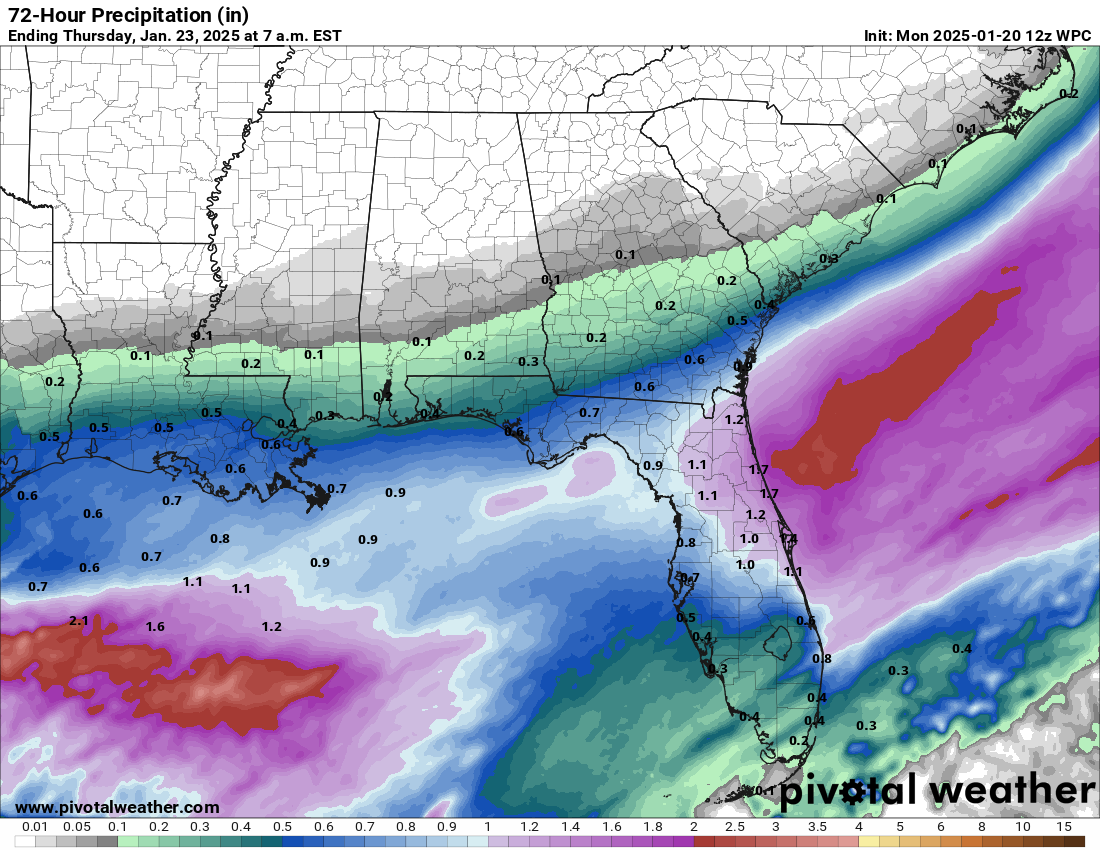
There are two major uncertainties to discuss for Florida. The first is precipitation amount. Model ensembles have trended higher over the last few days and are now in good agreement that the Panhandle will see anywhere from 0.25” to 1” of liquid-equivalent precipitation (that means if you melted down snow or ice), heaviest towards Jacksonville and lighter towards Pensacola. Tallahassee sits on a sharp gradient in expected totals, with around 0.5” most probable, but some models showing closer to 1”.
That amount of precipitation falling as all or mostly snow or ice in North Florida is borderline unprecedented. For instance, in the December 1989 snowstorm, Tallahassee and Jacksonville saw 1” and 2.5” of snow from 0.1” and 0.35” of liquid equivalent, respectively. No matter where we fall in the forecast range, we’re really working with a lot of moisture for how cold it will be, which means a lot of potential for mischief.
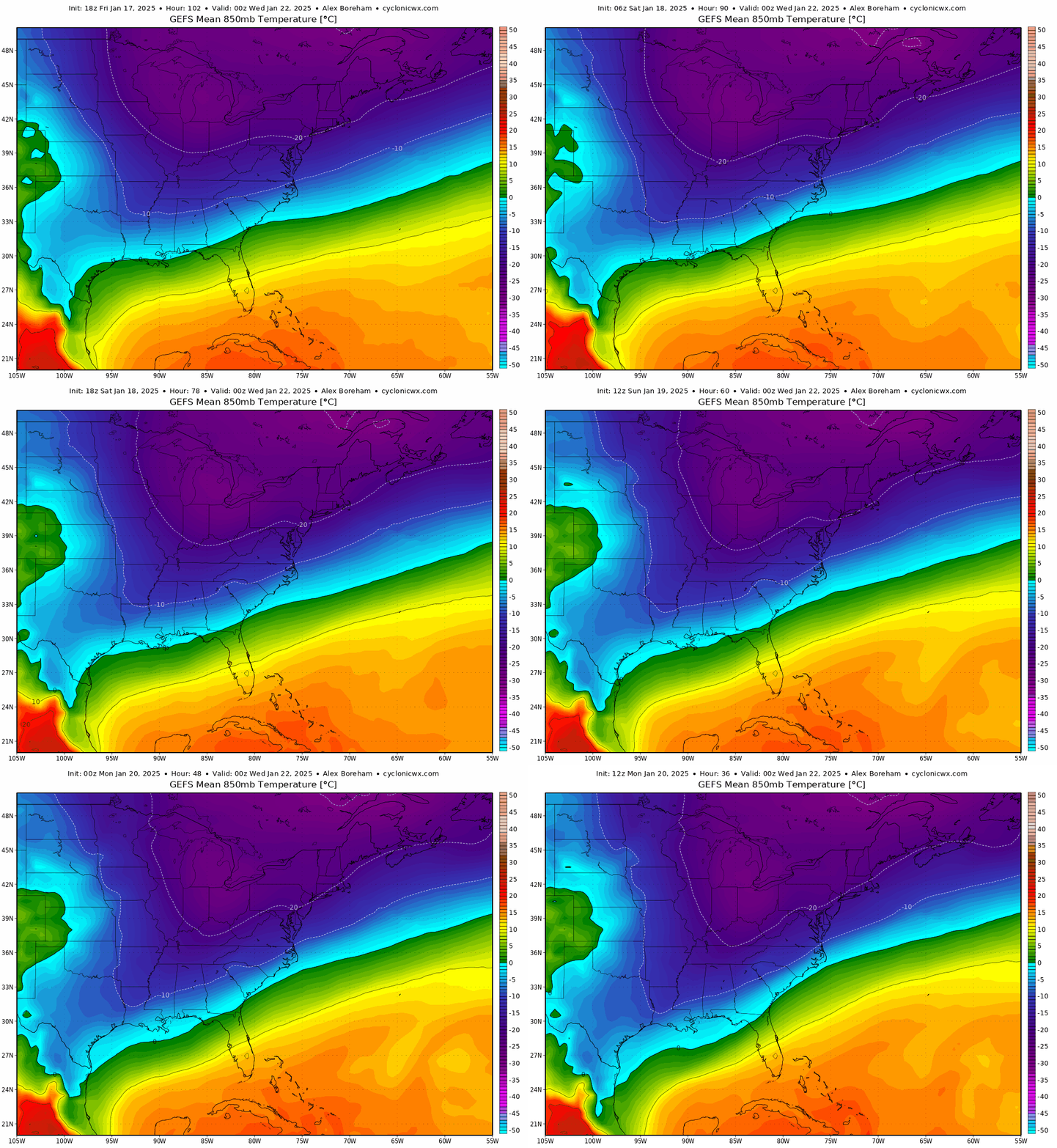
The main uncertainty, as always, is precipitation type, which is notoriously difficult to forecast until a winter storm is underway. The reason for that is because a powerful storm like this one turns the atmosphere into a complex layer cake of above and below freezing levels, into which snowflakes aloft fall, melt, and then potentially refreeze. Freezing rain occurs when a relatively thin layer at the surface is below freezing, while ice pellets occur when the surface cold layer below a so-called “warm nose” about a mile up in the air is thicker. Snow needs temperatures near or below freezing at all levels of the atmosphere.
This is going to be an historic storm any way you slice the cake, but the worst impacts will be if the majority of precipitation falls as a freezing rain that ices over roads, powerlines, and trees that have been repeatedly pulled this way and that in the past decade by hurricanes, tornadoes, and severe thunderstorms. The good news is that ensemble guidance through mid-day Monday has a slight colder trend in temperatures aloft as the event approaches. However, even factoring in this trend, North Florida will be the battleground between multiple precipitation types Tuesday night into Wednesday morning.
Let’s take a look at some rough moisture and precipitation type forecasts by region, keeping in mind: 1) these forecasts are uncertain and can change before go-time and 2) hyper-local variability in how the storm plays out could well be extreme.
Western Panhandle, including Pensacola
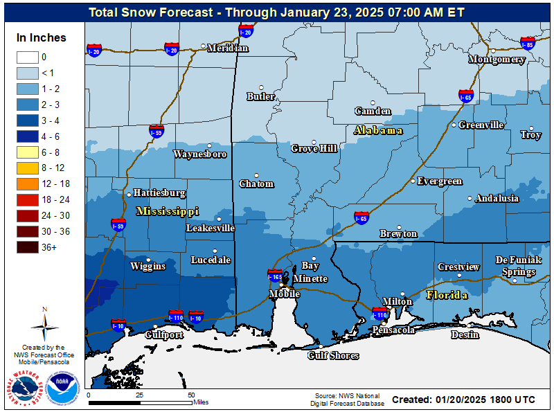
For Pensacola and surrounding areas, the forecast is a little easier to make, because the consensus of data suggests that snow will be the dominant precipitation type west of the Apalachicola River and away from the immediate coast, perhaps starting as a little ice. The expected liquid-equivalent precipitation is lower here, as the western Panhandle exchanges less moisture for a colder airmass both at the surface and aloft.
In general, this region can look for the onset of occasional light mix or snow Tuesday morning, with the heaviest snow moving through Tuesday afternoon and evening. In general, 1-2” total snow accumulations inland are the best bet, though local totals to 3” or even more wouldn’t be surprising. Snow on the beach in the western Panhandle is probable, though accumulations will be lower on the coast. For what it’s worth, Florida’s all-time single-storm snow record is 4”, set in Milton on March 6, 1954. Snow should taper to flurries and end by very early Wednesday morning.
Eastern Panhandle, including Tallahassee
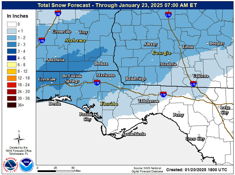
The forecast is the least certain in the Big Bend and eastern Panhandle, the most probable region of overlap between deeper moisture and temperatures one to two miles up in the atmosphere right around freezing during the peak of the storm. The colder trend in the models over the last 24 hours has continued to diminish the odds that the Capitol region sees significant rainfall, at least east to the Suwannee River. Tallahassee, that means we should mostly see some combination of freezing rain, sleet, and snow. A few aesthetic flurries (or mix) are possible Tuesday morning, with the main event starting Tuesday evening and continuing through the overnight hours and tapering before daybreak Wednesday.
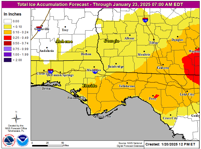
With the freezing line aloft likely cutting right through the Big Bend, I hesitate to put a fine point on the precipitation type and amounts forecast yet. If the precip can manage to stay snow more of the time, the potential for 1-3” snow totals (or more? Am I really typing this???) is there, particularly closer to the Apalachicola River or Florida-Georgia line. Realistically, especially in the eastern Big Bend, some snow is a good possibility at the beginning and end of the storm, but a period of freezing rain or sleet is probable overnight as temps at the surface are below freezing but a warm nose above the surface pokes just above freezing. If that happens, up to 0.25” of glaze or ice pellets is possible. Basically, It’s going to go right down to the wire for precipitation type in the eastern Panhandle, so please manifest and visualize snow. Let’s hope for more Snolepocalypse, less Tallahassleet or icing.
Northeast Florida, including Jacksonville
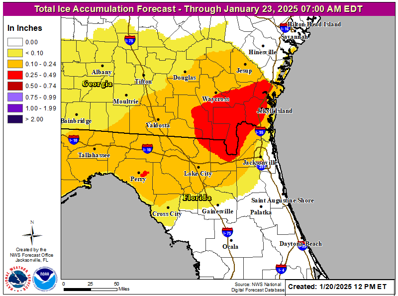
Further south and west towards Gainesville and Jacksonville, liquid-equivalent precip will be in the 0.75” or more ballpark, while temperatures aloft are likely to be above freezing for most of the storm. That means precipitation will probably start out as some rain Tuesday evening, with freezing rain likely to be more prominent in the wintry mix in the back half of the event early overnight into Wednesday, and perhaps some snow as the event concludes by Wednesday late morning. Glaze or ice totals of 0.1-0.25” are probable here, especially further north and west. Don’t expect significant frozen precipitation much south of a line Gainesville to Saint Augustine, though only a fool would be confident in a Gulf Coast precipitation type forecast.
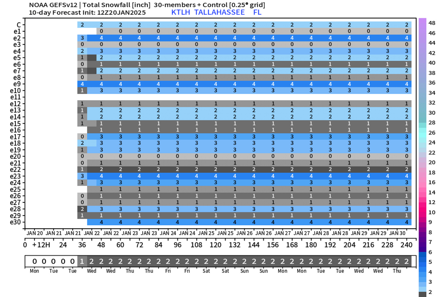
The Dream Is Alive
Finally, some forecast caveats. First, take ALL precipitation type forecasts before the actual storm starts with huge grains of salt, the kind we don’t have the capability to put down on our roads. Big forecast changes in terms of who gets what are absolutely possible. Writing this column as a snow lover feels like I’m writing weather fanfic, but this forecast is simply my best and hopefully unbiased guess on the general outcome the winter storm as of mid-day Monday. I could well be wrong. Please refer to the National Weather Service forecast offices in Mobile, Tallahassee, and Jacksonville for the latest information.
Overall, though all signs a day out are that a historic winter storm is on its way to the Panhandle. Temperatures in the 30s through the day Wednesday and returning to the 20s Wednesday night mean prolonged hazardous travel conditions, including hard-to-see black ice, will begin from west to east on Tuesday and may persist into Thursday morning. Let’s stay off the roads as much as humanly possible and just all enjoy a nice cup of hot cocoa if you’re adulting, or the sacrament of youth that is a snow day if you’re a kid (or kid at heart). I wouldn’t count on society to function on Tuesday and Wednesday from Houston to Tallahassee, even by recent low standards, so in the words of Mr. Freeze, everybody chill. Stay safe, stay warm, and keep watching the skies… for flakes!
Next forecast: I will broadcast a live video forecast on WeatherTiger’s Facebook page tomorrow afternoon at 1 p.m.


Well, if you get some of the white stuff, take a few pictures to show us in July and August we will need something cooling.
I stuck a ruler in the “flat” on our property (no evidence of drifts, which were many) and got 7.5 inches!!!!!! We are in NW FL between Century, FL and Atmore, AL.