
Florida Potential Winter Storm Update for January 15
Weighing the odds that the Panhandle ekes out a little snow on Sunday morning.

Thanks for reading! Sign up for WeatherTiger’s Florida hurricane (and, apparently, winter storm threat) newsletter, delivering you trustworthy forecasts year-round.
North Florida, are you ready to experience the transcendent winter magic of 37-degree rain?
A front crossing the state is likely to bring New Jersey-like conditions to the Panhandle early on Sunday, with some hope that an existential cold rain might be redeemed by a little snow on the back end.
Is snow possible? Sure, it’s in the realm of the possible. But I wouldn’t count on it.

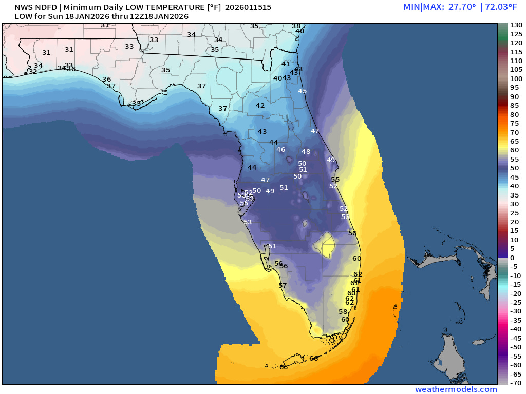
In a general sense, winter is not just coming, but already here as temperatures behind an initial cold front plummet below freezing across much of Florida on Friday morning. The National Weather Service has issued Freeze Warnings and Cold Weather Advisories south to Lake Okeechobee, with the exception of the immediate coast between Tampa and Cape Canaveral. North Florida can expect a hard freeze on Friday, with lows in the 20 to 25F range, so remember the 5 P’s of freeze safety: people, plants, pipes, pets, and Pokémon. Trainers, please recall all fire-type Pokémon from gyms immediately—if you’re cold, they’re cold.
This initial blast of Arctic chill will be dry and brief. By Saturday, high temperatures reach back into the 60s in the Panhandle and 70s for the peninsula, with some shower chances north as another front approaches.
And then things get weird.

As a deep trough in the jet stream pushes the cold front south Saturday night into Sunday morning, a separate disturbance will race east along the Gulf Coast, bringing rising air and moisture aloft. That system will trigger rain showers to develop overnight as the front drops temperatures from the 50s into the 30s across the Panhandle. If—and it’s a big if—some lingering moisture overlaps with the arrival of the colder air, the tail end of the precip might change over to a mix of rain and snow, or even just wet snow, from west to east between 6 a.m. and noon on Sunday. The best chance of this happening is north of I-10, particularly in the western Panhandle, extending into south Georgia and the Carolinas. Precip should end in North Florida by early afternoon, ahead of another deep freeze Monday morning.
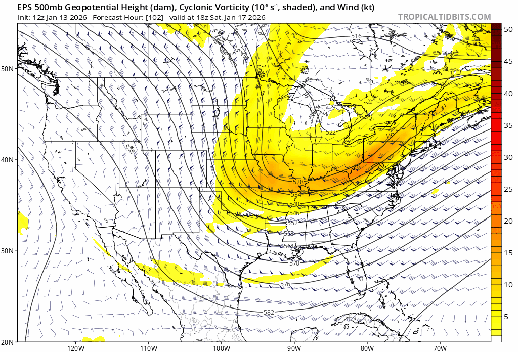
However, this set-up is even more of a bank shot that the typical Florida winter storm threat. My baseline skepticism towards weekend snow has been two-fold: first, model guidance lacked a well-defined second disturbance moving east from the Southern Plains to grant us lift and moisture during the cold snap. Over the last few days, models have trended stronger with this “kicker” shortwave trough, so that doubt has been assuaged. It’ll precipitate, at least a little.

The second doubt remains the sticking point. The trough over the Great Lakes is generally in the right place, but won’t be as uncommonly strong as the dips in the jet stream prior to big dog Florida snows in 1958, 1989, and 2025. A slightly weaker trough may well be unable to push cold air into the Panhandle fast enough to flip the last few hours of rain over to wet snow. As of Thursday morning, anywhere between a third and half of GFS and European model ensemble members show at least some snow in the Panhandle on Sunday morning, but models have a bias towards more moisture lingering behind fronts than is there in reality. That means North Florida could well see our snow chances literally evaporate as Sunday approaches.
Still, while there is a great deal of forecast uncertainty, the weekend weather pattern is close enough to the historical Panhandle winter storm set-up that a little snow, somewhere, is a realistic possibility. We may not have a good sense of when and where until Saturday night, and maybe not even then. In the meantime, here are three aspects of the storm we can discuss with more confidence, as highlighted by Tallahassee National Weather Service forecast discussions.
No sleet or freezing rain. Unlike the precipitation-type mayhem in Tallahassee last January, the options Sunday morning are more limited: rain, a mix of rain and snow, and wet snow, in order of likelihood/prevalence. Temperatures will be colder aloft and milder at the surface, so the melting and refreezing of falling flakes necessary for a repeat of #Tallahassleet will not occur.
Surface temps above freezing. Relatedly, temperatures across the Panhandle will drop into the mid to upper 30s Sunday morning as the front races south, but should remain above 32F. That rules out freezing rain and means that falling snowflakes will have to traverse above freezing temperatures before reaching the ground. So, if we do get any snow, it’ll likely be partially melted and very wet. It’ll also have trouble sticking to surfaces unless it’s really coming down, as highs Saturday will be in the 60s.
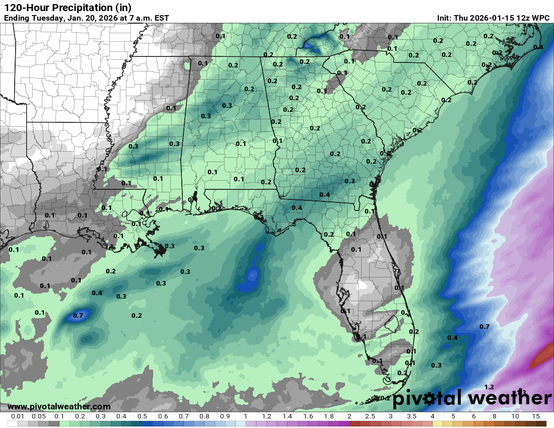
Limited precipitation totals. Perhaps the most unprecedented aspect of last year’s storm was just how much frozen precipitation fell in North Florida. While Tallahassee “only” saw 1.9” of sleet and snow, if you melted that down, it would have been almost 1” of liquid; other historical snowstorms in Florida, like December 1989, saw frozen precipitation liquid equivalents in the Panhandle of more like 0.1-0.25”. It was really a lot of ice last year, which explains why North Florida was unable to successfully do society for three whole days after the storm.
That won’t be the case this time. Including rain and snow, models suggest somewhere between 0.1-0.3” liquid equivalent across the Panhandle on Sunday (more like 0.25-0.5” in the peninsula, where snow is not on the table). Even in the exceptionally unlikely case all of that precipitation fell as snow, it would be nowhere near as much frozen… stuff… as 2025. A 2018-like coating of snow, if it is able to stick, would be much easier to recover from that last year’s event.
Remember that the last 140 some-odd years have brought accumulating snow just 14, 9, and 5 times in Pensacola, Tallahassee, and Jacksonville, respectively. In fact, Tallahassee has never seen accumulating snow events closer than three years apart. Rare events are rare for good reason. There is one way they can go right and a profusion of ways they can flop.
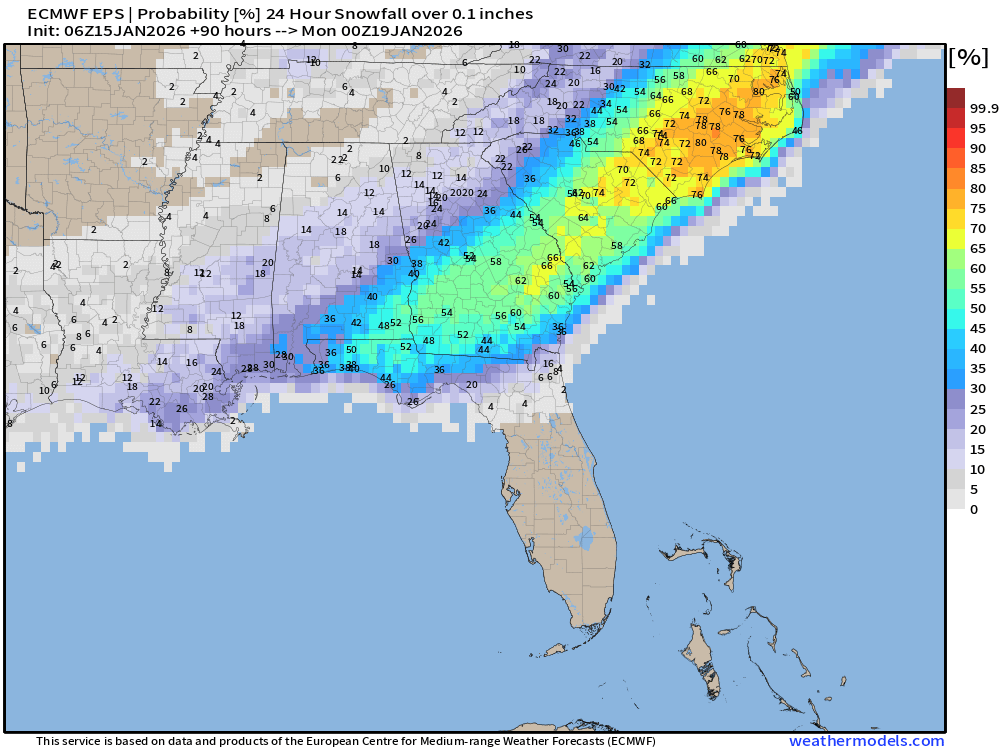
Overall, while my tentative guess is somewhere in the Panhandle (most likely between Crestview and Marianna) will report at least a few flakes, I suspect it just won’t be cold enough for snow for most of us. If that hunch is wrong and the Panhandle sees widespread accumulating snow, no one will be happier about it than my winter-loving heart. My time in New Jersey taught me to prepare for disappointment and be grateful for any snow that does emerge from hazy shades of winter. Stay warm, stay positive, and keep watching the skies.
If you have one of those copper backflow preventors sticking up in your front yard, wrap it up to keep it from freezing.
If you really get snow two years in a row your kids can tell their children how they had to walk to school in the snow. Both my Indiana parents claimed that.
Looking good here in south Port St Lucie/Palm City.