


Dry May to the Danger Zone?: WeatherTiger's Weekly Tropical Column for June 3rd
When looking for leading indicators of Florida landfall activity, is it gonna be May?

Welcome to WeatherTiger’s Hurricane Watch! On Thursday afternoons through October, we’ll be releasing a long-form column digging deeper on current conditions, or some other aspect of tropical meteorology or forecasting if the Atlantic is mostly quiet. Paid subscribers will receive these columns and be able to comment and ask questions, as well as get all of our daily forecast briefings, in-depth forecasts and video discussions during Florida hurricane threats, live landfall coverage, and expanded seasonal outlooks. Free subscribers subscribers will also receive this weekly forecast column. Sign up below to get WeatherTiger’s Hurricane Watch newsletters all season long.
The human mind is a finely tuned problem-solving and pattern-identifying machine. These skills served our ancestors well in repelling wild boar and Smilodon onslaughts with sharpened sticks. Yet, equally human is the tendency to see patterns where none exist, the way the History Channel and (apparently) the U.S. government now proclaim any object not bolted down to be an alien spacecraft.
This is especially true when the desired signal is embedded in an ocean of noise, and weather data is among the noisiest out there. WeatherTiger’s upcoming hurricane season outlook, as ever, walks a fine line between making useful projections and avoiding being fooled by the randomness of spurious correlations. Our June outlook does not include a projection of landfall risks for the season ahead, because overall seasonal activity is surprisingly independent of U.S. hurricane hits and we haven’t found a way to make reliably skillful predictions of landfall risk at this lead time.
Of course, landfall odds are what people care about most, so a variety of folk wisdoms exist to fill this vacuum. One piece of hurricane lore particularly relevant this year holds that a dry May in Florida is followed by a better chance of hurricane landfalls later that year in the state. Last month, as your water bills attest, was in the driest 20% of Mays for the majority of Florida, and the absolute driest on record for some in Central and South Central Florida.

This theory originated with Miami National Weather Service meteorologist Jim Lushine, who noted Hurricane Andrew followed an exceptionally dry spring in 1992 and found some evidence of a relationship between dry Mays and South Florida hurricane landfalls over the previous 75 years. However, this connection is anything but cut and dried (sorry), given the relative rarity of landfalls and the short timeframe of trustworthy tropical activity and rainfall records.
Historical datasets of U.S. precipitation and hurricane climatology have improved since Lushine’s original study, which could shed more light on this tricky question. For WeatherTiger’s investigation, we employed average May rainfall data over each of Florida’s 7 climate divisions as defined by NOAA’s National Centers for Environmental Information and hurricane position and intensity records from the National Hurricane Center’s definitive HURDAT2 dataset over 1900-2020. HURDAT2 records were used to calculate the annual number of hurricane landfalls and total storm energy (ACE) over South Florida, North Florida, and the state as a whole for each year.
First, our dive into the raw data shows there is definitely no relationship between North Florida rainfall and local or statewide hurricane activity, a point hammered home by Category 5 Hurricane Michael striking Panama City after Florida’s wettest May in the last 121 years.
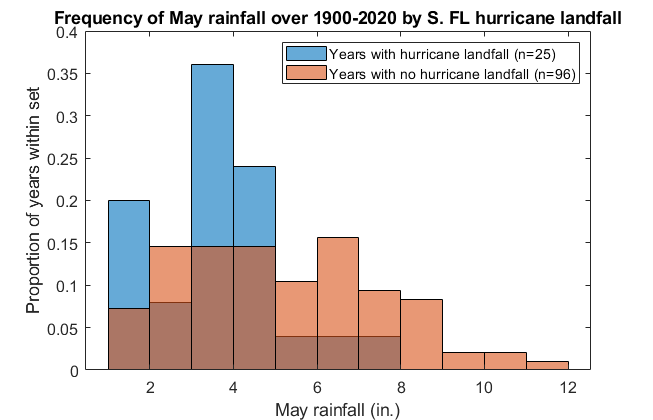
However, for South Florida, the results continue to be intriguing. Since 1900, May rainfall in the two South Florida mainland climate divisions explain 5 to 10% of the year-to-year changes in total storm activity over South Florida, which teeters on the edge of a meaningful difference. As seen above, in Southwest FL/Everglades climate district 5, average May rainfall is about 3.5” in the 25 years with one or more mainland South Florida hurricane strikes since 1900, and around 5” in the other 96 years. The difference between these groups of years is statistically stark, with one test suggesting greater than 1-in-1,000 odds of occurring by chance alone.
In South Florida’s driest 10% of Mays since 1900, a direct hurricane hit on the Southwest or Southeast Florida coast occurred later that year a little over 40% of the time, as opposed to around 20% otherwise. Of course, that 40% represents just five years out of the driest twelve since 1900, so a few random hurricane landfalls can dramatically skew perceptions.

Overall, our updated results continue to place Lushine’s conjecture in a murky gray area between “clearly something there” and “myth busted like the legend of two semi-trucks fusing with a Geo Metro.” The mechanism by which Lushine proposed his theory worked is that the strong high pressure keeping South Florida dry in May persists into the peak of the season and steers hurricanes towards the state. However, we ran the numbers on that idea (above), and found that anomalous high-pressure ridging in May does not predict August/September ridging between Florida and Bermuda in meaningful way.
It is important to remember that correlation does not equal causation, particularly when a clear physical link is missing. There is a strong correlation between the annual number of films Nic Cage released and U.S. drownings during 1999 to 2009. I shudder to consider the metaphysical ramifications if that relationship is causal. Bottom line: a dry May is good motivation to prepare for the hurricane season ahead, but not a clear or excessive long-term concern to Florida.

In the shorter term, wind shear is strong across the Gulf, Caribbean, and western Atlantic today, and tropical development is not expected for the next week. Upper-level winds may pivot into a more conducive state around June 10th, when a tropical wave currently in the eastern Atlantic will be entering the western Caribbean. It’s worth keeping an eye on this region starting late next week, as that is a climatologically favored area for development in the second week of June. Keep watching the skies.
Next update: WeatherTiger’s 2021 hurricane season outlook for June will be released tomorrow afternoon.