


Can't Get There From Here: Hurricane Lee Update for September 13th
Hurricane Lee is beginning its northward trek, and major coastal flooding, wind, and rain impacts are expected in Maine and Atlantic Canada Saturday and Sunday.
Enjoy this sample of WeatherTiger’s daily tropical bulletins, just one of the benefits of being a paid supporter of the Hurricane Watch. Sign up here to receive these forecasts each weekday.
Florida tropical threat synopsis: Hurricane Lee will cause high seas, rip currents, and beach erosion on Florida’s Atlantic coast through Sunday. No other tropical threats over the next 8 to 10 days.
Mood music:
Almanac: It’s Wednesday, September 13th… day 104 of the 2023 hurricane season, 79 days to go. By total storm energy, the season is 51.1%, 61.0%, and 51.8% complete for the Atlantic, continental U.S., and Florida, respectively.
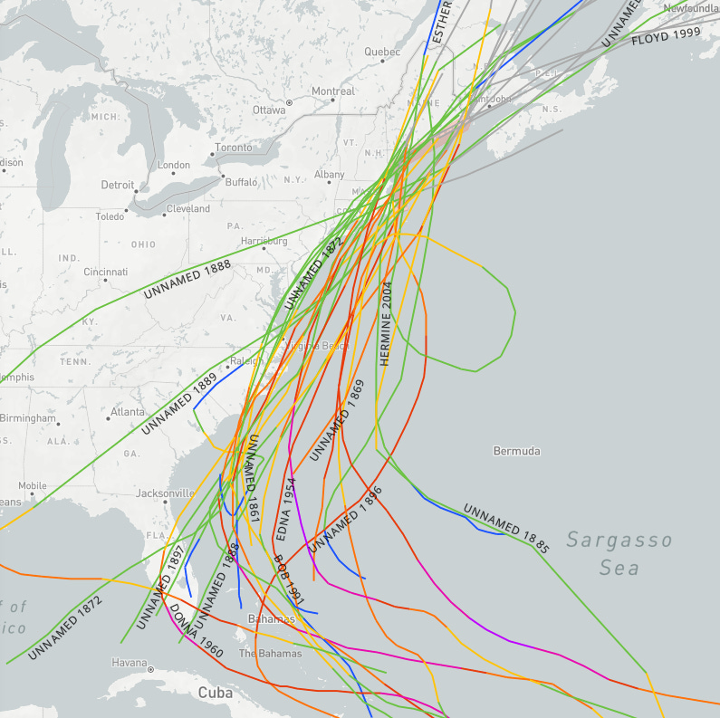
Taking a look at the hurricane history of eastern New England, 26 storms have crossed over Cape Cod or Maine at tropical storm or hurricane intensity, including Bob in 1991, Gerda in 1969, and Edna in 1954. All of these storms were undergoing extratropical transition at the time of impacts, as Lee will be. However, all historical eastern New England impacts moved in from the southwest or south-southwest. While the Mainer koan of “you can’t get there from here” would seem to apply to a hurricane approaching from the due south, that is exactly what Lee will do. Another historical oddity in the making, par for the course in 2023.
Active Storms:
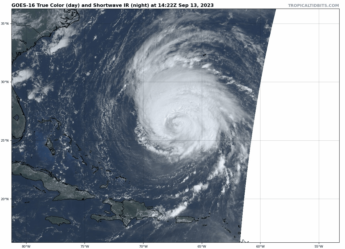
Hurricane Lee remains a Category 3 hurricane this afternoon with 115 mph sustained winds per the 11 a.m. NHC advisory. The hurricane continues to grow and will keep doing so even as maximum winds drop to Category 2 strength by tomorrow and Category 1 on Friday. This massive windfield, with the region of tropical-storm-force winds now over 425 miles in diameter, and of hurricane-force winds over 175 miles in diameter, is beginning to push the expected heavy seas into the Southeast Coast north of Palm Beach today. Coastal surf of 5-10’ from Florida into the Carolinas will peak on Friday and start to subside by Sunday. Rip currents and beach erosion will be issues there, but no other weather impacts will occur in the Southeast U.S. from Lee.
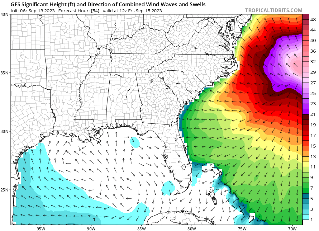
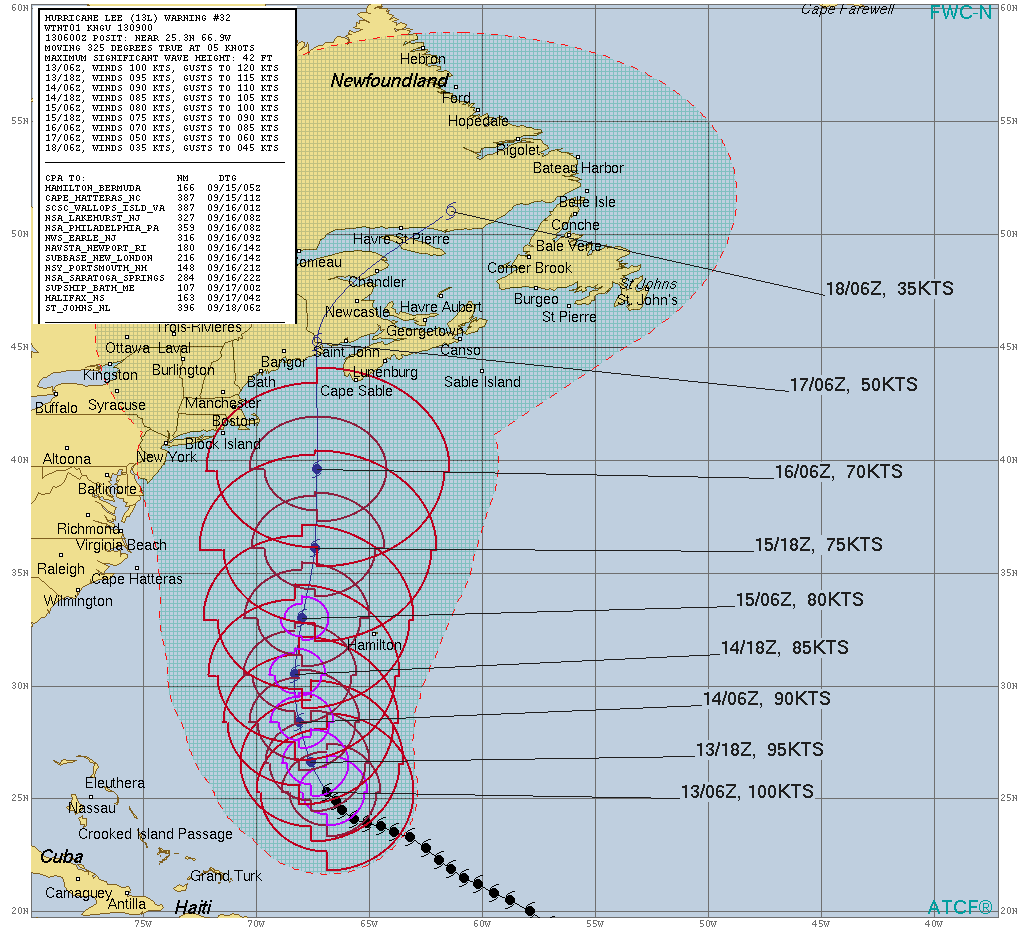
Peak Southeastern coast wave activity, Friday morning. With Lee’s expected mid-week turn north underway today and little track uncertainty through Friday, the hurricane will expand even more as it moves generally north towards eastern New England. NHC forecast Gale radii are projected to add up to a nearly 550-mile swath of 34-knot sustained winds by Saturday morning, when Lee is expected to be about 150-200 miles east-southeast of Cape Cod, as shown below.

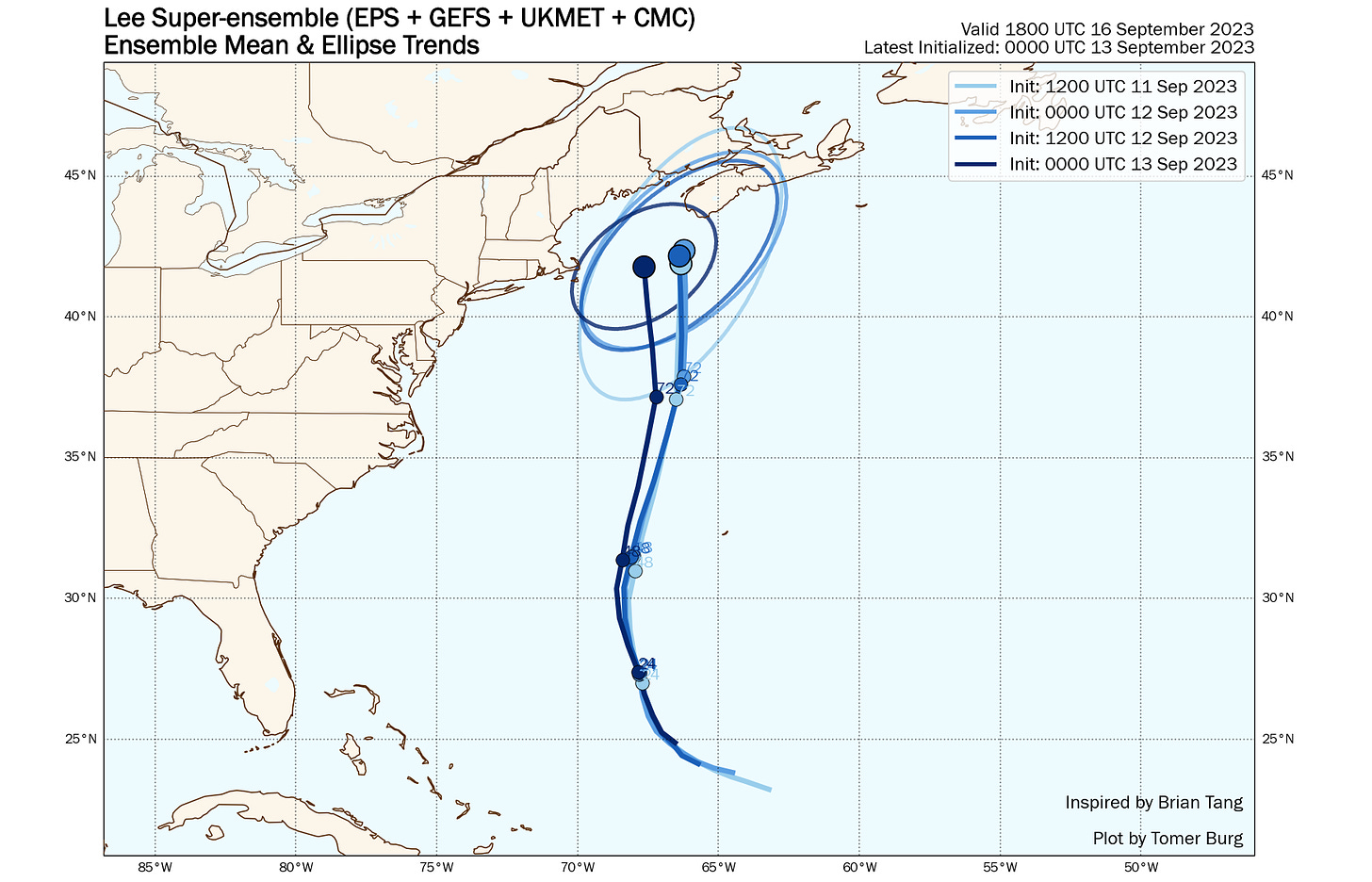
NHC track and TS wind radii through the weekend for Lee. Late Friday and during the day on Saturday, Lee may nudge a little west of due north as it merges with an existing frontal boundary. Since yesterday, models, especially the Euro, have tilted towards increased west-of-north movement, and as such the ensemble mean has moved about 75 miles west on Saturday since yesterday. While this shift would increase the rain and wind impacts in eastern Massachusetts if it occurs, Lee also appears to be turning north a bit more quickly than modeling had indicated, so a nudge back to the east in model track expectations may follow later today. It is still too early to say how much of New England will see heavy rain and tropical-storm-force wind gusts, though these conditions are near certain in eastern Maine and Atlantic Canada.
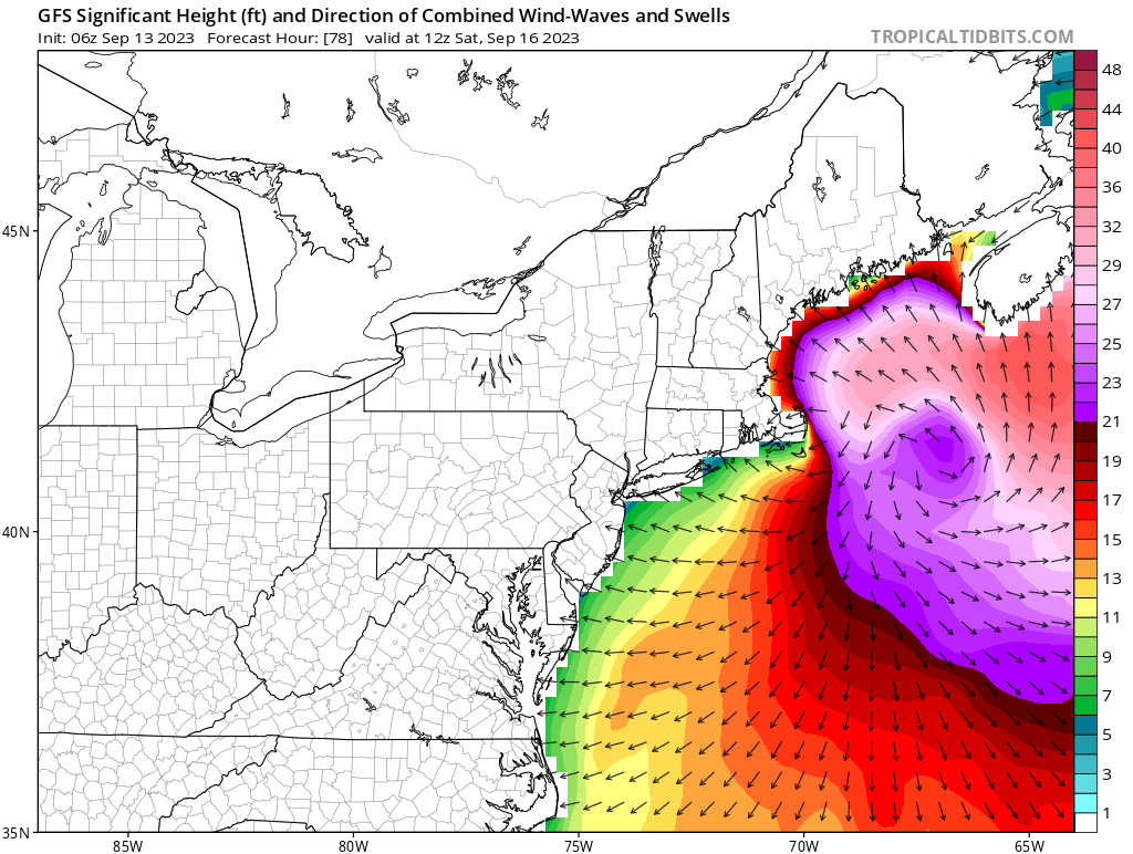
Last four ensemble mean model tracks for Lee; most recent in dark blue. Also not particularly sensitive to the exact track of Lee are the extreme seas that the hurricane will produce in the Gulf of Maine and Atlantic Canada this weekend. While the Outer Banks north to Rhode Island are likely to see 6-12’ seas on Friday and Saturday, Cape Cod north into Maine will see 10-20’+ seas, with 20-40’+ seas along and east of the center track into Atlantic Canada. This will also be coupled with significant surge for Nova Scotia, the Bay of Fundy, and potentially eastern Maine as well.

Peak wave action for the northeast U.S. on Saturday morning. As mentioned yesterday, the biggest unknown remains how far west stronger winds and heavy rain will plow; under the Euro’s more western scenario, Lee’s rain shield will reach west into New Hampshire and central Massachusetts on Saturday morning. This would also be coupled with coastal wind gusts of 40-60 mph from eastern Long Island east, and the potential for low-end tropical-storm force wind gusts even into Boston, plus hurricane-force gusts on Cape Cod. These impacts are not certain, and those lines could shift east depending on track and Lee’s structure as it becomes an extratropical cyclone on final approach to Maine or Nova Scotia. Bottom line, northern and eastern New England and Atlantic Canada should be well into preparing for the functional equivalent of a very strong Nor’easter hit.
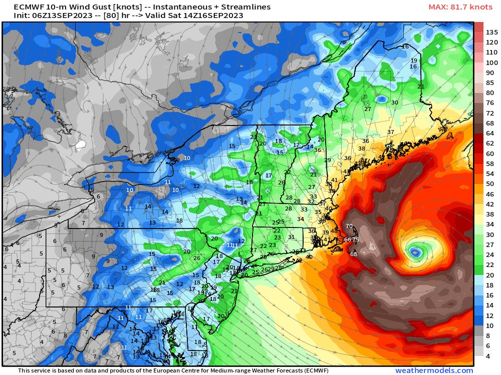
06z Euro windfield for Lee on Saturday morning, with TS-force wind gusts in yellow, orange, and red, and hurricane-force gusts in brown and white. Hurricane Margot has sustained winds of 90 mph in the eastern Subtropical Atlantic, and is slowing down approaching a region of weak steering winds. Margot will meander and slowly weaken over the next 3-5 days, and it is unclear if it will move north and dissipate by early next week or hang around over open waters into late next week. One thing is clear, though: it doesn’t matter.


Other disturbances in NHC outlook, with 2-/7-day NHC development odds: Invest 97L and 98L are rolling up into one super-invest in the central Tropical Atlantic. Convection is increasing and the NHC is giving this system an 80% chance of development, mostly likely between Friday and Sunday. Conditions are favorable for strengthening, and Tropical Storm/Hurricane Nigel is likely by early next week. However, western Atlantic troughing should turn anything that develops north well east of the U.S. East Coast late next week. Another threat to watch for Bermuda.
Elsewhere: No other features of note in the Atlantic today.
Next report: Daily bulletin out tomorrow afternoon for subscribers.