


Buckets of Rain: WeatherTiger's Hurricane Watch for September 7th
Rain chances increase for Florida through Thursday due to a weak Gulf disturbance.

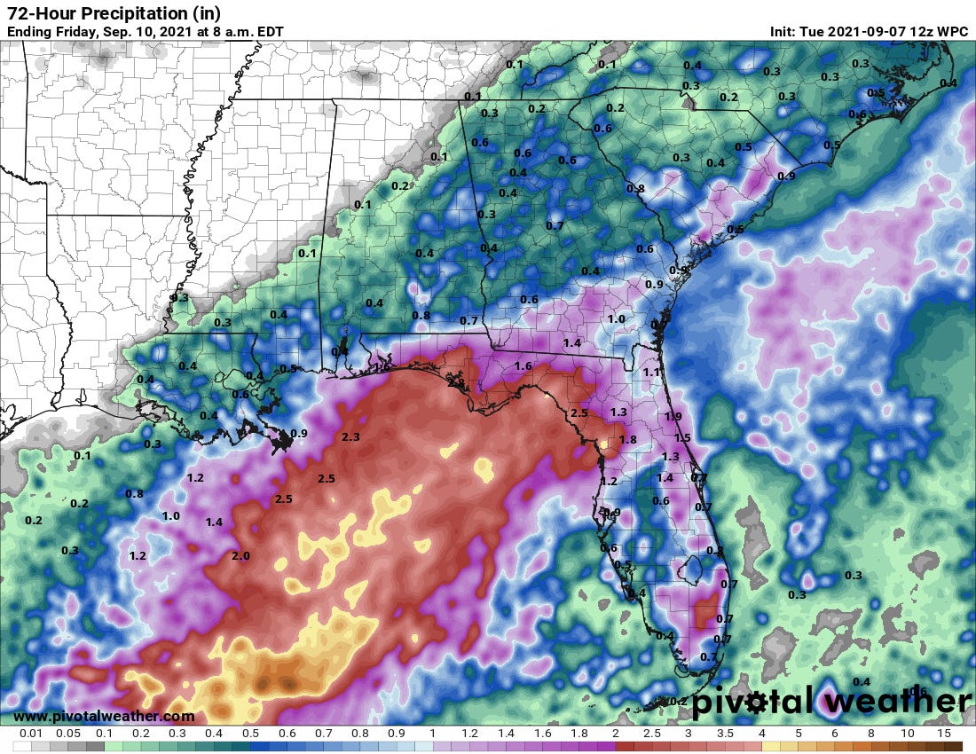
Two-sentence Florida tropical threat synopsis: Florida will see enhanced rain chances over the next 72 hours from a weak tropical low that is expected to cross North Florida early on Thursday. There is some chance of a tropical depression or even a weak tropical storm developing in the northern Gulf before then, but the only significant impact on Florida will be 1-3” of rain with or without development.

Almanac: It’s Tuesday, September 7th… day 98 of the 2021 hurricane season, 85 days to go. By storm energy, the season is 39.7% complete as a whole, 52.6% complete for the continental U.S., and 42.9% complete for Florida.
As of the halfway point of the season from a U.S. impacts perspective, 2021 has been a very active. U.S. ACE in 2021 exceeds about 29 out of every 30 hurricane seasons through early September, more than doubling the average U.S. ACE value for the entire hurricane season.

Active Storms: Hurricane Larry remains very much Hurricane Larry as it plods across the open central Atlantic. Larry has spent most of the long weekend as a Category 3 hurricane with a notably large eye up to 70 miles wide, and remains a Cat 3 this morning with 120 mph sustained winds.

Larry has been a well-behaved hurricane and will pass east of Bermuda over the next few days, becoming extratropical over the North Atlantic later this week. The only impact of Larry on the continental U.S. will be widespread 5-10’ easterly swell over much of the U.S. East Coast. Surf’s up.

Current disturbances in NHC outlook, with 2-/5-day NHC development odds:
Invest 91L (10/30%): An area of disorganized showers and storms in the south central Gulf of Mexico associated with a weak trough of low pressure is looking a little more concentrated this morning north of the Yucatan peninsula.

While 91L has some mid-level rotation association with it, there is currently little to no surface organization. This disturbance has about 36 to 48 hours to develop before it crosses over North Florida early on Thursday, steered quickly east-northeast by a front pushing south across the eastern U.S.; it may also get another brief crack at development southeast of the Carolinas Friday or Saturday, as shown on the 06z Euro below.

Overall, given the uptick in convection this morning, there is some chance of a tropical depression or even a weak tropical storm forming prior to 91L reaching North Florida early on Thursday, and a perhaps 50/50 shot at something (weak) developing over the Gulf Stream later in the week. Overall, the limited time 91L has over water before reaching the coast means expected impacts on Florida are not dependent on 91L receiving a name. Look for 1-3” of rainfall over the next 72 hours for the northern half of Florida, including the Panhandle, with 0.75-1.5” for South Florida. Some brief gusts to 30-40 mph in squalls are also possible over North Florida coastal waters. We’ll keep an eye on 91L, but concerns are minimal.


Elsewhere: No other active disturbances. The western Gulf may see another chance of tropical development in 5-7 days, and there continues to be vague model support for an uptick in Cape Verde activity in 6-10 days. Neither of these areas would be of any immediate concern for Florida.
Next report: Next report Wednesday afternoon unless the threat to Florida from 91L changes significantly.