Brutal Out There: WeatherTiger's Hurricane Watch for August 27th
Hurricane Ida is 48 hours from a disaster on the central Gulf Coast.
Two-sentence Florida tropical threat synopsis: Hurricane Ida will strike Louisiana as a major hurricane late Sunday or early Monday, but impacts on the Florida Panhandle will be limited to a few inches of rain and tides 1-2’ above normal. Several other areas are likely to develop into depressions or storms in the next 7-10 days, but there are no specific threats to Florida yet.
Active Storms: Hurricane Ida has rapidly intensified today to a Category 1 hurricane with 80 mph sustained winds, doubling maximum sustained winds since yesterday at 5 p.m. An inner core ringed by intense convection has developed today; look for a stutter-step in intensity as Ida crosses western Cuba tonight, followed by what is extremely likely to be continued rapid intensification from tomorrow into at least Sunday morning. The NHC intensity forecast at 5 p.m. is even more aggressive than yesterday, now calling for a 140 mph Category 4 hurricane landfall on Sunday evening in central Louisiana.
The track forecast, as expected, is little changed from yesterday, and a northwest course at 10-15 mph towards central or southeastern Louisiana remains a high-confidence call. Essentially none of the models or even ensemble members are deviating from this scenario, with no overall change in the strength of weekend ridging over the Carolinas since yesterday. Hurricane and Storm Surge Warnings are now in effect for all of Louisiana east of Intercoastal City, including New Orleans.
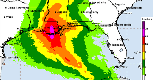
It remains unknown exactly where the worst of Ida will be felt, but a swath of Laura-like devastating wind impacts is likely to fall somewhere between Lafayette and New Orleans, and extend well inland. Surge impacts in eastern Louisiana will be a catastrophic 8-12’ or more, with significant and damaging surge extending east to Mobile Bay. Widespread rainfall of 7-15” is expected in eastern Louisiana, which on its own is likely to cause severe issues in New Orleans outside of wind.
In short, those in Louisiana under evacuation orders should be heeding them, and all residents of southern Louisiana should be carefully weighing whether to leave or stay tonight. Most inland will not receive the brunt of the expected Category 4 core of Ida, but it is a possibility for all south central and southeastern Louisiana.
We will have more on the expected wind, surge, and rain impacts of Ida in a live video on our Facebook page at 8 p.m. ET/7 p.m. CT tonight.
Current disturbances in NHC outlook, with 2-/5-day NHC development odds:
Invest 97L (40/60%): Convection is anemic today with this disturbance east of Bermuda. Some development is possible over the next few days, but will be of no concern to any landmass.
Invest 98L (80/80%): This disturbance several hundred miles east of the Lesser Antilles has a well-defined circulation but little convection. Brief development is probable over the next few days as it turns north well away from the islands. Not a threat.
Eastern Atlantic (0/20%): Watch for additional development in 5-8 days in the eastern Atlantic, which will initially propagate westward. Steering currents seem to favor an eventual turn north into the open Atlantic sometime in week 2, but confidence is low at this range.
Elsewhere: Keep an eye on the northwestern Caribbean in the wake of Ida. Overall, this can wait.
Next report: A video discussion of Ida will be livestreamed on our Facebook page at 8 p.m. ET/7 p.m CT tonight, and subsequently uploaded to YouTube and sent to all subscribers.


