


Bills, Bills, Bills: WeatherTiger's Hurricane Watch for June 15th
The second storm of 2021 is on the board, and the Gulf should bring #3 this weekend.

Welcome to WeatherTiger’s Hurricane Watch! Each weekday we’ll have a tropical briefing bringing you that day’s hurricane history, a run-down of active storms, and a look at current development threats. Paid subscribers will receive these daily briefings and be able to comment and ask questions, as well as get our Thursday long-form analysis columns, daily forecasts and video discussions during hurricane threats, live landfall coverage, and expanded seasonal outlooks. Free subscribers will receive our weekly forecast column and selected storm coverage.
A free preview of our daily briefing will continue into June as we settle into our new Substack digs. Enjoy, and feel free to drop a line to ryan@weathertiger.com with any questions.

Almanac: Today is Tuesday, June 15th… day 15 of the 2021 hurricane season, 169 days to go. By total storm energy, the season is 1.5% complete as a whole, 3.5% complete for the continental U.S., and 4.8% complete for Florida. On this date in 1893, a tropical storm with 70 mph winds made landfall near—where else but—Steinhatchee on the Florida Gulf Coast. This originally was counted as a category 1 hurricane landfall, but downgraded to a tropical storm at impact upon further review in the 2000s.
The middle two weeks of June (above) historically have a mix of eastern and western Gulf landfalls, with the frequency of hurricane landfalls rising a bit into late June.
Active Storms: Tropical Storm Bill developed last night from Tropical Depression 2, strengthening to a mid-range tropical storm with 60 mph sustained winds as it passed over the warm Gulf Stream waters well north of Bermuda.
Bill is leaving the Gulf Stream currently, and this afternoon appears to be transitioning back to a non-tropical low as it does. It will impact southern Newfoundland with a brief blast of gale force wind and heavy rain tomorrow morning.

Current disturbances in NHC outlook:
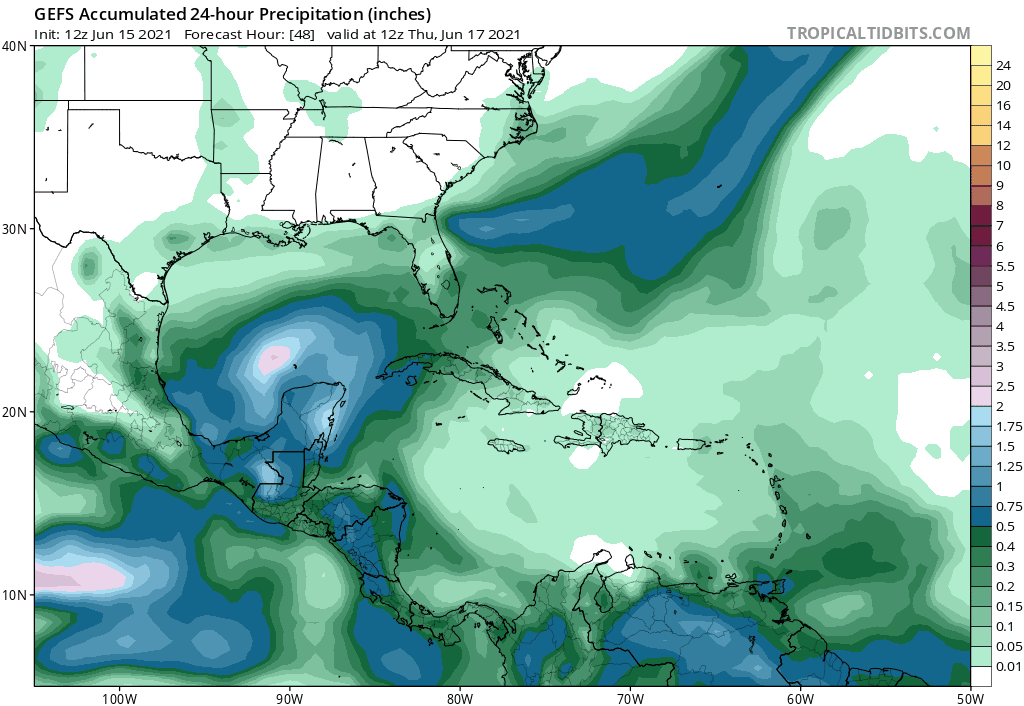
Invest 92L/Southern Gulf (2-/5-day odds: 40/80%). Invest 92L continues to trend in the direction of yielding a sloppy, rainmaking Gulf Coast tropical storm for the upcoming weekend. The low-level circulation this afternoon remains pinned down in the far southern Gulf of Mexico along the Mexican Coast, and land proximity is likely to prevent tropical development through Thursday. Late this week, interaction with another tropical wave approaching from the east and eastern U.S. troughing will bring 92L north, at which point a broad tropical or subtropical depression is likely to develop.

With multiple areas of low-level spin inside of a broad circulation and shear likely remaining in the 15-20 knot range as 92L comes north, it is unlikely that windspeeds will exceed mid-range tropical storm strength. (Should 92L become a subtropical or tropical storm, it will be named Claudette.) Rather, the primary impact of 92L will be rainfall along and well east of the track of the circulation center. A general course in the direction of Louisiana is likely to mean the heaviest rainfall will extend from central Louisiana east to the western Florida Panhandle, as shown below on the 12z GFS Ensembles. An area of 4-8”+ coastal and 2-5”+ inland rain totals across the Deep South is likely as this system hooks right once it comes onshore Saturday or Sunday; precip forecasts will continue to be refined through the week as 92L shapes up, but Louisiana should brace for additional flood risks on top of recent excessive precip.
Invest 94L/Eastern Atlantic (2-/5-day odds: 10/10%): As expected, yesterday’s impressive tropical wave has gone poof as it moved west into tepid waters. A mid-level circulation remains, but significant convection is unlikely to return. No development here, particularly as the wave is mixed up with plenty of stable African dust.


Elsewhere: Another ex-frontal low in Bill’s footsteps may try to waste a name north of Bermuda sometime between Thursday and Saturday, but there is no threat to land.
Next report: The next daily briefing will be issued by 3 p.m. Wednesday.