


Ana begins: WeatherTiger's Hurricane Watch for May 21st
The year's first subtropical storm is developing near Bermuda as a Gulf low brings rain to Texas.

Welcome to WeatherTiger’s Hurricane Watch! From June 1st through October 31st, I’ll be issuing a daily tropical briefing bringing you that day’s hurricane history, a quick run-down of active storms, and a look at current development threats. Paid subscribers will receive these briefings each weekday and be able to comment and ask questions, as well as get all of our weekly analysis columns, daily in-depth forecasts and video discussions during U.S. hurricane threats, live landfall coverage, and exclusive expanded seasonal outlooks. Free subscribers subscribers will receive our weekly forecast column. Sign up below to get WeatherTiger’s Hurricane Watch newsletters all season long.
Enjoy this free preview of our daily briefing as we watch a pair of “pre-season” disturbances. (Shade quotes intentional— our thoughts on that here.)
Almanac: Today is Friday, May 21st… the 2021 hurricane season officially starts in 12 days and ends in 194 days. By total storm energy, the season is 0.3% complete as a whole, 0.3% complete for the continental U.S., and 0.4% complete for Florida. The next U.S. landfall anniversary on the calendar is Subtropical Storm One, which struck Florida’s Big Bend on May 23, 1976.
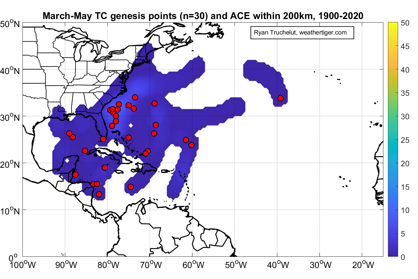
Climatologically, as shown above, spring (March-May) tropical or subtropical storm development generally takes place in the eastern Gulf, Caribbean, or subtropical western Atlantic. These events have become much more common in the last several decades, partially due to better detection, and partially due to warming ocean waters.
Active Storms: None (yet).
Current disturbances:
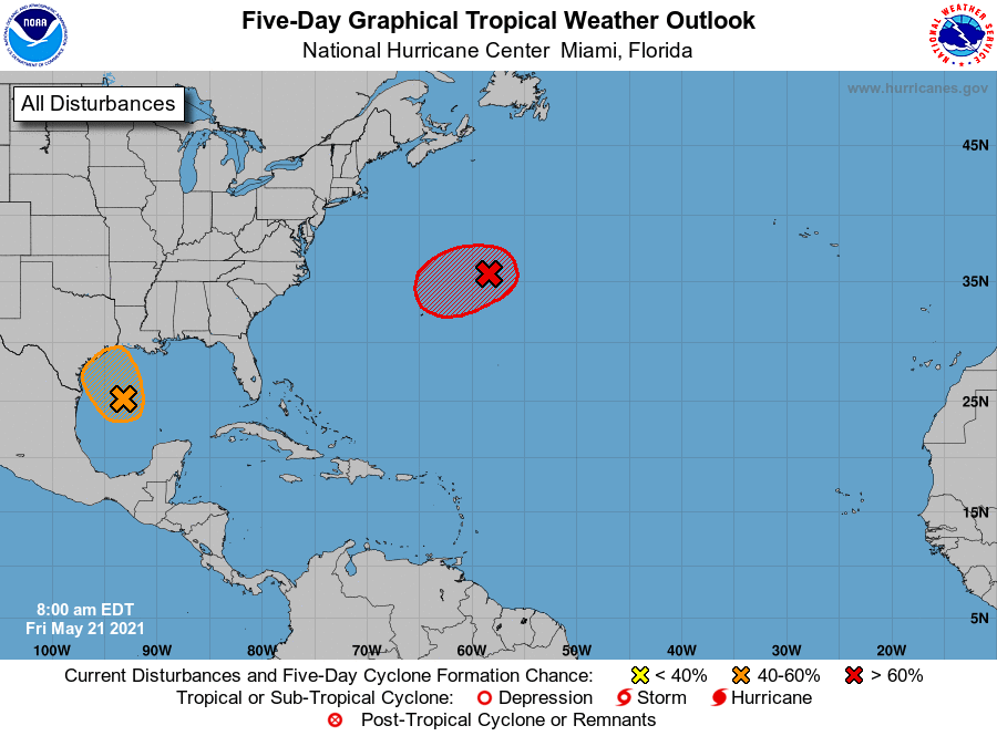
Invest 90L near Bermuda (NHC 2-/5-day odds: 90%/90%): A subtropical storm is on the verge of forming this afternoon northeast of Bermuda. Convection is increasing near a developing shallow warm core, so as soon as 90L sheds the last vestiges of its frontal origins, it likely will be given the name Ana.

Ana will meander northeast of Bermuda through Sunday before accelerating northeast into the northern Atlantic and weakening on Monday. This will be the seventh consecutive year with a subtropical or tropical storm prior to June 1st, and also the farthest north development on record between March 1st and May 31st.
Invest 91L in the western Gulf (NHC 2-/5-day odds: 40%/40%): But wait, there’s more. A thunderstorm complex that moved offshore Texas earlier this week has developed a well-defined surface circulation over the Gulf as it heads back towards land. Invest 91L is one convective burst away from being a tropical depression, but I don’t think that will happen due to marginal sea surface temperatures and some nearby dry air.
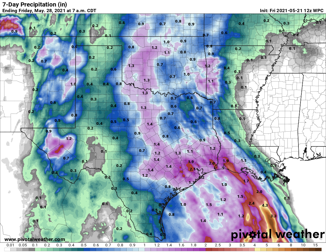
Invest 91L will move north into Texas on Saturday. Whether or not it becomes a short-lived depression before doing so, the key impact from 91L will be additional rainfall of 1-2” in already-soaked eastern Texas through the weekend.


Elsewhere: No other tropical disturbances to discuss today.
Next report: As needed; daily tropical briefings will begin on June 1st. WeatherTiger’s 2021 updated hurricane season outlook will be issued on June 4th.